|
|
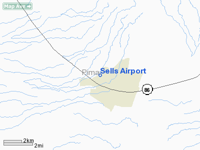
Location & QuickFacts
|
FAA Information
Effective: |
2005-10-27 |
|
Airport Identifier: |
E78 |
|
Longitude/Latitude: |
111-53-39.4440W/31-55-58.2740N
-111.894290/31.932854 (Estimated) |
|
Elevation: |
2409 ft / 734.26 m (Surveyed) |
|
Land: |
20 acres |
|
From nearest city: |
2
nautical miles NW of Sells, AZ |
|
Location: |
Pima County, AZ |
|
Magnetic Variation: |
12E (1985) |
Owner & Manager
|
Ownership: |
Publicly owned |
|
Owner: |
Tohono O'odham Nation |
|
Address: |
Po Box 837
Sells, AZ 85634 |
|
Phone number: |
520-383-2028 |
|
Manager: |
Unknown |
|
Address: |
Po Box 837
Sells, AZ 85634 |
|
Phone number: |
520-383-2028 |
Airport Operations and Facilities
|
Airport Use: |
Open to public |
|
Wind indicator: |
Yes
WINDSOCKS MISSING FROM POLES. |
|
Segmented Circle: |
No |
|
Control Tower: |
No |
|
Attendance Schedule: |
UNATNDD |
|
Landing fee charge: |
No |
|
Sectional chart: |
Phoenix |
|
Region: |
AWP - Western-Pacific |
|
Boundary ARTCC: |
ZAB - Albuquerque |
|
Tie-in FSS: |
PRC - Prescott |
|
FSS on Airport: |
No |
|
FSS Phone: |
928-778-7810 |
|
FSS Toll Free: |
1-800-WX-BRIEF |
|
NOTAMs Facility: |
PRC (NOTAM-d service avaliable) |
Airport Communications
Airport Services
|
Airframe Repair: |
NONE |
|
Power Plant Repair: |
NONE |
|
Bottled Oxygen: |
NONE |
|
Bulk Oxygen: |
NONE |
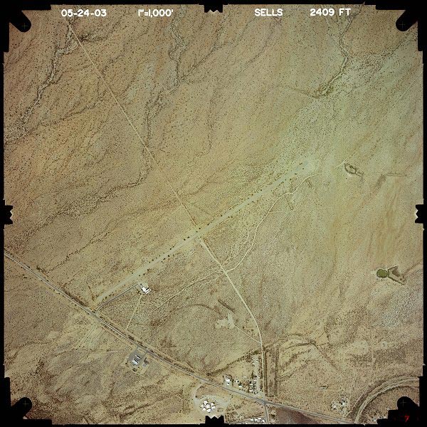
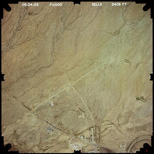
Runway Information
Runway 04/22
|
Dimension: |
5830 x 48 ft /
1777.0 x 14.6 m
WIDTH 60 FT IN SOME AREAS; NARROWER DUE TO BUSHES GROWING THRU PAVEMENT. |
|
Surface: |
ASPH,
Fair Condition |
|
Weight Limit: |
Single
wheel: 12500 lbs. |
|
|
Runway 04 |
Runway 22 |
|
Traffic Pattern: |
Left |
Left |
|
Markings: |
Nonstandard, Poor Condition
/22 MKD WITH 6 INCH YELLOW CNTRLN STRIPE ONLY; MKGS FADED. |
Nonstandard, Poor Condition |
|
Runway End Identifier: |
No |
No |
|
Centerline Lights: |
No |
No |
|
Touchdown Lights: |
No |
No |
|
Obstruction: |
30
ft tree, 294.0 ft from runway, 130 ft right of centerline,
3:1 slope to clear
3 FT BANK 132 FT FROM EOR 0B. |
15
ft trees, 210.0 ft from runway, 50 ft right of centerline
12 FT TREE 123 FT FROM EOR & 59 FT R; 4 FT FENCE 75 FT
FROM EOR 0B. |
|
Radio Navigation Aids
|
ID |
Type |
Name |
Ch |
Freq |
Var |
Dist |
|
RBJ |
NDB |
Robles |
|
220.00 |
12E |
28.5 nm |
|
RYN |
NDB |
Ryan |
|
338.00 |
12E |
39.3 nm |
|
AVQ |
NDB |
Marana |
|
245.00 |
12E |
45.0 nm |
Remarks
-
5 TIEDOWNS IN PRIMARY SFC.
-
LIVESTOCK ON INVOF ARPT.
-
ESTABD PRIOR TO 5/15/59.
Based Aircraft
|
Aircraft based on field: |
1 |
|
Single Engine Airplanes: |
1 |
Operational Statistics
|
Aircraft Operations: |
26/Week |
|
Air Taxi: |
15.3% |
|
General Aviation Local: |
7.6% |
|
General Aviation Itinerant: |
76.3% |
|
Military: |
0.8% |
Sells Airport
Address:
Pima County, AZ
Tel:
520-383-2028
|
 |
(Click on the image to enlarge) |
Images and information placed above are from
http://www.airport-data.com/airport/E78/
http://www.dot.state.az.us/aviation/airports/airports_list.asp?FAA=E78
We thank them for the data!
| General
Info |
| Country |
United
States |
| State |
ARIZONA
|
| FAA ID |
E78 |
| Latitude |
31-55-58.274N
|
| Longitude |
111-53-39.444W
|
| Elevation |
2409 feet
|
| Near City |
SELLS
|
We don't guarantee the information is fresh and accurate. The data may be wrong or outdated.
For more up-to-date information please refer to other sources.
|
|