|
|
Location & QuickFacts
|
FAA
Information Effective: |
2005-10-27 |
|
Airport Identifier: |
P23 |
|
Longitude/Latitude: |
112-53-14.0000W/35-20-06.0000N
-112.887222/35.335000 (Estimated) |
|
Elevation: |
5235 ft / 1595.63 m (Estimated) |
|
Land: |
140 acres |
|
From nearest city: |
1
nautical miles NW of Seligman, AZ |
|
Location: |
Yavapai County, AZ |
|
Magnetic Variation: |
13E (1985) |
Owner & Manager
|
Ownership: |
Publicly owned |
|
Owner: |
Yavapai County
LEASED TO YAVAPAI COUNTY AS LONG AS AN ARPT IS MAINTAINED. |
|
Address: |
1100 Commerce Drive
Prescott, AZ 86305 |
|
Phone number: |
928-771-3183 |
|
Manager: |
Richard Straub |
|
Address: |
Yavapai County Dir Public Works, 1100 Commerce Dr
Prescott, AZ 86305 |
|
Phone number: |
928-771-3183 |
Airport Operations and Facilities
|
Airport
Use: |
Open to public |
|
Wind indicator: |
Yes |
|
Segmented Circle: |
Yes |
|
Control Tower: |
No |
|
Attendance Schedule: |
UNATNDD |
|
Lighting Schedule: |
DUSK-DAWN
ACTVT MIRL RY 04/22 AND PAPI RYS 04 & 22 - CTAF. REIL RYS 04
& 22 ACTIVATED WITH 7-CLICKS ONLY - CTAF. |
|
Beacon Color: |
Clear-Green (lighted land airport) |
|
Landing fee charge: |
No |
|
Sectional chart: |
Phoenix |
|
Region: |
AWP - Western-Pacific |
|
Boundary ARTCC: |
ZLA - Los Angeles |
|
Tie-in FSS: |
PRC - Prescott |
|
FSS on Airport: |
No |
|
FSS Phone: |
928-778-7810 |
|
FSS Toll Free: |
1-800-WX-BRIEF |
|
NOTAMs Facility: |
PRC (NOTAM-d service avaliable) |
Airport Communications
Airport Services
|
Airframe
Repair: |
NONE |
|
Power
Plant Repair: |
NONE |
|
Bottled Oxygen: |
NONE |
|
Bulk Oxygen: |
NONE |
Runway Information
Runway 04/22
|
Dimension: |
4800
x 75 ft / 1463.0 x 22.9 m |
|
Surface: |
ASPH,
Good Condition |
|
Edge Lights: |
Medium |
|
|
Runway 04 |
Runway 22 |
|
Elevation: |
5237.00 ft |
0.00 ft |
|
Traffic Pattern: |
Left |
Right |
|
Markings: |
Basic, Good Condition |
Basic, Good Condition |
|
VASI: |
2-light PAPI on left side |
2-light PAPI on left side |
|
Visual Glide Angle: |
3.00� |
3.00� |
|
Runway End Identifier: |
Yes |
Yes |
|
Centerline Lights: |
No |
No |
|
Touchdown Lights: |
No |
No |
|
Obstruction: |
9
ft fence, 270.0 ft from runway, 125 ft right of centerline,
7:1 slope to clear |
,
50:1 slope to clear
RY 22, 9 FT FENCE 199 FT FM RY END 0B. |
|
Radio Navigation Aids
|
ID |
Type |
Name |
Ch |
Freq |
Var |
Dist |
|
PGS |
VORTAC |
Peach
Springs |
057X |
112.00 |
15E |
36.6
nm |
|
DRK |
VORTAC |
Drake |
088X |
114.10 |
14E |
43.0
nm |
|
PRC |
VOT |
Prescott |
|
110.00 |
|
47.0
nm |
Remarks
-
DRAINAGE CHANNEL BOTH
SIDES FULL LENGTH OF RY 04/22, VARIES IN WIDTH AND DEPTH.
-
DRAINAGE CHANNEL 65
FT WIDE, 4-10 FT DEEP LCTD 200-265 FT FM APCH END RY 22.
-
VFR USE ONLY; CAUTION
EXERCISED IN MCAS/YUMA ARPT. AREA.
Based Aircraft
|
Aircraft
based on field: |
4 |
|
Single Engine Airplanes: |
4 |
Operational Statistics
|
Aircraft
Operations: |
22/Week |
|
General Aviation
Local: |
45.5% |
|
General Aviation
Itinerant: |
54.5% |
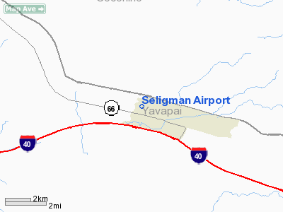
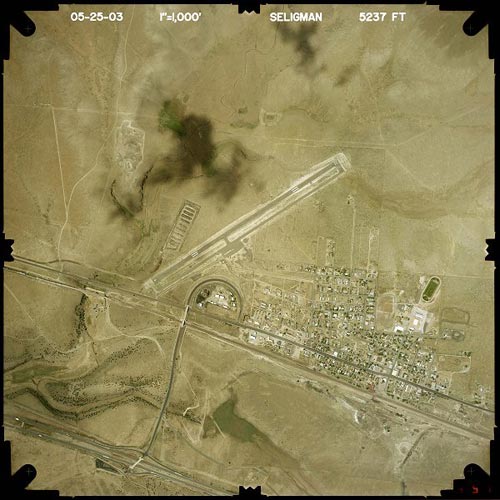
Seligman Airport
Address:
Yavapai County,
AZ
Tel:
928-771-3183
|
 |
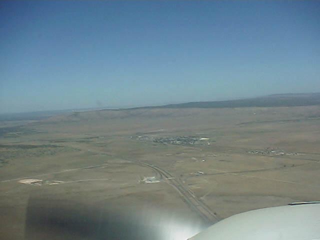
Looking westerly. The airport
is just the other side of town.
(Click on the image to enlarge) |
|
 |
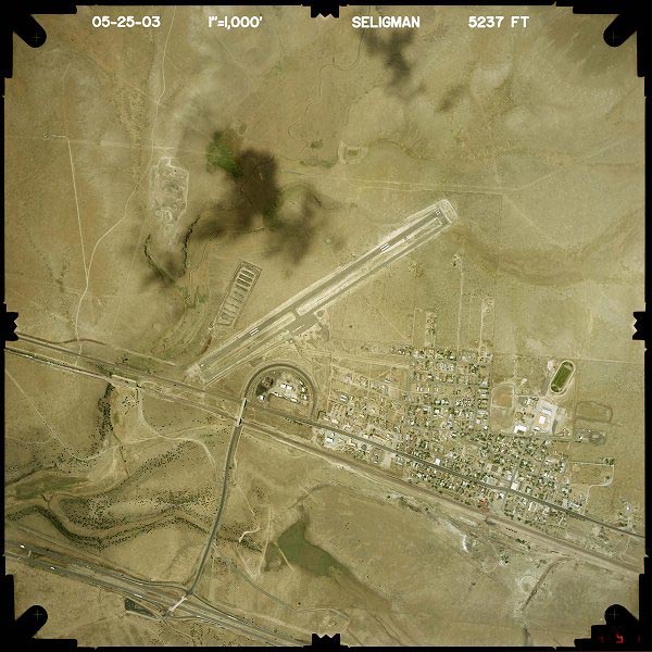
(Click on the image to enlarge) |
Images and information placed above are from
http://www.airport-data.com/airport/P23/
http://www.airfieldinfo.com/seligman.html
http://www.dot.state.az.us/aviation/airports/airports_list.asp?FAA=P23
We thank them for the data!
| General
Info |
| Country |
United
States |
| State |
ARIZONA
|
| FAA ID |
P23 |
| Latitude |
35-20-06.000N
|
| Longitude |
112-53-14.000W
|
| Elevation |
5235 feet
|
| Near City |
SELIGMAN
|
We don't guarantee the information is fresh and accurate. The data may be wrong or outdated.
For more up-to-date information please refer to other sources.
|
|