|
|
Location & QuickFacts
|
FAA
Information Effective: |
2005-10-27 |
|
Airport Identifier: |
E77 |
|
Longitude/Latitude: |
110-38-50.3510W/32-38-11.2530N
-110.647320/32.636459 (Estimated) |
|
Elevation: |
3274 ft / 997.92 m (Estimated) |
|
Land: |
54 acres |
|
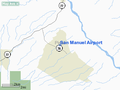
From nearest city: |
2
nautical miles NW of San Manuel, AZ |
|
Location: |
Pinal County, AZ |
|
Magnetic Variation: |
12E (1985) |
Owner & Manager
|
Ownership: |
Privately owned |
|
Owner: |
Bhp
LEASED TO PINAL CO. |
|
Address: |
Hwy 76
San Manuel, AZ 85631 |
|
Phone number: |
520-385-3203 |
|
Manager: |
Robert Bateman |
|
Address: |
Po Box 827
Florence, AZ 85232 |
|
Phone number: |
520-866-6545 |
Airport Operations and Facilities
|
Airport
Use: |
Private |
|
Wind indicator: |
Yes |
|
Segmented Circle: |
Yes |
|
Control Tower: |
No |
|
Attendance Schedule: |
UNATNDD
ARPT CLOSED FROM 2000-0600 DAILY. |
|
Lighting Schedule: |
NONE |
|
Landing fee charge: |
No |
|
Sectional chart: |
Phoenix |
|
Region: |
AWP - Western-Pacific |
|
Boundary ARTCC: |
ZAB - Albuquerque |
|
Tie-in FSS: |
PRC - Prescott |
|
FSS on Airport: |
No |
|
FSS Phone: |
928-778-7810 |
|
FSS Toll Free: |
1-800-WX-BRIEF |
|
NOTAMs Facility: |
PRC (NOTAM-d service avaliable) |
Airport Communications
Airport Services
|
Airframe
Repair: |
NONE |
|
Power
Plant Repair: |
NONE |
|
Bottled Oxygen: |
NONE |
|
Bulk Oxygen: |
NONE |
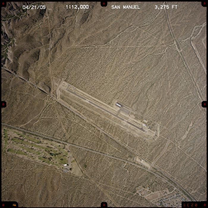
Runway Information
Runway 11/29
|
Dimension: |
4200 x 75 ft /
1280.2 x 22.9 m |
|
Surface: |
ASPH,
Good Condition |
|
Weight Limit: |
Single
wheel: 12000 lbs. |
|
|
Runway 11 |
Runway 29 |
|
Elevation: |
3275.00 ft |
0.00 ft |
|
Traffic Pattern: |
Left |
Right |
|
Markings: |
Basic, Good Condition |
Basic, Good Condition |
|
Runway End Identifier: |
No |
No |
|
Centerline Lights: |
No |
No |
|
Touchdown Lights: |
No |
No |
|
Radio Navigation Aids
|
ID |
Type |
Name |
Ch |
Freq |
Var |
Dist |
|
AVQ |
NDB |
Marana |
|
245.00 |
12E |
31.8
nm |
|
RYN |
NDB |
Ryan |
|
338.00 |
12E |
39.7
nm |
|
GAZ |
NDB |
Globe |
|
255.00 |
13E |
43.2
nm |
|
RBJ |
NDB |
Robles |
|
220.00 |
12E |
49.5
nm |
|
DMA |
TACAN |
Davis
Monthan |
123X |
|
12E |
31.0
nm |
|
TUS |
VORTAC |
Tucson |
107X |
116.00 |
12E |
35.3
nm |
Remarks
-
WATCH FOR LIVESTOCK
& VEHICLES ON RWY.
-
ESTABD PRIOR TO 5/15/59.
Based Aircraft
|
Aircraft
based on field: |
20 |
|
Single Engine Airplanes: |
20 |
Operational Statistics
|
Aircraft
Operations: |
201/Week |
|
Air Taxi: |
20.0% |
|
General Aviation
Local: |
20.0% |
|
General Aviation
Itinerant: |
59.9% |
|
Military: |
0.1% |
San
Manuel Airport
Address:
Pinal County,
AZ
Tel:
520-385-3203,
520-866-6545
|
 |
(Click on the image to enlarge) |
Images and information placed above are from
http://www.airport-data.com/airport/E77/
http://www.dot.state.az.us/aviation/airports/airports_list.asp?FAA=E77
We thank them for the data!
| General
Info |
| Country |
United
States |
| State |
ARIZONA
|
| FAA ID |
E77 |
| Latitude |
32.636458
32� 38' 11.25" N |
| Longitude |
-110.647319
110� 38' 50.35" W |
| Elevation |
3274 feet
998 meters |
| Magnetic
Variation |
011� E
(01/05) |
| Operating
Agency |
PRIVATE
|
We don't guarantee the information is fresh and accurate. The data may be wrong or outdated.
For more up-to-date information please refer to other sources.
|
|