|
|
| Safford Regional Airport |
| IATA: SAD – ICAO: KSAD – FAA LID: SAD |
| Summary |
| Airport type |
Public |
| Owner |
City of Safford |
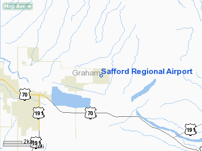
| Serves |
Safford, Arizona |
| Elevation AMSL |
3,179 ft / 969 m |
| Coordinates |
32°51′12″N 109°38′06″W / 32.85333°N 109.635°W / 32.85333; -109.635 |
| Runways |
| Direction |
Length |
Surface |
| ft |
m |
| 12/30 |
6,006 |
1,831 |
Asphalt |
| 8/26 |
4,800 |
1,463 |
Asphalt |
| Helipads |
| Number |
Length |
Surface |
| ft |
m |
| H1 |
72 |
22 |
Concrete |
| Statistics (2009) |
| Aircraft operations |
8,690 |
| Based aircraft |
32 |
| Source: Federal Aviation Administration |
Safford Regional Airport (IATA: SAD, ICAO: KSAD, FAA LID: SAD) is a city-owned public-use airport located three nautical miles (6 km) east of the central business district of Safford, a city in Graham County, Arizona, United States. The airport is included in the FAA's National Plan of Integrated Airport Systems for 2009–2013, which categorizes it as a general aviation facility. It is the only paved airport in Graham County. History
Originally the Civilian Pilot Training Airport or Wickersham Airport was 3 miles (4.8 km) south of Safford, where the fairgrounds are today. Safford Regional Airport as we know it was built as a military auxiliary field during World War II. On November 11, 1941, a 20-year lease for the airport site was given to the City of Safford by the U.S. Government. By March 8, 1946 the airport site was transferred to the City of Safford on a permanent basis.
- 1949: Land acquisition, construction of access road and cattle guard, fencing.
- 1950: Installation of medium intensity runway lighting (MIRL) on NE/SW runway, modification of lighting service and control segmented circle and lighted wind cone, construction of curbs for auto parking, fencing. Installation of 10-inch (250 mm) clear- green rotating beacon.
- 1952: Construct water supply and distribution system, convert single phase electrical system to 3 phase.
- 1974: Overlay and mark Runway 12/30 (approximately 4,800 feet (1,500 m) by 75 feet) and taxiway (approximately 2,800 feet (850 m) by 40 feet); pave aircraft parking apron (approximately 22,000 sq yd).
- 1981: Install MIRL; 12/30. Construction of parking Apron.
- 1983: Construct medium intensity taxiway lighting (MITL), place guidance signs and mark parallel taxiway (approximately 370 feet (110 m) by 35 feet), install Visual Approach Slope Indicators (VASI-2) and runway edge identifier lights (REIL), runway ends 12/30. Grading, drainage and surfacing of taxiway 12/30.
- 1986: Slurry seal runway 12/30.
- 1987: Reconstruct and mark runway 8/26 (approximately 75 feet (23 m) by 4,800 feet), mark taxiway hold lines and grade 200 by 125 feet (38 m) at both ends of the runway.
- 1992: Extend taxiway B to runway 12/30 eastern end, crack seal and overlay existing taxiway A and B, install MITL along Taxiway C and extend taxiway B.
- 1994: Reconstruct runway 12/30 excluding recent extension and construction of terminal parking lot.
- 1995: Pave auto parking lot.
- 1996: Reconstruct and expand existing terminal apron.
- 1997: ASOS Weather Station installed.
- 1998: Construct heliport, provide runway 8/26 pavement and airport fencing.
Facilities and aircraft
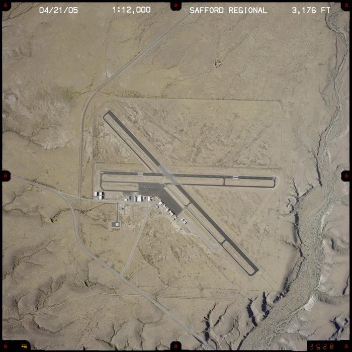
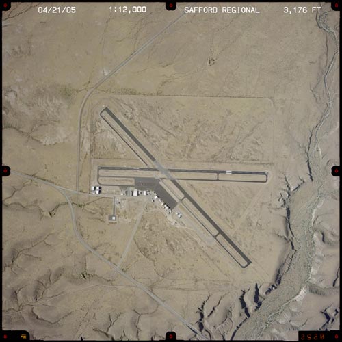
Safford Regional Airport covers an area of 630 acres (255 ha) at an elevation of 3,179 feet (969 m) above mean sea level. It has two asphalt paved runways: 12/30 is 6,006 by 100 feet (1,831 x 30 m) and 8/26 is 4,800 by 75 feet (1,463 x 23 m). It also has one helipad designated H1 with a 72 by 72 ft (22 x 22 m) concrete surface.
For the 12-month period ending March 31, 2009, the airport had 8,690 aircraft operations, an average of 23 per day: 93% general aviation, 7% military and <1% air taxi. At that time there were 32 aircraft based at this airport: 56% single-engine, 41% multi-engine and 3% helicopter.
Operations
- Sectional chart:PHOENIX
- Control tower:no
- ARTCC:ALBUQUERQUE CENTER
- FSS:PRESCOTT FLIGHT SERVICE STATION [1-866-226-3763]
- NOTAMs facility:SAD (NOTAM-D service available)
- Attendance:MON-SAT 0700-1730, SUN 0700-1530
- Pattern altitude:4,177 ft (1,273 m) MSL
- Wind indicator:lighted
- Segmented circle:yes
- Lights:DUSK-DAWN
- Beacon:white-green (lighted land airport)
Communications
- CTAF/UNICOM:122.8
- WX ASOS:124.175 (928-428-5178)
- APCH/DEP SERVICE PRVDD BY ALBUQUERQUE ARTCC ON FREQS 134.45/327.15 (SILVER CITY RCAG).
Services
- Fuel available:100LL JET-A
- FUEL AVBL AFTER HRS CTC (928) 552-0543.
- Parking:tiedowns
- Airframe service:MAJOR
- Powerplant service:MAJOR
- Bottled oxygen:NONE
- Bulk oxygen:NONE
The above content comes from Wikipedia and is published under free licenses – click here to read more.
Location & QuickFacts
|
FAA
Information Effective: |
2005-10-27 |
|
Airport Identifier: |
SAD |
|
Longitude/Latitude: |
109-38-05.8950W/32-51-11.9260N
-109.634971/32.853313 (Estimated) |
|
Elevation: |
3177 ft / 968.35 m (Surveyed) |
|
Land: |
630 acres |
|
From nearest city: |
3
nautical miles E of Safford, AZ |
|
Location: |
Graham County, AZ |
|
Magnetic Variation: |
12E (1985) |
Owner & Manager
|
Ownership: |
Publicly owned |
|
Owner: |
City Of Safford
ROBERT PORTER; PUBLIC WORKS DIRECTOR. |
|
Address: |
717 Main St
Safford, AZ 85546 |
|
Phone number: |
520-428-2762 |
|
Manager: |
Doug Benson |
|
Address: |
4550 E Aviation Way
Safford, AZ 85546 |
|
Phone number: |
520-428-7670 |
Airport Operations and Facilities
|
Airport
Use: |
Open to public |
|
Wind indicator: |
Yes |
|
Segmented Circle: |
Yes |
|
Control Tower: |
No |
|
Attendance Schedule: |
ALL/MON-SAT/0700-1730,ALL/SUN/0700-1530 |
|
Lighting Schedule: |
DUSK-DAWN |
|
Beacon Color: |
Clear-Green (lighted land airport) |
|
Landing fee charge: |
No |
|
Sectional chart: |
Phoenix |
|
Region: |
AWP - Western-Pacific |
|
Traffic Pattern
Alt: |
1000 ft |
|
Boundary ARTCC: |
ZAB - Albuquerque |
|
Tie-in FSS: |
PRC - Prescott |
|
FSS on Airport: |
No |
|
FSS Phone: |
928-778-7810 |
|
FSS Toll Free: |
1-800-WX-BRIEF |
|
NOTAMs Facility: |
SAD (NOTAM-d service avaliable) |
|
Federal Agreements: |
NGSY3 |
Airport Communications
|
CTAF: |
122.800 |
|
Unicom: |
122.800 |
Airport Services
|
Fuel
available: |
100LLA |
|
Airframe
Repair: |
MAJOR |
|
Power
Plant Repair: |
MAJOR |
|
Bottled Oxygen: |
NONE |
|
Bulk Oxygen: |
NONE |
Runway Information
Runway 08/26
|
Dimension: |
4800 x 75 ft /
1463.0 x 22.9 m |
|
Surface: |
ASPH,
Good Condition |
|
Weight Limit: |
Single
wheel: 23000 lbs. |
|
Edge Lights: |
Medium |
|
|
Runway 08 |
Runway 26 |
|
Longitude: |
109-38-35.0100W |
109-37-38.7500W |
|
Latitude: |
32-51-17.3600N |
32-51-17.0900N |
|
Elevation: |
3158.00 ft |
3177.00 ft |
|
Alignment: |
90 |
127 |
|
Traffic Pattern: |
Left |
Left |
|
Markings: |
Basic, Good Condition |
Basic, Good Condition |
|
VASI: |
2-light PAPI on left side |
2-light PAPI on left side |
|
Runway End Identifier: |
No |
No |
|
Centerline Lights: |
No |
No |
|
Touchdown Lights: |
No |
No |
|
Obstruction: |
7
ft fence, 233.0 ft from runway, 4:1 slope to clear |
,
50:1 slope to clear
+6 FT FENCE 145 FT FROM END OF RY. |
|
Runway 12/30
|
Dimension: |
6015 x 100 ft
/ 1833.4 x 30.5 m |
|
Surface: |
ASPH,
Good Condition |
|
Weight Limit: |
Single
wheel: 33000 lbs. |
|
Edge Lights: |
Medium |
|
|
Runway 12 |
Runway 30 |
|
Longitude: |
109-38-33.4800W |
109-37-43.9200W |
|
Latitude: |
32-51-33.9800N |
32-50-51.6400N |
|
Elevation: |
3163.00 ft |
3167.00 ft |
|
Alignment: |
127 |
127 |
|
Traffic Pattern: |
Left |
Left |
|
Markings: |
Basic, Good Condition |
Basic, Good Condition |
|
Crossing Height: |
37.00 ft |
36.00 ft |
|
VASI: |
2-box on left side |
2-box on left side |
|
Visual Glide Angle: |
3.00� |
3.00� |
|
Centerline Lights: |
No |
No |
|
Touchdown Lights: |
No |
No |
|
Obstruction: |
7
ft fence, 425.0 ft from runway, 32:1 slope to clear |
,
50:1 slope to clear |
|
Helipad H1
|
Dimension: |
72 x 72 ft / 21.9
x 21.9 m |
|
Surface: |
CONC,
|
|
|
Runway H1 |
Runway |
|
Traffic Pattern: |
Left |
Left |
|
Radio Navigation Aids
|
ID |
Type |
Name |
Ch |
Freq |
Var |
Dist |
|
SSO |
VORTAC |
San
Simon |
101X |
115.40 |
13E |
39.8
nm |
|
CIE |
VORTAC |
Cochise |
105X |
115.80 |
13E |
49.7
nm |
Remarks
-
MILITARY TFC NEAR AIRPORT.
-
TFC INVOF AGRICULTURE
STRIP ONE MILE SW OF ARPT.
-
ESTABD PRIOR TO 5/15/59.
Based Aircraft
|
Aircraft
based on field: |
29 |
|
Single Engine Airplanes: |
21 |
|
Multi Engine Airplanes: |
7 |
|
Ultralights: |
1 |
Operational Statistics
|
Aircraft
Operations: |
272/Week |
|
Air Taxi: |
8.5% |
|
General Aviation
Local: |
20.1% |
|
General Aviation
Itinerant: |
56.0% |
|
Military: |
15.3% |
Safford Regional Airport
Address:
Graham County,
AZ
Tel:
520-428-2762,
520-428-7670
|
 |
(Click on the image to enlarge) |
Images and information placed above are from
http://www.airport-data.com/airport/SAD/
http://www.dot.state.az.us/aviation/airports/airports_list.asp?FAA=SAD
We thank them for the data!
| General
Info |
| Country |
United
States |
| State |
ARIZONA
|
| FAA ID |
SAD |
| Latitude |
32-51-11.926N
|
| Longitude |
109-38-05.895W
|
| Elevation |
3177 feet
|
| Near City |
SAFFORD
|
We don't guarantee the information is fresh and accurate. The data may be wrong or outdated.
For more up-to-date information please refer to other sources.
|
|