|
|
Ryan Airfield
 |
| IATA: none – ICAO: KRYN – FAA LID: RYN |
| Summary |
| Airport type |
Public |
| Owner |
City of Tucson |
| Operator |
Tucson Airport Authority |
| Serves |
Tucson, Arizona |
| Location |
Pima County, Arizona |
| Elevation AMSL |
2,417 ft / 737 m |
| Coordinates |
32°08′32″N 111°10′28″W / 32.14222°N 111.17444°W / 32.14222; -111.17444 |
| Runways |
| Direction |
Length |
Surface |
| ft |
m |
| 6L/24R |
4,900 |
1,494 |
Asphalt |
| 6R/24L |
5,500 |
1,676 |
Asphalt |
| 15/33 |
4,000 |
1,219 |
Asphalt |
| Statistics (2006) |
| Aircraft operations |
165,246 |
| Based aircraft |
261 |
| Source: Federal Aviation Administration |
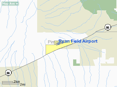
Ryan Airfield (ICAO: KRYN, FAA LID: RYN), also known as Ryan Field Airport, is a public airport located 10 miles (16 km) southwest of the central business district of Tucson, a city in Pima County, Arizona, United States. According to the FAA's National Plan of Integrated Airport Systems for 2007–2011, it is categorized as a reliever airport.
It is mostly used for general aviation but also serves a significant amount of law enforcement and military helicopter activity. Approximately 50% of Ryan's traffic is training-related. Annual operations for 2007 totaled 249,523, an increase of 23% over 2006. Although most U.S. airports use the same three-letter location identifier for the FAA and IATA, Ryan Airfield is assigned RYN by the FAA but has no designation from the IATA (which assigned RYN to Royan - Médis Airport in Royan, France). History
Ryan was built by the United States Army Air Forces in 1942 as a site for primary flight training. Military flight training at Ryan ceased in 1944 and the property was conveyed to the State of Arizona in 1948. Currently owned by the City of Tucson, Ryan is operated by the Tucson Airport Authority under an agreement which expires in 2054.
An air traffic control tower was constructed at Ryan in 1993. The airport was added to the Contract Tower Program in 1996. In September 2004 the tower staff completed the 1 millionth operation without an error.
Significant infrastructure improvements and major maintenance projects are accomplished continuously, as is private and commercial hangar construction.
Facilities and aircraft
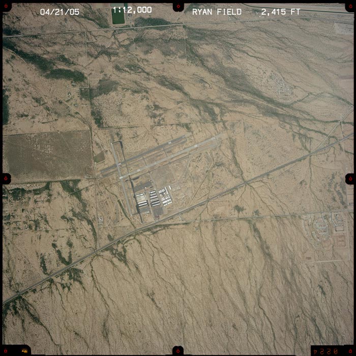
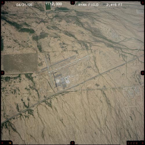
Ryan Field covers an area of 1,754 acres (710 ha) which contains three asphalt paved runways:
- Runway 6L/24R: 4,900 x 75 ft (1,494 x 23 m)
- Runway 6R/24L: 5,500 x 75 ft (1,676 x 23 m)
- Runway 15/33: 4,000 x 75 ft (1,219 x 23 m)
Only runway 6R is serviced by an instrument approach. It allows pilots to land with ceilings as low as 250 feet above ground level. Runways 6L and 6R are the preferential runways, and they are used with tailwinds up to 10 knots. For the 12-month period ending December 30, 2007, the airport had 249,523 aircraft operations, an average of 683 per day: 97% general aviation, 3% military and <1% air taxi. There are 305 aircraft based at this airport, as of early 2008: 90% single-engine, 7% multi-engine, 2% glider, 2% ultralight, <1% jet and <1% helicopter.
The above content comes from Wikipedia and is published under free licenses – click here to read more.
|
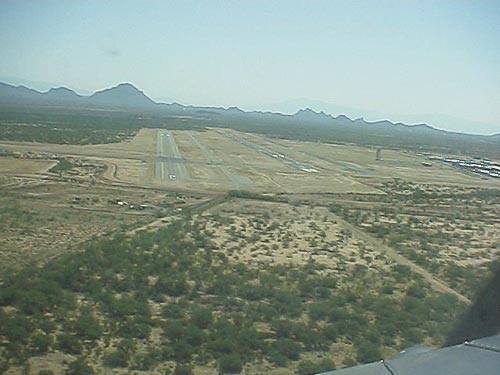 |
On Final to runway 6
(Click on the image to enlarge)
|
Location & QuickFacts
|
FAA
Information Effective: |
2005-10-27 |
|
Airport Identifier: |
RYN |
|
Longitude/Latitude: |
111-10-28.4750W/32-08-31.9790N
-111.174576/32.142216 (Estimated) |
|
Elevation: |
2417 ft / 736.70 m (Surveyed) |
|
Land: |
1754 acres |
|
From nearest city: |
10 nautical miles SW of Tucson, AZ |
|
Location: |
Pima County, AZ |
|
Magnetic Variation: |
12E (1985) |
|
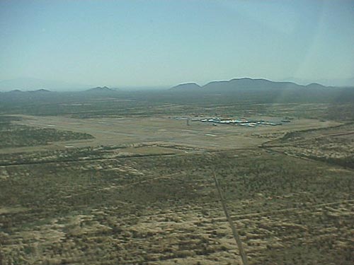 |
Looking southeast at the airport
(Click on the image to enlarge)
|
Owner & Manager
|
Ownership: |
Publicly owned |
|
Owner: |
City Of Tucson Arpt Auth |
|
Address: |
7005 S. Plumer
Tucson, AZ 85706 |
|
Phone number: |
520-573-8100 |
|
Manager: |
Scott R. Driver |
|
Address: |
7005 S. Plumer
Tucson, AZ 85706 |
|
Phone number: |
520-883-9800 |
Airport Operations and Facilities
|
Airport
Use: |
Open to public |
|
Wind indicator: |
Yes |
|
Segmented Circle: |
Yes |
|
Control Tower: |
Yes |
|
Attendance Schedule: |
ALL/ALL/0600-2000 |
|
Lighting Schedule: |
DUSK-DAWN |
|
Beacon Color: |
Clear-Green (lighted land airport) |
|
Landing fee charge: |
No |
|
Sectional chart: |
Phoenix |
|
Region: |
AWP - Western-Pacific |
|
Traffic Pattern
Alt: |
800 ft |
|
Boundary ARTCC: |
ZAB - Albuquerque |
|
Tie-in FSS: |
PRC - Prescott |
|
FSS on Airport: |
No |
|
FSS Phone: |
928-778-7810 |
|
FSS Toll Free: |
1-800-WX-BRIEF |
|
NOTAMs Facility: |
PRC (NOTAM-d service avaliable) |
|
Federal Agreements: |
NGPY |
Airport Communications
Airport Services
|
Fuel
available: |
100LLA
SELF SERVICE FUEL AVBL 24 HRS. |
|
Airframe
Repair: |
MAJOR |
|
Power
Plant Repair: |
MAJOR |
|
Bottled Oxygen: |
NONE |
|
Bulk Oxygen: |
NONE |
Runway Information
Runway 06L/24R
|
Dimension: |
4900
x 75 ft / 1493.5 x 22.9 m |
|
Surface: |
ASPH,
Good Condition |
|
Weight Limit: |
Single
wheel: 12500 lbs.
Dual wheel: 30000 lbs. |
|
|
Runway 06L |
Runway 24R |
|
Longitude: |
111-10-56.9783W |
111-10-03.3273W |
|
Latitude: |
32-08-28.3964N |
32-08-44.7309N |
|
Elevation: |
2393.00 ft |
2396.00 ft |
|
Alignment: |
70 |
127 |
|
Traffic Pattern: |
Left |
Left |
|
Markings: |
Basic, Good Condition |
Non-precision instrument, Good Condition |
|
Runway 06R/24L
|
Dimension: |
5500
x 75 ft / 1676.4 x 22.9 m |
|
Surface: |
ASPH,
Good Condition |
|
Weight Limit: |
Single
wheel: 12500 lbs.
Dual wheel: 30000 lbs. |
|
Edge Lights: |
Medium |
|
|
Runway 06R |
Runway 24L |
|
Longitude: |
111-10-45.4922W |
111-09-45.2678W |
|
Latitude: |
32-08-24.5444N |
32-08-42.8717N |
|
Elevation: |
2398.00 ft |
2403.00 ft |
|
Alignment: |
70 |
127 |
|
ILS Type: |
ILS/DME |
|
|
Traffic Pattern: |
Left |
Left |
|
Markings: |
Precision instrument, Good Condition |
Non-precision instrument, Good Condition |
|
Crossing Height: |
0.00 ft |
26.00 ft |
|
VASI: |
|
4-box on left side |
|
Visual Glide Angle: |
0.00� |
3.00� |
|
Runway End Identifier: |
Yes
REIL RY 06R OPER DAYLGT HRS ONLY. |
|
|
Runway 15/33
|
Dimension: |
4000
x 75 ft / 1219.2 x 22.9 m |
|
Surface: |
ASPH,
Fair Condition |
|
|
Runway 15 |
Runway 33 |
|
Longitude: |
111-10-49.5050W |
111-10-39.3480W |
|
Latitude: |
32-08-43.2960N |
32-08-04.6710N |
|
Elevation: |
2384.00 ft |
2416.00 ft |
|
Alignment: |
127 |
127 |
|
Traffic Pattern: |
Left |
Left |
|
Radio Navigation Aids
|
ID |
Type |
Name |
Ch |
Freq |
Var |
Dist |
|
RYN |
NDB |
Ryan |
|
338.00 |
12E |
0.7
nm |
|
RBJ |
NDB |
Robles |
|
220.00 |
12E |
10.3
nm |
|
AVQ |
NDB |
Marana |
|
245.00 |
12E |
16.3
nm |
|
ENZ |
NDB |
Nogales |
|
394.00 |
12E |
46.5
nm |
|
DMA |
TACAN |
Davis
Monthan |
123X |
|
12E |
15.0
nm |
|
OLS |
VOR/DME |
Nogales |
019X |
108.20 |
12E |
46.8
nm |
|
TUS |
VORTAC |
Tucson |
107X |
116.00 |
12E |
13.5
nm |
Remarks
-
RY 06R AND RY 06L PREFERENTIAL
RY UP TO 10 KNOT TAILWIND.
-
REFLECTOR MARKERS ON
ALL TWYS.
-
RY 24L 8 FT BRUSH WITHIN
PRIMARY SFC NORTH SIDE.
Based Aircraft
|
Aircraft
based on field: |
255 |
|
Single Engine Airplanes: |
234 |
|
Multi Engine Airplanes: |
17 |
|
Jet Engine Airplanes: |
2 |
|
Helicopters: |
2 |
Operational Statistics
|
Aircraft
Operations: |
436/Day |
|
General Aviation
Local: |
67.7% |
|
General Aviation
Itinerant: |
31.6% |
|
Military: |
0.7% |
Ryan Field Airport
Address:
Pima County,
AZ
Tel:
520-573-8100,
520-883-9800
|
 |
(Click on the image to enlarge) |
Images and information placed above are from
http://www.airport-data.com/airport/RYN/
http://www.dot.state.az.us/aviation/airports/airports_list.asp?FAA=RYN
http://www.airfieldinfo.com/ryan.html
We thank them for the data!
| General
Info |
| Country |
United
States |
| State |
ARIZONA
|
| FAA ID |
RYN |
| Latitude |
32-08-35.100N
|
| Longitude |
111-10-22.300W
|
| Elevation |
2403 feet
|
| Near City |
TUCSON
|
We don't guarantee the information is fresh and accurate. The data may be wrong or outdated.
For more up-to-date information please refer to other sources.
|
|