 |
|
|
|
|
|
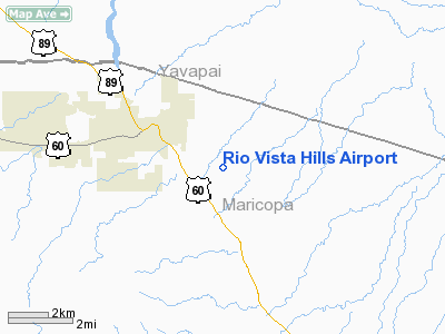
Location & QuickFacts
|
FAA Information
Effective: |
2005-10-27 |
|
Airport Identifier: |
AZ64 |
|
Longitude/Latitude: |
112-41-11.6340W/33-57-08.1100N
-112.686565/33.952253 (Estimated) |
|
Elevation: |
2225 ft / 678.18 m (Estimated) |
|
Land: |
0
acres |
|
From nearest
city: |
3
nautical miles SE of Wickenburg, AZ |
|
Location: |
Maricopa County, AZ |
|
Magnetic Variation: |
13E (1985) |
Owner & Manager
|
Ownership: |
Privately owned |
|
Owner: |
Rio Vista Hills Homeowners |
|
Address: |
10105 E Via Linda 103-189
Scottsdale, AZ 85258-5311 |
|
Phone number: |
602-684-7801 |
|
Manager: |
Stu Sahr |
|
Address: |
P
O Box Q2
Wickenburg, AZ 85358 |
|
Phone number: |
602-684-7801 |
Airport Operations
and Facilities
|
Airport Use: |
Private |
|
Wind indicator: |
Yes |
|
Segmented
Circle: |
No |
|
Control Tower: |
No |
|
Attendance
Schedule: |
UNATNDD |
|
Landing fee
charge: |
No |
|
Sectional
chart: |
Phoenix |
|
Region: |
AWP - Western-Pacific |
|
Boundary ARTCC: |
ZAB - Albuquerque |
|
Tie-in FSS: |
PRC - Prescott |
|
FSS on Airport: |
No |
|
FSS Phone: |
928-778-7810 |
|
FSS Toll Free: |
1-800-WX-BRIEF |
Runway Information
Runway 01/19
|
Dimension: |
2500 x 75
ft / 762.0 x 22.9 m |
|
Surface: |
DIRT,
|
|
|
Runway 01 |
Runway 19 |
|
Traffic Pattern: |
Left |
Left |
|
Radio Navigation Aids
|
ID |
Type |
Name |
Ch |
Freq |
Var |
Dist |
|
SDL |
NDB |
Scottsdale |
|
224.00 |
12E |
43.5
nm |
|
LUF |
TACAN |
Luke |
077X |
|
13E |
29.2
nm |
|
BXK |
VORTAC |
Buckeye |
043X |
110.60 |
14E |
30.8
nm |
|
DRK |
VORTAC |
Drake |
088X |
114.10 |
14E |
46.2
nm |
|
PXR |
VORTAC |
Phoenix |
103X |
115.60 |
12E |
47.5
nm |
|
PRC |
VOT |
Prescott |
|
110.00 |
|
44.1
nm |
|
PHX |
VOT |
Phoenix
Sky Harbor |
|
109.00 |
|
46.0
nm |
Remarks
Based Aircraft
|
Aircraft based
on field: |
2 |
|
Single Engine
Airplanes: |
1 |
|
Multi Engine
Airplanes: |
1 |
Rio Vista Hills Airport
Address:
Maricopa County,
AZ
Tel:
602-684-7801
Images and information placed above are from
http://www.airport-data.com/airport/AZ64/
We
thank them for the data!
| General
Info |
| Country |
United
States |
| State |
ARIZONA
|
| FAA ID |
AZ64 |
| Latitude |
33-57-08.110N
|
| Longitude |
112-41-11.634W
|
| Elevation |
2225 feet
|
| Near City |
WICKENBURG
|
We don't guarantee the information is fresh and accurate. The data may be wrong or outdated.
For more up-to-date information please refer to other sources.
|
|


