 |
|
|
|
|
|

Location & QuickFacts
|
FAA Information
Effective: |
2005-10-27 |
|
Airport Identifier: |
P48 |
|
Longitude/Latitude: |
112-15-02.5750W/33-48-02.1280N
-112.250715/33.800591 (Estimated) |
|
Elevation: |
1580 ft / 481.58 m (Estimated) |
|
Land: |
100 acres |
|
From nearest
city: |
0
nautical miles N of Peoria, AZ |
|
Location: |
Maricopa County, AZ |
|
Magnetic Variation: |
13E (1985) |
Owner & Manager
|
Ownership: |
Privately owned |
|
Owner: |
Pleasant Valley Airport Assoc |
|
Address: |
2532 N. Saffron
Mesa, AZ 85215
CARE OF WALLACE O. TANNER. |
|
Phone number: |
480-854-0750
C/O WALLACE O. TANNER |
|
Manager: |
Roy M Coulliette |
|
Address: |
8700 W Carefree Hwy
Peoria, AZ 85382 |
|
Phone number: |
602-439-3621 |
Airport Operations
and Facilities
|
Airport Use: |
Private |
|
Wind indicator: |
Yes |
|
Segmented
Circle: |
Yes |
|
Control Tower: |
No |
|
Attendance
Schedule: |
ALL/ALL/ALL |
|
Landing fee
charge: |
No |
|
Sectional
chart: |
Phoenix |
|
Region: |
AWP - Western-Pacific |
|
Boundary ARTCC: |
ZAB - Albuquerque |
|
Tie-in FSS: |
PRC - Prescott |
|
FSS on Airport: |
No |
|
FSS Phone: |
928-778-7810 |
|
FSS Toll Free: |
1-800-WX-BRIEF |
|
NOTAMs Facility: |
PRC (NOTAM-d service avaliable) |
Airport Communications
Airport Services
|
Fuel available: |
100LL |
|
Airframe Repair: |
MINOR |
|
Power Plant
Repair: |
MINOR |
|
Bottled Oxygen: |
LOW |
Runway Information
Runway 05C/23C
|
Dimension: |
4200 x 100
ft / 1280.2 x 30.5 m |
|
Surface: |
DIRT,
|
|
|
Runway 05C |
Runway 23C |
|
Traffic Pattern: |
Left |
Left |
|
Displaced threshold: |
490.00 ft |
200.00 ft |
|
Obstruction: |
15
ft road |
24
ft pline, 974.0 ft from runway, 40:1 slope to clear |
|
Runway 05L/23R
|
Dimension: |
4200 x 100
ft / 1280.2 x 30.5 m |
|
Surface: |
DIRT,
|
|
|
Runway 05L |
Runway 23R |
|
Traffic Pattern: |
Right |
Right |
|
Displaced threshold: |
480.00 ft |
63.00 ft |
|
Obstruction: |
15
ft road |
24
ft pline, 849.0 ft from runway, 35:1 slope to clear |
|
Runway 05R/23L
|
Dimension: |
4200 x 100
ft / 1280.2 x 30.5 m |
|
Surface: |
DIRT,
|
|
|
Runway 05R |
Runway 23L |
|
Traffic Pattern: |
Left |
Left |
|
Displaced threshold: |
580.00 ft |
240.00 ft |
|
Obstruction: |
15
ft road |
24
ft pline, 1124.0 ft from runway, 46:1 slope to clear |
|
Runway 14/32
|
Dimension: |
2400 x 100
ft / 731.5 x 30.5 m |
|
Surface: |
DIRT,
|
|
|
Runway 14 |
Runway 32 |
|
Traffic Pattern: |
Left |
Left |
|
Displaced threshold: |
0.00 ft |
300.00 ft |
|
Obstruction: |
6
ft brush, 100.0 ft from runway, 50 ft left of centerline,
16:1 slope to clear |
15
ft road, 0.0 ft from runway |
|
Radio Navigation Aids
|
ID |
Type |
Name |
Ch |
Freq |
Var |
Dist |
|
SDL |
NDB |
Scottsdale |
|
224.00 |
12E |
20.0 nm |
|
FFZ |
NDB |
Falcon
Field |
|
281.00 |
12E |
33.0 nm |
|
CHD |
NDB |
Chandler |
|
407.00 |
12E |
39.0 nm |
|
LUF |
TACAN |
Luke |
077X |
|
13E |
17.1 nm |
|
PXR |
VORTAC |
Phoenix |
103X |
115.60 |
12E |
26.2 nm |
|
BXK |
VORTAC |
Buckeye |
043X |
110.60 |
14E |
35.5 nm |
|
IWA |
VORTAC |
Willie |
080X |
113.30 |
13E |
42.4 nm |
|
PHX |
VOT |
Phoenix
Sky Harbor |
|
109.00 |
|
25.1 nm |
Remarks
-
AEROBATIC ACTIVITY ON & INVOF
ARPT.
-
EXTENSIVE GLIDER AND
ULTRALIGHT ACTIVITY ON AND INVOF OF ARPT.
-
CTC FBO ON 122.9
-
ALL RYS SOFT AND SLIPPERY WHEN
WET.
-
GLIDERS FLY DOWNWIND ON SOUTH
SIDE OF ARPT AND POWER UP ON NORTH SIDE.
-
BLDG AND PARKED ACFT LCTD 120
FT SOUTH OF RY 05R/23L APPROX MIDPOINT.
-
DSPLCD THLDS ON ALL RYS MKD
WITH WHITE CHALK AND SMALL WHITE TIRES.
-
SHALLOW UNDERGROUND GAS
PIPELINE LCTD 240 FT FM EOR 23L, 23C, AND 23R.
-
RY SEPARATIONS DO NOT MEET
MINIMUM STDS, SIMULTANEOUS OPNS NOT AUTH ON ANY TWO RYS.
-
PRVDD PILOTS USING ARPT ARE
THROUGHLY BRIEFED ON PR0XIMITY OF VFR LOW ALT TRAINING RTES.
Based Aircraft
|
Aircraft based on field: |
61 |
|
Single Engine Airplanes: |
11 |
|
Multi Engine Airplanes: |
1 |
|
Gliders: |
34 |
|
Ultralights: |
15 |
Operational Statistics
|
Aircraft Operations: |
209/Day |
|
Air Taxi: |
1.6% |
|
General Aviation Local: |
78.7% |
|
General Aviation Itinerant: |
19.7% |
Pleasant Valley Airport
Address:
Maricopa County, AZ
Tel:
480-854-0750,
602-439-3621
|
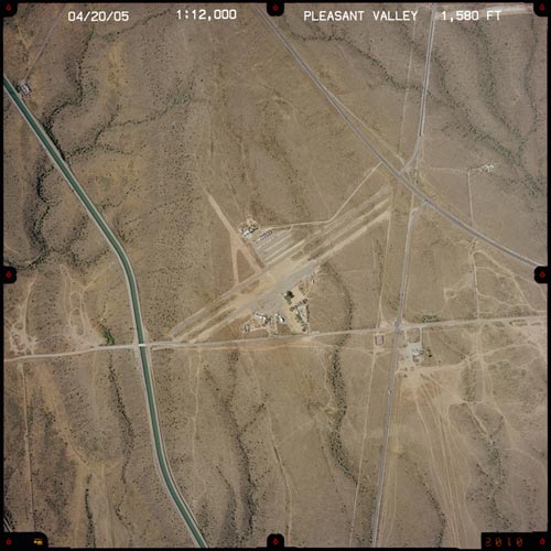 |
(Click on the photo
to enlarge) |
Images and information placed above are from
http://www.airport-data.com/airport/P48/
http://www.azdot.gov/aviation/airports/airports_list.asp?FAA=P48
We
thank them for the data!
| General
Info |
| Country |
United
States |
| State |
ARIZONA
|
| FAA ID |
P48 |
| Latitude |
33-48-02.128N
|
| Longitude |
112-15-02.575W
|
| Elevation |
1580 feet
|
| Near City |
PEORIA
|
We don't guarantee the information is fresh and accurate. The data may be wrong or outdated.
For more up-to-date information please refer to other sources.
|
|


