|
 |
|
||||
|
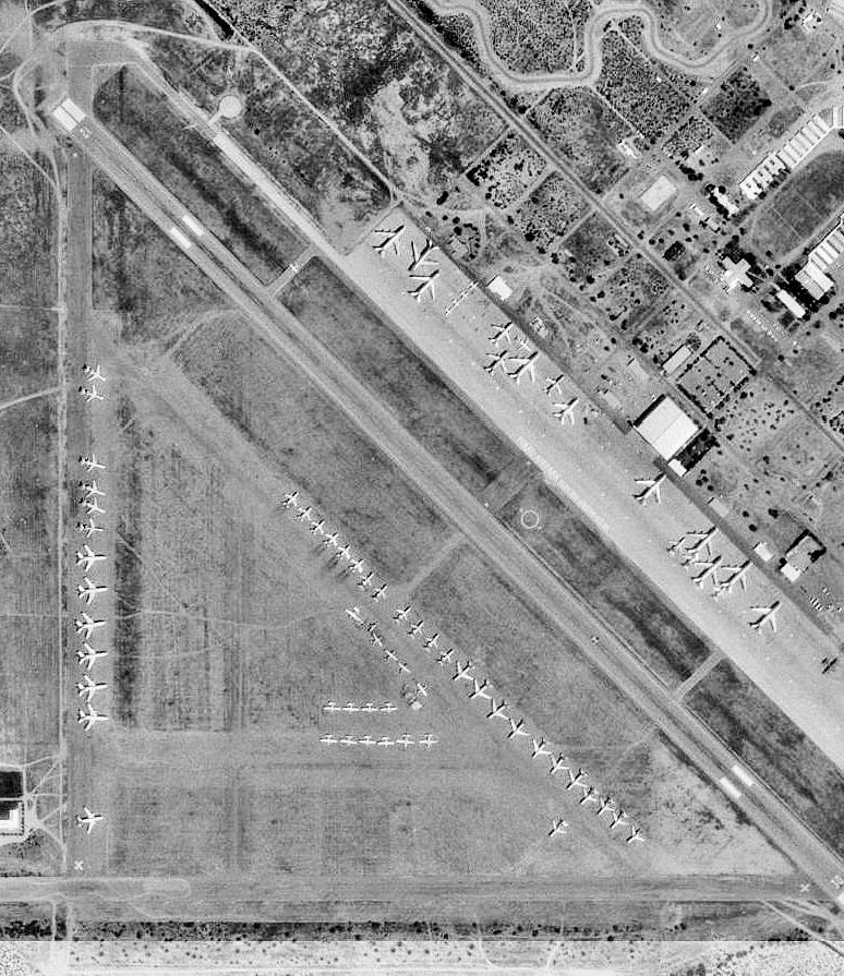
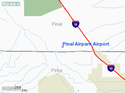
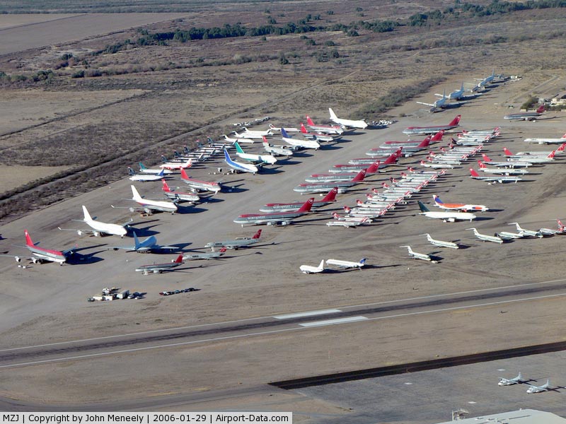
Pinal Airpark (IATA: MZJ, ICAO: KMZJ, FAA LID: MZJ) is a county-owned, public-use airport located seven nautical miles (13 km) northwest of the central business district of Marana, in Pinal County, Arizona, United States. Its main purpose is to act as a "boneyard" for civilian commercial aircraft. Old airplanes are stored there with the hope that the dry desert climate will prevent any form of corrosion in case the aircraft is pressed into service in the future. Even so, many aircraft which are brought there wind up being scrapped. Nearby the 309th Aerospace Maintenance and Regeneration Group at Davis-Monthan Air Force Base provides the same service to the U.S. military. The majority of the aircraft at Pinal Airpark formerly belonged to Northwest Airlines, though many other airlines are represented as well. HistoryBuilt in 1942 by the Sundt & Del Webb Construction Companies and opened in March, 1943, the facility was known as Marana Army Air Field. During World War II, the airfield was under the command of the 389th Army Air Force Base Unit, AAF West Coast Training Center and used as a training base, as part of the 50,000 Pilot Training Program. Marana conducted basic flight training & the training of transport pilots in instrument flying & navigation, being the home of the 3024th (Pilot School, Basic). Chinese pilots were also trained there. Five satellite airfields were established for Marana during WW2: Picacho Aux #1, Rillito Aux #2 (currently reused as Marana Northwest Regional Airport), Coronado Aux #3, Avra Aux #4, and Sahuaro Aux #5 (currently El Tiro Gliderport). The infrastructure installed at Marana during World War II was extensive. This included water, sewer, and gas systems that were still used until some problems developed in the 1990s. There was also a massive storm drain system. The airfield also had a railroad spur line & railroad station. Marana was closed after World War II and in 1948, Pinal County accepted a deed to the property, subsequent to the Air Force's disposal of most of the buildings, waterlines, gas lines, and electrical lines. From 1948-51, Pinal County leased the property to multiple tenants, and from 1951–56, Marana was reused as a contractor-operated USAF flying school, operated by Darr Aeronautical Technical Company. Marana became the headquarters of all Central Intelligence Agency air operations during the Vietnam War years, when it was the primary facility of Intermountain Airlines, a wholly owned CIA "front" company which was used to supply covert operations in Southeast Asia & elsewhere. Intermountain was infamous for its thinly veiled CIA special ops which included development & use of the Fulton Skyhook, but its cover was its non-scheduled freight & maintenance operations. Marana was the principal continental United States maintenance base for Southeast Asia CIA operations including Air America and Continental Air Services. Two of the more notable aircraft assigned to Marana during its CIA years was a Lockheed/Vega B-17G Flying Fortress, AAF Serial 44-85531. 531 was registered September 1957 to Western Enterprises, Inc. of Taiwan (founded by the CIA in 1951). In late 1957 missions were staged from Kurmitola Air Field in East Pakistan (now Bangladesh) to parachute agents into Tibet. The aircraft was disassembled for parts at Clark Air Base, Philippines between March and October 1958, and it is believed that this plane was eventually scrapped. The serial number 44-85531 appeared again as registered on another B-17G, September 1, 1960 registered to Atlantic General Enterprise, Washington DC (another CIA front) as N809Z. These registration numbers were then changed to the true numbers of 44-83785. Based again at Marana, this aircraft later flew black operations over Vietnam and was used to retrieve two American agents from an abandoned Soviet scientific base in the Arctic using the Fulton Skyhook in Operation Coldfeet. Current usagePinal Airpark is the home of Evergreen Aircraft Maintenance Facility and Silverbell Army Heliport (SAHP). The Western Army National Guard Aviation Training Site (WAATS) and other numerous National Guard units are located inside SAHP. The WAATS and is used principally for all ARNG AH-64 Apache Attack Helicopter training by the 'Gunfighter University'. It is also extensively used by the British Army for 'Conversion To Role' training for Apache combat operations in Afghanistan. Pinal Airpark also hosts the U.S. Special Operations Command's Parachute Training and Testing Facility. Facilities and aircraftPinal Airpark covers an area of 2,080 acres (842 ha) at an elevation of 1,893 feet (577 m) above mean sea level. It has one runway designated 12/30 with an asphalt surface measuring 6,849 by 150 feet (2,088 x 46 m). For the 12-month period ending January 31, 2004, the airport had 10,628 aircraft operations, an average of 29 per day: 69% general aviation and 31% military. The above content comes from Wikipedia and is published under free licenses – click here to read more.
Location & QuickFacts
Owner & Manager
Airport Operations and Facilities
Airport Communications
Airport Services
Runway Information Runway 12/30
Radio Navigation Aids
Remarks
Operational Statistics
Pinal Airpark Airport Address: Pinal County, AZ Tel: 520-868-5801, 520-682-4181 Images and information placed above are from http://www.airport-data.com/airport/MZJ/
We don't guarantee the information is fresh and accurate. The data may be wrong or outdated. For more up-to-date information please refer to other sources. |
||||||||||||||||||||||||||||||||||||||||||||||||||||||||||||||||||||||||||||||||||||||||||||||||||||||||||||||||||||||||||||||||||||||||||||||||||||||||||||||||||||||||||||||||||||||||||||||||||||||||||||||||||||||||||||||||||||||||||||||||||||||||||||||||||||||||||||||||||||||||||||||||||||

 |
|
Copyright 2004-2026 © by Airports-Worldwide.com, Vyshenskoho st. 36, Lviv 79010, Ukraine Legal Disclaimer |