|
 |
|
||||
|
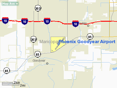
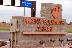
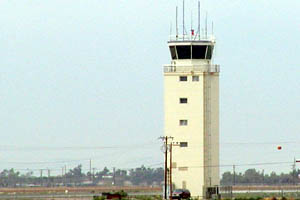
Phoenix Goodyear Airport (IATA: GYR, ICAO: KGYR, FAA LID: GYR), formerly known as Goodyear Municipal Airport, is a public airport located one mile (2 km) southwest of the central business district of Goodyear, in Maricopa County, Arizona, United States. The facility was originally constructed during World War II as a naval air facility known as NAF Litchfield Park, then upgraded to naval air station status and renamed NAS Litchfield Park. Its primary role following the end of World War II was that of storage and preservation of obsolete or excess U.S. Navy, U.S. Marine Corps and U.S. Coast Guard aircraft. In 1968, all Department of Defense and U.S. Coast Guard aircraft preservation and storage was consolidated at the Military Aircraft Storage and Disposition Center (MASDC) at Davis-Monthan AFB in Tucson and NAS Litchfield Park was slated for closure. Following the closure of NAS Litchfield Park in 1968, the city of Phoenix purchased the airport as a general aviation reliever airport for Phoenix Sky Harbor International Airport. The airport is not served by any commercial airlines at this time. Facilities and aircraftPhoenix Goodyear Airport covers an area of 789 acres (319 ha) which contains one asphalt paved runway (3/21) measuring 8,500 x 150 ft (2,591 x 46 m). For the 12-month period ending December 31, 2007, the airport had 188,136 aircraft operations, an average of 515 per day: 93% general aviation, <1% scheduled commercial, 5% military and 1% air taxi. There are 198 aircraft based at this airport: 73% single engine, 11% multi-engine, 16% jet aircraft and <1% helicopters. Resident companiesThe airfield is home to several private companies offering aircraft maintenance and commercial pilot training:
Both of these flight training schools, while regulated by the FAA and operating under their regulations train students to JAA requirements as required for Europe. The above content comes from Wikipedia and is published under free licenses – click here to read more.
About Phoenix Goodyear Airport Goodyear Airport is operated by the city of Phoenix and is located in Goodyear, AZ. It is located 24 miles from Phoenix. From PHX take I-10 West to the Litchfield Road Exit. Go South for several miles to the airport entrance (south of town).
Goodyear Airport is home to numerous light aircraft and many aircraft related businesses. The airport once served as the support facility for the Aircraft Division of Goodyear Tire and Rubber Co. Goodyear Airships has maintained a blimp support facility here for many years, and occasionally an airship could be seen stationed here, usually in the winter months. There are no scheduled services at Goodyear.
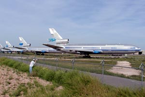
Lufthansa Airlines' Airline Training Center is located at the airport. A large number of aircraft used for training pilots of several airlines can be seen at Goodyear Airport at any given time. TIMCO operates a repair station here, with work being done on a variety of aircraft. Numerous airliners can be seen here, either as stored aircraft or aircraft waiting to be worked on.
Goodyear History Phoenix Goodyear Airport before it became a part of the City of Phoenix airport system was the Goodyear Municipal Airport which had a long history of military service. In 1941, with World War II raging in Europe, the Goodyear Aerospace Corporation offered land to the U.S. Defense Plant Corporation. The U.S. Navy used the land to build aircraft flight decks and established a U.S. Naval Air Facility which would test fly and deliver aircraft. This necessitated the construction of a landing field, hangar and runway. After the war ended, the naval facility remained operational to preserve and store aircraft from 1945 to 1965. At one point, more than 5,000 aircraft were in storage. The airfield became active again in the fifties during the Korean Conflict, but when that ended, the facility was decommissioned. The majority of remaining aircraft were moved to Davis Monthan Air Force Base in Tucson and the U.S. General Service Administration put the entire 800 acre site on its surplus list. In 1968, the City of Phoenix purchased the property to relieve the volume of general aviation aircraft using Phoenix Sky Harbor Airport. A master plan was crafted for the airport in 1986 that called for a new terminal building, hangars and support facilities. To date, Goodyear Airport's improvements have included a new terminal, T-hangars, ramp space, tie downs and an airport maintenance facility. Location & QuickFacts
Owner & Manager
Airport Operations and Facilities
Airport Communications
Airport Services
Runway InformationRunway 03/21
Radio Navigation Aids
Remarks
Based Aircraft
Operational Statistics
Address: Goodyear
Airport Tel: 602-273-3302, 623-932-1200 Images and information placed above are from http://www.airport-data.com/airport/GYR/ http://www.visitingphx.com/goodyear.html http://phoenix.gov/AVIATION/goodyear/index.html We thank them for the data!
We don't guarantee the information is fresh and accurate. The data may be wrong or outdated. For more up-to-date information please refer to other sources. |
||||||||||||||||||||||||||||||||||||||||||||||||||||||||||||||||||||||||||||||||||||||||||||||||||||||||||||||||||||||||||||||||||||||||||||||||||||||||||||||||||||||||||||||||||||||||||||||||||||||||||||||||||||||||||||||||||||||||||||||||||||||||||||||||||||||||||||||||||||||||||||||||||||||||||||||||||||||||||||||||||||||||||||||||||

 |
|
Copyright 2004-2026 © by Airports-Worldwide.com, Vyshenskoho st. 36, Lviv 79010, Ukraine Legal Disclaimer |