 |
|
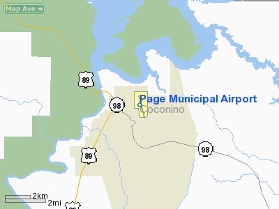
| Page Municipal Airport |
| IATA: PGA – ICAO: KPGA – FAA LID: PGA |
| Summary |
| Airport type |
Public |
| Owner |
City of Page |
| Location |
Page, Arizona |
| Elevation AMSL |
4,316 ft / 1,316 m |
| Coordinates |
36°55′34″N 111°26′54″W / 36.92611°N 111.44833°W / 36.92611; -111.44833 |
| Runways |
| Direction |
Length |
Surface |
| ft |
m |
| 15/33 |
5,950 |
1,814 |
Asphalt |
| 7/25 |
2,201 |
671 |
Asphalt |
| Statistics (2005) |
| Aircraft operations |
19,050 |
| Based aircraft |
78 |
| Source: Federal Aviation Administration |
Page Municipal Airport (IATA: PGA, ICAO: KPGA, FAA LID: PGA) is a public airport located in northeast corner of the city of Page in Coconino County, Arizona, USA. The airport is owned by the City of Page. It is mostly used for general aviation but is also served by one commercial airline. Service is subsidized by the Essential Air Service program. Facilities and aircraft
Page Municipal Airport covers an area of 536 acres (217 ha) which contains two asphalt paved runways: 15/33 measuring 5,950 x 150 ft (1,814 x 46 m) and 7/25 measuring 2,201 x 100 ft (671 x 30 m).
For the 12-month period ending December 31, 2005, the airport had 19,050 aircraft operations, an average of 52 per day: 45% general aviation, 44% air taxi, 11% scheduled commercial and <1% military. There are 78 aircraft based at this airport: 72% single engine, 19% multi-engine, 6% helicopters and 3% jet aircraft.
Airline and destinations
| Airlines |
Destinations |
| Great Lakes Airlines |
Farmington, Phoenix |
- Westwind Air Service (scenic air tours)
The above content comes from Wikipedia and is published under free licenses – click here to read more.
Location & QuickFacts
|
FAA
Information Effective: |
2005-10-27 |
|
Airport Identifier: |
PGA |
|
Longitude/Latitude: |
111-26-54.1000W/36-55-34.0000N
-111.448361/36.926111 (Estimated) |
|
Elevation: |
4313 ft / 1314.60 m (Surveyed) |
|
Land: |
536 acres |
|
From nearest city: |
1
nautical miles E of Page, AZ |
|
Location: |
Coconino County, AZ |
|
Magnetic Variation: |
14E (1980) |
Owner & Manager
|
Ownership: |
Publicly owned |
|
Owner: |
City Of Page |
|
Address: |
Box 1180
Page, AZ 86040 |
|
Phone number: |
928-645-8861 |
|
Manager: |
Richard Jentzsch
AVN DIRECTOR - CITY OF PAGE. |
|
Address: |
Box 1180, 697 Vista Avenue
Page, AZ 86040 |
|
Phone number: |
928-645-4232 |
Airport Operations and Facilities
|
Airport
Use: |
Open to public |
|
Wind indicator: |
Yes |
|
Segmented Circle: |
Yes |
|
Control Tower: |
No |
|
Attendance Schedule: |
ALL/ALL/DALGT |
|
Lighting Schedule: |
DUSK-DAWN
ACTVT MIRL 15/33 - CTAF. VASI RYS 15 & 33 ON CONTINUOUSLY. |
|
Beacon Color: |
Clear-Green (lighted land airport) |
|
Sectional chart: |
Las Vegas |
|
Region: |
AWP - Western-Pacific |
|
Boundary ARTCC: |
ZDV - Denver |
|
Tie-in FSS: |
PRC - Prescott |
|
FSS on Airport: |
No |
|
FSS Phone: |
928-778-7810 |
|
FSS Toll Free: |
1-800-WX-BRIEF |
|
NOTAMs Facility: |
PGA (NOTAM-d service avaliable) |
|
Certification type/date: |
LU 5/1973
CLSD TO AIR CARRIER OPNS WITH MORE THAN 30 PSGR SEATS EXCP PRIOR
PERMISSION CALL AMGR (928) 645-8861. ARFF AVBL 5-7 MIN WITHOUT PPR. |
|
Federal Agreements: |
NGY |
Airport Communications
|
CTAF: |
122.800 |
|
Unicom: |
122.800
UNICOM ADZY AVBL 122.8 SR TO SS ONLY. |
Airport Services
|
Fuel
available: |
100LLA
FOR FUEL AFTER HRS; CTC 928-660-2608 OR 928-645-5356. |
|
Airframe
Repair: |
MAJOR |
|
Power
Plant Repair: |
MAJOR |
|
Bottled Oxygen: |
HIGH/LOW |
|
Bulk Oxygen: |
HIGH |
Runway Information Runway 07/25
|
Dimension: |
2200
x 75 ft / 670.6 x 22.9 m |
|
Surface: |
ASPH,
Good Condition |
|
|
Runway 07 |
Runway 25 |
|
Longitude: |
111-27-12.5800W |
111-26-45.7400W |
|
Latitude: |
36-55-45.0900N |
36-55-48.1000N |
|
Elevation: |
4240.00 ft |
4243.00 ft |
|
Alignment: |
82 |
127 |
|
Traffic Pattern: |
Left |
Right |
|
Markings: |
Basic, |
Numbers only, |
|
Displaced threshold: |
588.00 ft |
0.00 ft |
|
Runway End Identifier: |
No |
No |
|
Centerline Lights: |
No |
No |
|
Touchdown Lights: |
No |
No |
|
Runway 15/33
|
Dimension: |
5499
x 150 ft / 1676.1 x 45.7 m |
|
Surface: |
ASPH,
Good Condition |
|
Weight Limit: |
Single
wheel: 65000 lbs.
Dual wheel: 90000 lbs.
Dual tandem wheel: 190000 lbs. |
|
Edge Lights: |
Medium |
|
|
Runway 15 |
Runway 33 |
|
Longitude: |
111-26-57.8966W |
111-26-46.2748W |
|
Latitude: |
36-55-55.7031N |
36-55-02.1530N |
|
Elevation: |
4246.00 ft |
4313.00 ft |
|
Alignment: |
127 |
127 |
|
Traffic Pattern: |
Left |
Right |
|
Markings: |
Basic, Poor Condition |
Basic, Poor Condition |
|
Runway End Identifier: |
Yes |
Yes |
|
Centerline Lights: |
No |
No |
|
Touchdown Lights: |
No |
No |
|
Radio Navigation Aids
|
ID |
Type |
Name |
Ch |
Freq |
Var |
Dist |
|
PGA |
VOR/DME |
Page |
123X |
117.60 |
13E |
0.3 nm |
|
TBC |
VORTAC |
Tuba
City |
082X |
113.50 |
15E |
49.1 nm |
Remarks
-
USE RWY 07-25 ONLY DURING
PERIODS OF HIGH WINDS FROM EAST OR WEST.
Based Aircraft
|
Aircraft based on field: |
62 |
|
Single Engine Airplanes: |
43 |
|
Multi Engine Airplanes: |
10 |
|
Jet Engine Airplanes: |
2 |
|
Helicopters: |
7 |
Operational Statistics
|
Aircraft Operations: |
46/Day |
|
Air Taxi: |
42.9% |
|
General Aviation Local: |
3.6% |
|
General Aviation Itinerant: |
53.2% |
|
Military: |
0.3% |
Page Municipal Airport
Address: Coconino
County, AZ
Tel:
928-645-8861, 928-645-4232
Images
and information placed above are from
http://www.airport-data.com/airport/PGA/
We
thank them for the data!
| General Info |
| Country |
United
States |
| State |
ARIZONA
|
| FAA ID |
PGA |
| Latitude |
36-55-34.000N
|
| Longitude |
111-26-54.100W
|
| Elevation |
4313 feet
|
| Near City |
PAGE |
We don't guarantee the information is fresh and accurate. The data may be wrong or outdated.
For more up-to-date information please refer to other sources.
|
|


