|
|
Location & QuickFacts
|
FAA
Information Effective: |
2005-10-27 |
|
Airport Identifier: |
AZ82 |
|
Longitude/Latitude: |
110-31-47.4450W/34-23-50.1370N
-110.529846/34.397260 (Estimated) |
|
Elevation: |
6657 ft / 2029.05 m (Surveyed) |
|
Land: |
27 acres |
|
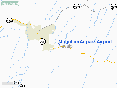
From nearest city: |
1
nautical miles NE of Overgaard, AZ |
|
Location: |
Navajo County, AZ |
|
Magnetic Variation: |
12E (1985) |
Owner & Manager
|
Ownership: |
Privately owned |
|
Owner: |
Mogollon Airpark Inc Hoa |
|
Address: |
Po Box 1778
Overgaard, AZ 85933 |
|
Phone number: |
928-535-3071 |
|
Manager: |
Kenneth E. Wood |
|
Address: |
,
Po Box 280
Overgaard, AZ 85933 |
|
Phone number: |
928-535-6073 |
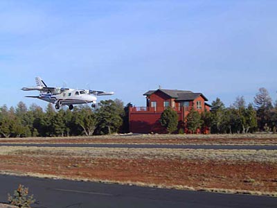
Airport Operations and Facilities
|
Airport
Use: |
Private |
|
Wind indicator: |
Yes |
|
Segmented Circle: |
No |
|
Control Tower: |
No |
|
Attendance Schedule: |
UNATNDD |
|
Landing fee charge: |
No |
|
Sectional chart: |
Phoenix |
|
Region: |
AWP - Western-Pacific |
|
Traffic Pattern
Alt: |
850 ft |
|
Boundary ARTCC: |
ZAB - Albuquerque |
|
Tie-in FSS: |
PRC - Prescott |
|
FSS Phone: |
928-778-7810 |
|
FSS Toll Free: |
1-800-WX-BRIEF |
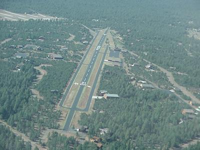
Runway Information
Runway 03/21
|
Dimension: |
3420
x 50 ft / 1042.4 x 15.2 m
RY 03 HAS 700 X 30 FT OVERUN. RY 21 HAS 1200 X 30 FT OVERUN. |
|
Surface: |
ASPH,
|
|
|
Runway 03 |
Runway 21 |
|
Traffic Pattern: |
Left |
Left |
|
VASI: |
|
system of panels on left side that may or may not be lighted
PNIL RY 21 NOT LIGHTED. |
|
Radio Navigation Aids
|
ID |
Type |
Name |
Ch |
Freq |
Var |
Dist |
|
SOW |
NDB |
Show
Low |
|
206.00 |
13E |
27.0
nm |
|
INW |
VORTAC |
Winslow |
073X |
112.60 |
14E |
42.0
nm |
Remarks
-
NO NIGHT OPERATIONS.
-
RY 21 CALM WIND RUNWAY
WHEN WIND IS BELOW 5 KTS.
-
TALL TREES BOTH ENDS
OF RY.
-
TWO-WAY RADIO COMMUNICATIONS
REQUIRED MONITOR FREQ 122.9.
-
RECOMMEND MONITOR KTYL
AWOS-3 ON FREQ 119.075 FOR ARRIVAL WEATHER INFO.
-
BE ALERT TO DENSITY
ALTITUDE WHICH CAN EXCEED 10,000 FT. WIND SHEAR AND TURBULANCE IN HIGH
WIND CONDITIONS.
-
VFR, PRIVATE USE ONLY.
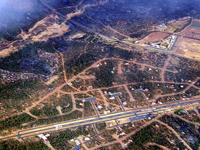
Mogollon Airpark Airport
Address: Navajo
County, AZ
Driving: If you are stuck driving, AZ82 is at mile marker 309 on hwy
260 between Payson and Show Low
Tel
(Manager):
928-535-6073
Contact: Cheri Thomas 928.535.3071
E-mail:
MAPadmin@mogollon.net
URL: http://www.az82.com
Images
and information placed above are from
http://www.airport-data.com/airport/AZ82/
http://www.az82.com
We thank them for
the data!
| General
Info |
| Country |
United
States |
| State |
ARIZONA
|
| FAA ID |
AZ82 |
| Latitude |
34-23-50.137N
|
| Longitude |
110-31-47.445W
|
| Elevation |
6657 feet
|
| Near City |
OVERGAARD
|
We don't guarantee the information is fresh and accurate. The data may be wrong or outdated.
For more up-to-date information please refer to other sources.
|
|