 |
|
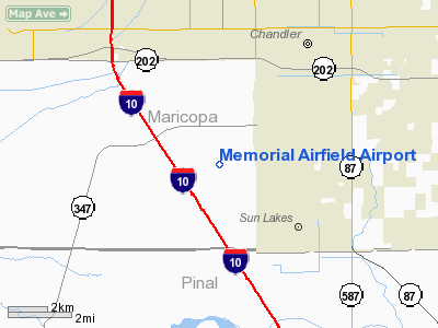
Memorial Airfield Airport |
| Gila River Memorial Airport |
| IATA: none – ICAO: none – FAA LID: 34AZ |
| Summary |
| Airport type |
Private |
| Owner |
Gila River Airport Authority |
| Location |
Chandler, Arizona |
| Elevation AMSL |
1,185 ft / 361.2 m |
| Coordinates |
33°14′36.18″N 111°54′57.105″W / 33.2433833°N 111.9158625°W / 33.2433833; -111.9158625 |
| Runways |
| Direction |
Length |
Surface |
| ft |
m |
| 12/30 |
8,560 x 75 |
2,609 x 23 |
asphalt, good condition |
| 3/21 |
5,200 x 200 |
1585 x 61 |
asphalt, poor condition |
Gila River Memorial Airport (FAA LID: 34AZ) is a private-use airport owned and operated by the Gila River Indian Community, located 4 miles southwest of the central business district of Chandler, in Maricopa County, Arizona, United States. It is used for cropdusting and air charter operations, with no scheduled commercial services.
History
Gila River Memorial Airport was built in 1942 as Williams Auxiliary Army Airfield #5, one of several satellite airfields for Williams Army Airfield. After the war, it was renamed Goodyear Air Force Auxiliary Airfield, with its original triangular configuration modified to accommodate early jet aircraft of the 1950s. During the 1960s, it passed on to civilian control as Goodyear Airport, then as Memorial Airfield. No hangar space existed at the airport until the late 1970s, when the airport began playing host to older piston-engined transport aircraft, many of which had been converted for use as air tankers. By the 1990s, it had become something of an aircraft boneyard.
By 2007, the Gila River Indian Community had assumed control of the airfield, renaming it Gila River Memorial Airport, and all commercial tenants were evicted from the property [1]. In 2008, numerous aircraft were still present, including C-54s, DC-4s, DC-7s, PV-2s , and a Howard 500. [2] Many of them have since been removed, with some of the old airport outbuildings dismantled, with further plans to expand and develop the airport still in progress [3].
The above content comes from Wikipedia and is published under free licenses – click here to read more.
Location & QuickFacts
|
FAA Information
Effective: |
2005-10-27 |
|
Airport Identifier: |
34AZ |
|
Longitude/Latitude: |
111-54-47.1050W/33-14-36.1800N
-111.913085/33.243383 (Estimated) |
|
Elevation: |
1185 ft / 361.19 m (Estimated) |
|
Land: |
1345 acres |
|
From nearest city: |
4
nautical miles SW of Chandler, AZ |
|
Location: |
Maricopa County, AZ |
|
Magnetic Variation: |
13E (1985) |
Owner & Manager
|
Ownership: |
Privately owned |
|
Owner: |
Gila River Indian Community
MEMORIAL AIRPORT CORP. |
|
Address: |
P
O Box 37
Sacaton, AZ 85247 |
|
Manager: |
William W Grantham |
|
Address: |
22000 S. Price Rd
Chandler, AZ 85224 |
|
Phone number: |
602-796-5188 |
Airport Operations and Facilities
|
Airport Use: |
Private |
|
Wind indicator: |
Yes |
|
Segmented Circle: |
No |
|
Control Tower: |
No |
|
Attendance Schedule: |
ALL/MON-FRI/0800-1700 |
|
Landing fee charge: |
No |
|
Sectional chart: |
Phoenix |
|
Region: |
AWP - Western-Pacific |
|
Boundary ARTCC: |
ZAB - Albuquerque |
|
Tie-in FSS: |
PRC - Prescott |
|
FSS on Airport: |
No |
|
FSS Phone: |
928-778-7810 |
|
FSS Toll Free: |
1-800-WX-BRIEF |
Airport Communications
Airport Services
|
Airframe Repair: |
MINOR |
|
Power Plant Repair: |
MINOR |
Runway Information
Runway 03/21
|
Dimension: |
5200
x 200 ft / 1585.0 x 61.0 m |
|
Surface: |
ASPH,
Poor Condition |
|
|
Runway 03 |
Runway 21 |
|
Traffic Pattern: |
Right |
Left |
|
Markings: |
Basic, Poor Condition |
Basic, Poor Condition |
|
Runway End Identifier: |
No |
No |
|
Centerline Lights: |
No |
No |
|
Touchdown Lights: |
No |
No |
|
Obstruction: |
,
50:1 slope to clear |
34
ft pline, 400.0 ft from runway, 5:1 slope to clear
ROAD CROSSES AT END OF RWY. |
|
Runway 12/30
|
Dimension: |
8560
x 300 ft / 2609.1 x 91.4 m |
|
Surface: |
ASPH,
Poor Condition |
|
|
Runway 12 |
Runway 30 |
|
Traffic Pattern: |
Right |
Left |
|
Runway End Identifier: |
No |
No |
|
Centerline Lights: |
No |
No |
|
Touchdown Lights: |
No |
No |
|
Radio Navigation Aids
|
ID |
Type |
Name |
Ch |
Freq |
Var |
Dist |
|
CHD |
NDB |
Chandler |
|
407.00 |
12E |
5.5
nm |
|
FFZ |
NDB |
Falcon
Field |
|
281.00 |
12E |
15.9
nm |
|
SDL |
NDB |
Scottsdale |
|
224.00 |
12E |
23.2
nm |
|
LUF |
TACAN |
Luke |
077X |
|
13E |
29.4
nm |
|
PXR |
VORTAC |
Phoenix |
103X |
115.60 |
12E |
11.8
nm |
|
IWA |
VORTAC |
Willie |
080X |
113.30 |
13E |
13.6
nm |
|
TFD |
VORTAC |
Stanfield |
095X |
114.80 |
12E |
21.5
nm |
|
GBN |
VORTAC |
Gila
Bend |
113X |
116.60 |
14E |
42.0
nm |
|
BXK |
VORTAC |
Buckeye |
043X |
110.60 |
14E |
47.5
nm |
|
PHX |
VOT |
Phoenix
Sky Harbor |
|
109.00 |
|
12.5
nm |
Remarks
-
RWYS BADLY DETERIORATED.
-
AIRPORT RESTRICTED
TO PPR ONLY. PHONE 602-895-9284.
-
INTENSE HELICOPTER
TRAINING 7 DAYS A WEEK, ALL HOURS.
Based Aircraft
|
Aircraft based
on field: |
61 |
|
Single Engine
Airplanes: |
31 |
|
Multi Engine Airplanes: |
30 |
Operational Statistics
|
Aircraft Operations: |
70/Day |
|
General Aviation
Local: |
78.4% |
|
General Aviation
Itinerant: |
19.6% |
|
Military: |
2.0% |
Memorial
Airfield Airport
Address:
Maricopa, AZ
Tel:
602-796-5188
Images
and information placed above are from
http://www.airport-data.com/airport/34AZ/
We
thank them for the data!
|
General Info |
| Country |
United
States |
| State |
ARIZONA
|
| FAA
ID |
34AZ
|
| Latitude |
33-14-36.180N |
|
Longitude |
111-54-47.105W |
|
Elevation |
1185
feet |
| Near
City |
CHANDLER
|
We don't guarantee the information is fresh and accurate. The data may be wrong or outdated.
For more up-to-date information please refer to other sources.
|
|


