 |
|
Colorado City Municipal Airport |
| Colorado City Municipal Airport |
| IATA: none – ICAO: KAZC – FAA LID: AZC |
| Summary |
| Airport type |
Public |
| Owner |
Town of Colorado City |
| Location |
Colorado City, Arizona |
| Elevation AMSL |
4,874 ft / 1,486 m |
| Coordinates |
36°57′36″N 113°00′50″W / 36.96°N 113.01389°W / 36.96; -113.01389 |
| Runways |
| Direction |
Length |
Surface |
| ft |
m |
| 2/20 |
5,099 |
1,554 |
Asphalt |
| 11/29 |
6,300 |
1,920 |
Asphalt |
| Source: Federal Aviation Administration |
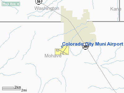
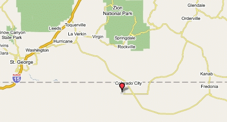
Colorado City Municipal Airport (ICAO: KAZC, FAA LID: AZC) is a general aviation airport located three miles (5 km) southwest of the central business district of Colorado City, in Mohave County, Arizona, United States. The airport is not served by any commercial airlines at this time. There are twelve aircraft based at the field.
Although most U.S. airports use the same three-letter location identifier for the FAA and IATA, Colorado City Municipal Airport is assigned AZC by the FAA but has no designation from the IATA.
Facilities
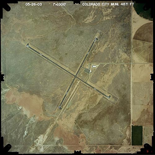
Colorado City Municipal Airport covers 209 acres (85 ha) and has two runways:
- Runway 11/29: 6,300 x 75 ft (1,920 x 23 m), Surface: Asphalt
- Runway 2/20: 5,099 x 60 ft (1,554 x 18 m), Surface: Asphalt
The above content comes from Wikipedia and is published under free licenses – click here to read more.
Colorado
City Municipal Airport is located along the Arizona-Utah border
in northwestern Arizona.
Location & QuickFacts
|
FAA
Information Effective: |
2005-10-27 |
|
Airport
Identifier: |
AZC |
|
Longitude/Latitude: |
113-00-50.0000W/36-57-35.8000N
-113.013889/36.959944 (Estimated) |
|
Elevation: |
4874 ft / 1485.60 m (Surveyed) |
|
Land: |
209 acres |
|
From
nearest city: |
3 nautical miles SW of Colorado City, AZ |
|
Location: |
Mohave County, AZ |
|
Magnetic
Variation: |
13E (1995) |
Ownership:
Publicly owned
Owner:
Town Of Colorado City
Address: P.o. Box70
Colorado City, ARIZONA 86021
Phone number: 520-875-2646
Manager: Ladell Bistline
Address: Box 726
Colorado City, AZ 86021
Phone number: 520-875-2871
AMGR HOME PHONE (520) 875-2308.
Airport Operations and Facilities
|
Airport Use: |
Open
to public |
|
Wind indicator: |
Yes |
|
Segmented Circle: |
Yes |
|
Control Tower: |
No |
|
Attendance Schedule: |
ALL/MON-SAT/0900-1800 |
|
Lighting Schedule: |
DUSK-DAWN
ACTVT MIRL RY 11/29; PAPI RYS 11 & 29 & REIL RYS 11 &
29 - CTAF. |
|
Beacon Color: |
Clear-Green (lighted land airport) |
|
Landing fee charge: |
No |
|
Sectional chart: |
Las
Vegas |
|
Region: |
AWP
- Western-Pacific |
|
Traffic Pattern
Alt: |
848
ft |
|
Boundary ARTCC: |
ZLA
- Los Angeles |
|
Tie-in FSS: |
PRC
- Prescott |
|
FSS on Airport: |
No |
|
FSS Phone: |
928-778-7810 |
|
FSS Toll Free: |
1-800-WX-BRIEF |
|
NOTAMs Facility: |
PRC (NOTAM-d service avaliable) |
|
Federal
Agreements: |
NGYS |
Airport Communications
|
CTAF: |
122.700 |
|
Unicom: |
122.700 |
Airport Services
|
Fuel available: |
100LLA |
|
Airframe Repair: |
MAJOR |
|
Power Plant Repair: |
MAJOR |
|
Bottled Oxygen: |
HIGH |
|
Bulk Oxygen: |
NONE |
Runway Information
Runway 02/20
|
Dimension: |
5099 x 60 ft / 1554.2 x 18.3 m |
|
Surface: |
ASPH, Good Condition |
|
Weight
Limit: |
Single wheel: 12500 lbs. |
|
Edge
Lights: |
Medium |
|
|
Runway 02 |
Runway 20 |
|
Longitude: |
113-01-00.6060W |
113-00-31.1350W |
|
Latitude: |
36-57-12.9830N |
36-57-57.4950N |
|
Elevation: |
4840.00 ft |
4874.00 ft |
|
Alignment: |
28 |
127 |
|
Traffic
Pattern: |
Left |
Left |
|
Markings: |
Basic, Poor Condition |
Basic, Poor Condition |
|
Runway
End Identifier: |
No |
No |
|
Centerline
Lights: |
No |
No |
|
Touchdown
Lights: |
No |
No |
|
Runway 11/29
|
Dimension: |
6300
x 75 ft / 1920.2 x 22.9 m |
|
Surface: |
ASPH,
Good Condition |
|
Weight Limit: |
Single
wheel: 30000 lbs. |
|
Edge Lights: |
Medium |
|
|
Runway 11 |
Runway 29 |
|
Longitude: |
113-01-25.9960W |
113-00-20.5880W |
|
Latitude: |
36-57-52.9330N |
36-57-19.4220N |
|
Elevation: |
4847.00 ft |
4854.00 ft |
|
Alignment: |
123 |
127 |
|
Traffic
Pattern: |
Right |
Left |
|
Markings: |
Basic, Poor Condition |
Basic, Poor Condition |
|
Crossing
Height: |
40.00 ft |
40.00 ft |
|
VASI: |
2-light PAPI on left side |
2-light PAPI on left side |
|
Visual
Glide Angle: |
3.00� |
3.00� |
|
Runway
End Identifier: |
Yes |
Yes |
|
Radio Navigation Aids
|
ID |
Type |
Name |
Ch |
Freq |
Var |
Dist |
|
AZC |
NDB |
Colorado City |
|
403.00 |
13E |
0.2 nm |
|
OZN |
VOR/DME |
St George |
035X |
109.80 |
15E |
28.8 nm |
|
CDC |
VOR/DME |
Cedar City |
120X |
117.30 |
16E |
49.8 nm |
Remarks
-
2000
FT MOUNTAINS N & NE OF ARPT.
-
3 FT
BRUSH WITHIN PRIMARY SFC OF RY 11/29.
Based Aircraft
|
Aircraft
based on field: |
12 |
|
Single
Engine Airplanes: |
11 |
|
Multi
Engine Airplanes: |
1 |
Operational Statistics
|
Aircraft
Operations: |
72/Week |
|
Air
Taxi: |
4.1% |
|
General
Aviation Local: |
47.3% |
|
General
Aviation Itinerant: |
47.3% |
|
Military: |
1.4% |
Address: Mohave County, AZ
Tel:
520-875-2871
Images and information placed above are from
http://www.airport-data.com/airport/AZC/
http://www.azdot.gov/aviation/airports/airports_list.asp?FAA=AZC
http://www.lat-long.com/Arizona/Colorado-City-Municipal-Airport_45336.html
We thank them for the data!
| General Info
|
| Country |
United States
|
| State |
ARIZONA
|
| FAA ID |
AZC
|
| Latitude |
36-57-35.800N
|
| Longitude |
113-00-50.000W
|
| Elevation |
4874 feet
|
| Near City |
COLORADO CITY
|
We don't guarantee the information is fresh and accurate. The data may be wrong or outdated.
For more up-to-date information please refer to other sources.
|
|


