Location & QuickFacts
|
FAA Information
Effective: |
2005-10-27 |
|
Airport Identifier: |
P33 |
|
Longitude/Latitude: |
109-53-40.6750W/32-14-43.4500N
-109.894632/32.245403 (Estimated) |
|
Elevation: |
4186
ft / 1275.89 m (Surveyed) |
|
Land: |
960
acres |
|
From nearest city: |
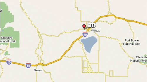
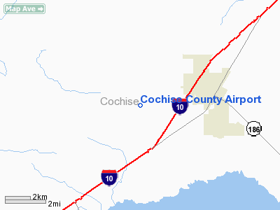
3 nautical miles W of Willcox, AZ |
|
Location: |
Cochise County, AZ |
|
Magnetic
Variation: |
11E (1995) |
Ownership:
Publicly owned
Owner:
Cochise County
Address: 1415 W Melody Lane
Bisbee, AZ 85603
Phone number: 520-432-5471
Manager:
Louise Walden
Address: Cochise County, Route 1 Box 607
Willcox, AZ 85643
Phone number: 520-384-2908
Airport Operations and Facilities
|
Airport Use: |
Open
to public |
|
Wind indicator: |
Yes |
|
Segmented Circle: |
Yes |
|
Control Tower: |
No |
|
Attendance Schedule: |
ALL/ALL/0800-1700, CLSD HOLS |
|
Lighting Schedule: |
DUSK-DAWN |
|
Beacon Color: |
Clear-Green (lighted land airport) |
|
Landing fee charge: |
No |
|
Sectional chart: |
Phoenix |
|
Region: |
AWP
- Western-Pacific |
|
Boundary ARTCC: |
ZAB
- Albuquerque |
|
Tie-in FSS: |
PRC
- Prescott |
|
FSS on Airport: |
No |
|
FSS Phone: |
928-778-7810 |
|
FSS Toll Free: |
1-800-WX-BRIEF |
|
NOTAMs Facility: |
PRC (NOTAM-d service avaliable) |
|
Federal
Agreements: |
NGY3 |
Airport Communications
|
CTAF: |
122.800 |
|
Unicom: |
122.800 |
Airport Services
|
Fuel available: |
100LLA |
|
Airframe Repair: |
MINOR |
|
Power Plant Repair: |
MINOR |
|
Bottled Oxygen: |
NONE |
|
Bulk Oxygen: |
NONE |
Runway Information
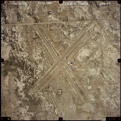
Runway 03/21
|
Dimension: |
6095
x 75 ft / 1857.8 x 22.9 m |
|
Surface: |
ASPH,
Good Condition |
|
Weight Limit: |
Single wheel: 50000 lbs.
Dual wheel: 75000 lbs.
Dual tandem wheel: 135000 lbs. |
|
Edge
Lights: |
Medium |
|
|
Runway 03 |
Runway 21 |
|
Longitude: |
109-54-05.8500W |
109-53-15.5000W |
|
Latitude: |
32-14-22.2000N |
32-15-04.7000N |
|
Elevation: |
4183.00 ft |
4186.00 ft |
|
Alignment: |
45 |
127 |
|
Traffic
Pattern: |
Left |
Left |
|
Markings: |
Basic, Fair Condition |
Basic, Fair Condition |
|
Runway
End Identifier: |
No |
No |
|
Centerline
Lights: |
No |
No |
|
Touchdown
Lights: |
No |
No |
|
Radio Navigation Aids
|
ID |
Type |
Name |
Ch |
Freq |
Var |
Dist |
|
DAO |
NDB |
Dragoo |
|
410.00 |
13E |
45.8 nm |
|
ARH |
TACAN |
Fort Huachuca |
053X |
|
12E |
45.7 nm |
|
FHU |
VOR |
Libby |
|
113.60 |
13E |
45.9 nm |
|
CIE |
VORTAC |
Cochise |
105X |
115.80 |
13E |
14.5 nm |
|
SSO |
VORTAC |
San Simon |
101X |
115.40 |
13E |
32.1 nm |
|
DUG |
VORTAC |
Douglas |
025X |
108.80 |
13E |
48.8 nm |
Remarks
-
TWY COND
POOR; NO HOLD LINES FOR RY 03 OR RY 21.
-
MILITARY TFC NEAR
AIRPORT
Address: Cochise County, AZ
Tel:
520-384-2908