|
 |
|
||||
|
Coordinates: 33°16′09″N 111°48′40″W / 33.26917°N 111.81111°W
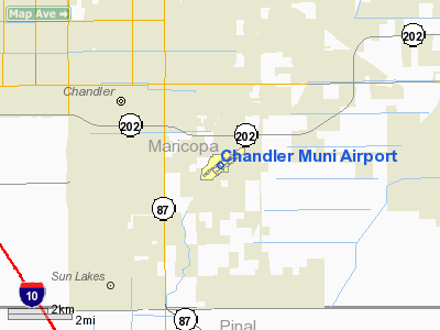
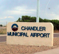
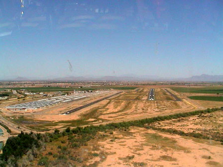
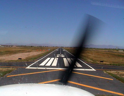
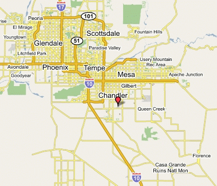
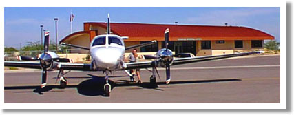
Chandler Municipal Airport (ICAO: KCHD, FAA LID: CHD) is a city-owned public-use airport located three miles (5 km) southeast of the central business district of Chandler, a city in Maricopa County, Arizona, United States. Although most U.S. airports use the same three-letter location identifier for the FAA and IATA, Chandler Municipal Airport is assigned CHD by the FAA but has no designation from the IATA (which assigned CHD to Phoenix-Mesa Gateway Airport in Mesa, Arizona - since redesignated by the IATA as AZA). As per Federal Aviation Administration records, the airport had 1,231 passenger boardings (enplanements) in calendar year 2005. According to the FAA's National Plan of Integrated Airport Systems for 2007–2011, Chandler Municipal is a general aviation airport and is also categorized as a reliever airport. FacilitiesChandler Municipal Airport covers 406 acres (164 ha) and has two asphalt paved runways: 4R/22L measuring 4,850 x 75 ft (1,478 x 23 m) and 4L/22R measuring 4,401 x 75 ft (1,341 x 23 m). It also has one helipad with a 100 x 100 ft (30 x 30 m) concrete surface. There is also a diner on site, named the Hangar Cafe. The above content comes from Wikipedia and is published under free licenses – click here to read more.
The Chandler Municipal Airport is located in one of the fastest growing cities in the United States. Only 20 miles southeast of downtown Phoenix, it is bordered on the north by Germann Road and to the south by Queen Creek Road. On the west side is McQueen Road and two miles to the east is Gilbert Road. Location & QuickFacts
Owner & Manager
Airport Operations and Facilities
Airport Communications
Airport Services
|
||||||||||||||||||||||||||||||||||||||||||||||||||||||||||||||||||||||||||||||||||||||||||||||||||||||||||||||||||||||||||||||||||||||||||||||||||||||||||||||||||||||||||||||||||||||||||||||||||||||||||||||||||||||||||||||||||||||||||||||||||||||||||||||||||||||||||||||||||||||||||||||||||||||||||||||||||||||||||||||||||||||||||||||||||||||||||||||||||||||||||||||
| Dimension: |
4401
x 75 ft / 1341.4 x 22.9 m |
|||||||||||||||||||||||||||||||||||||||
| Surface: |
ASPH, Good Condition |
|||||||||||||||||||||||||||||||||||||||
| Weight Limit: |
Single wheel: 30000 lbs. |
|||||||||||||||||||||||||||||||||||||||
| Edge Lights: |
Medium |
|||||||||||||||||||||||||||||||||||||||
|
||||||||||||||||||||||||||||||||||||||||
| Dimension: |
4850
x 75 ft / 1478.3 x 22.9 m |
||||||||||||||||||||||||||||||||||||
| Surface: |
ASPH, Good Condition |
||||||||||||||||||||||||||||||||||||
| Weight Limit: |
Single wheel: 30000 lbs. |
||||||||||||||||||||||||||||||||||||
| Edge Lights: |
Medium |
||||||||||||||||||||||||||||||||||||
|
|||||||||||||||||||||||||||||||||||||
| Dimension: |
100
x 100 ft / 30.5 x 30.5 m |
||||||
| Surface: |
CONC, |
||||||
|
|||||||
| ID |
Type |
Name |
Ch |
Freq |
Var |
Dist |
| CHD |
NDB |
Chandler |
407.00 |
12E |
0.2 nm |
|
| FFZ |
NDB |
Falcon Field |
281.00 |
12E |
12.2 nm |
|
| SDL |
NDB |
Scottsdale |
224.00 |
12E |
22.2 nm |
|
| LUF |
TACAN |
Luke |
077X |
13E |
32.8 nm |
|
| IWA |
VORTAC |
Willie |
080X |
113.30 |
13E |
8.3 nm |
| PXR |
VORTAC |
Phoenix |
103X |
115.60 |
12E |
12.7 nm |
| TFD |
VORTAC |
Stanfield |
095X |
114.80 |
12E |
23.6 nm |
| GBN |
VORTAC |
Gila Bend |
113X |
116.60 |
14E |
47.3 nm |
| PHX |
VOT |
Phoenix Sky Harbor |
109.00 |
14.0 nm |
Address: Maricopa County, AZ
Phone: (480) 782-3540
Fax: (480) 782-3541
E-mail: greg.chenoweth@chandleraz.gov
URL: http://www.chandler-airport.com/
Images and information placed above are from
http://www.chandler-airport.com/
http://www.airport-data.com/airport/CHD/
http://www.lat-long.com/Arizona/Chandler-Municipal-Airport_45331.html
We thank them for the data!
| General Info | |
|---|---|
| Country | United States |
| State | ARIZONA |
| FAA ID | CHD |
| Latitude | 33-16-08.700N |
| Longitude | 111-48-40.100W |
| Elevation | 1243 feet |
| Near City | CHANDLER |

 |
|
Copyright 2004-2026 © by Airports-Worldwide.com, Vyshenskoho st. 36, Lviv 79010, Ukraine Legal Disclaimer |