 |
|
|
|
|
|
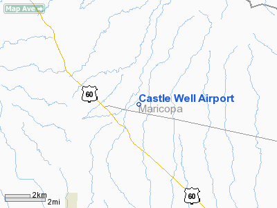
Location
& QuickFacts
| FAA Information Effective: |
2005-10-27 |
| Airport Identifier: |
0AZ5 |
| Longitude/Latitude: |
112-36-12.1260W/33-51-57.1170N
-112.603368/33.865866 (Estimated) |
| Elevation: |
2080
ft / 633.98 m (Estimated) |
| Land: |
0
acres |
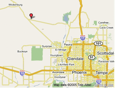
| From nearest city: |
1
nautical miles NE of Morristown, AZ |
| Location: |
Maricopa
County, AZ |
| Magnetic Variation: |
13E
(1980) |
Owner
& Manager
| Ownership: |
Privately
owned |
| Owner: |
Castle
Well Association |
| Address: |
41808
N 251-st Ave
Morristown, AZ 85342 |
| Phone number: |
623-388-9820 |
| Manager: |
Gerald
Dafoe |
| Address: |
41808
N 251-st Ave
Morristown, AZ 85342 |
| Phone number: |
623-388-9820 |
Airport
Operations and Facilities
| Airport Use: |
Private |
| Wind indicator: |
Yes |
| Segmented Circle: |
No |
| Control Tower: |
No |
| Attendance Schedule: |
IREG |
| Sectional chart: |
Phoenix |
| Region: |
AWP
- Western-Pacific |
| Boundary ARTCC: |
ZAB
- Albuquerque |
| Tie-in FSS: |
PRC
- Prescott |
| FSS on Airport: |
No |
| FSS Phone: |
928-778-7810 |
| FSS Toll Free: |
1-800-WX-BRIEF |
Runway
Information
Runway
17/35
| Dimension: |
1400
x 60 ft / 426.7 x 18.3 m |
| Surface: |
ASPH-DIRT,
CENTER 24 FT WIDE ASPH, WEST SHOULDER 20 FT DIRT, EAST SHOULDER
16 FT DIRT. |
| |
Runway
17 |
Runway
35 |
| Traffic Pattern: |
Left |
Right |
| Displaced threshold: |
675.00
ft |
563.00
ft |
| Obstruction: |
16
ft bldg, 750.0 ft from runway, 150 ft left of centerline,
48:1 slope to clear |
,
50:1 slope to clear |
|
Radio
Navigation Aids
| ID |
Type |
Name |
Ch |
Freq |
Var |
Dist |
| SDL |
NDB |
Scottsdale |
|
224.00 |
12E |
37.6
nm |
| FFZ |
NDB |
Falcon
Field |
|
281.00 |
12E |
49.9
nm |
| LUF |
TACAN |
Luke |
077X |
|
13E |
22.7
nm |
| BXK |
VORTAC |
Buckeye |
043X |
110.60 |
14E |
27.1
nm |
| PXR |
VORTAC |
Phoenix |
103X |
115.60 |
12E |
41.0
nm |
| PHX |
VOT |
Phoenix
Sky Harbor |
|
109.00 |
|
39.5
nm |
| PRC |
VOT |
Prescott |
|
110.00 |
|
48.1
nm |
Remarks
- ALL
ACFT TKOF RY 17, LEFT TURN AFTER TKOF.
- ALL
ACFT LAND ON RY 35.
- FENCE
LCTD 46 FT EAST AND FULL LENGTH RY 35.
- VFR
PRIVATE USE ONLY.
Address: Maricopa County, AZ
Tel:
623-388-9820
Images and information placed above are from
http://www.airport-data.com/airport/0AZ5/
http://www.lat-long.com/Arizona/Castle-Well-Airport_45420.html
We thank them for the data!
| General Info
|
| Country |
United States
|
| State |
ARIZONA
|
| FAA ID |
0AZ5
|
| Latitude |
33-51-57.117N
|
| Longitude |
112-36-12.126W
|
| Elevation |
2080 feet
|
| Near City |
MORRISTOWN
|
We don't guarantee the information is fresh and accurate. The data may be wrong or outdated.
For more up-to-date information please refer to other sources.
|
|


