Buckeye Municipal Airportin Arizona Arizona airports - Buckeye Municipal Airport
Buckeye Municipal Airportin Arizona - United States
Arizona Airports
USA Airports
World Airports
Airport photos - free!
Aircraft photos - free!
Spacecraft pics - free!
Aviation Articles

Buckeye Municipal Airport


Buckeye Municipal Airport
IATA: BXK – ICAO: KBXK – FAA LID: BXK
Summary
Airport type Public
Owner Town of Buckeye
Serves Buckeye, Arizona
Elevation AMSL 1,033 ft / 315 m
Coordinates 33°25′14″N 112°41′10″W / 33.42056°N 112.68611°W / 33.42056; -112.68611
Runways
Direction Length Surface
ft m
17/35 5,500 1,676 Asphalt
Statistics (2009)
Aircraft operations 52,920
Based aircraft 44
Source: Federal Aviation Administration

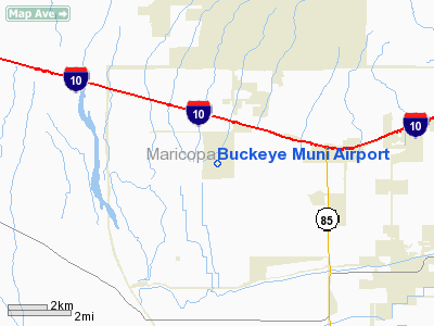
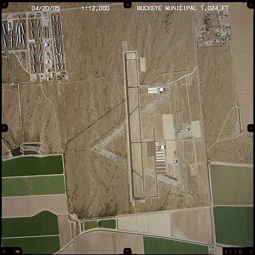
Buckeye Municipal Airport (IATA: BXK, ICAO: KBXK, FAA LID: BXK) is a town-owned public-use airport located six nautical miles (11 km) northwest of the central business district of Buckeye, a town in Maricopa County, Arizona, United States. The airport is included in the FAA's National Plan of Integrated Airport Systems for 2009–2013, which categorizes it as a general aviation facility. It is not served by any commercial airlines at this time.

Facilities and aircraft

Buckeye Municipal Airport covers an area of 706 acres (286 ha) at an elevation of 1,033 feet (315 m) above mean sea level. It has one runway designated 17/35 with an asphalt surface measuring 5,500 by 75 feet (1,676 x 23 m).

For the 12-month period ending April 22, 2009, the airport had 52,920 aircraft operations, an average of 144 per day: 99.8% general aviation, 0.2% military and <0.1% air taxi. At that time there were 44 aircraft based at this airport: 75% single-engine, 5% multi-engine, 9% helicopter and 11% ultralight.


The above content comes from Wikipedia and is published under free licenses – click here to read more.


Buckeye Municipal Airport

The Town of Buckeye is home to the Buckeye Municipal Airport. The airport is located approximately 1 mile south of Interstate-10 at the Palo Verde interchange. Currently, our Airport is equipped with a 5,500 ft. north/south aligned runway designed for use by small, general aviation aircraft. The figure below illustrates the current layout of the Buckeye Municipal Airport.

Buckeye Municipal Airport serves Buckeye and Maricopa County and is owned by Town Of Buckeye. The paved runway extends for 4300 feet. The facility is at an elevation of 1021 feet at a distance of about 6 miles from Buckeye.

Although the Buckeye Municipal Airport is currently used for small, general aviation aircraft, its size (800 acres) and location (1/4 mile from a major interchange off of Interstate 10) give it the potential to be an exceptional commercial airpark. It is already the home of the Groen Brothers Aviation Company flight testing operation, which has created approximately 45 high-tech aviation jobs at the airport. In the "Sites Available" section of this web site, there is a detailed plan featuring available commercial and industrial areas at the Buckeye Municipal Airport.

Buckeye Municipal Airport

Location & QuickFacts

FAA Information Effective:

2005-10-27

Airport Identifier:

BXK

Longitude/Latitude:

112-41-10.2510W/33-25-13.5000N
-112.686181/33.420417 (Estimated)

Elevation:

1021 ft / 311.20 m (Surveyed)

Land:

706 acres

From nearest city:

6 nautical miles NW of Buckeye, AZ

Location:

Maricopa County, AZ

Magnetic Variation:

13E (1985)

Owner & Manager

Ownership:

Publicly owned

Owner:

Town Of Buckeye

Address:

100 North Apache
Buckeye, AZ 85326

Phone number:

623-386-4691

Manager:

Jason Hardison

Address:

508 East Monroe Ave
Buckeye, AZ 85326

Phone number:

623-386-9482
CELL PHONE: 602-680-8320

Airport Operations and Facilities

Airport Use:

Open to public

Wind indicator:

Yes

Segmented Circle:

No

Control Tower:

No

Attendance Schedule:

ALL/MON-FRI/0800-1700

Lighting Schedule:

DUSK-DAWN
ACTVT MIRL RY 17/35 - CTAF.

Beacon Color:

Clear-Green (lighted land airport)

Landing fee charge:

No

Sectional chart:

Phoenix

Region:

AWP - Western-Pacific

Traffic Pattern Alt:

976 ft

Boundary ARTCC:

ZAB - Albuquerque

Tie-in FSS:

PRC - Prescott

FSS on Airport:

No

FSS Phone:

928-778-7810

FSS Toll Free:

1-800-WX-BRIEF

NOTAMs Facility:

PRC (NOTAM-d service avaliable)

Federal Agreements:

NGPY

Airport Communications

CTAF:

122.800

Unicom:

122.800 

Airport Services

Fuel available:

100LLA
100LL 24HRS SELF SERVICE JET A AVAIL M-F 0700-1700 OR CALL 602 386 2428.

Airframe Repair:

MAJOR

Power Plant Repair:

MAJOR

Bottled Oxygen:

NONE

Bulk Oxygen:

NONE

Runway Information

Runway 17/35

Dimension:

5500 x 75 ft / 1676.4 x 22.9 m

Surface:

ASPH, Good Condition

Weight Limit:

Single wheel: 12500 lbs.

Edge Lights:

Medium


Runway 17

Runway 35

Longitude:

112-41-09.1010W

112-41-11.4000W

Latitude:

33-25-48.3240N

33-24-53.9450N

Elevation:

1033.00 ft

995.00 ft

Alignment:

127

2

Traffic Pattern:

Right

Left

Markings:

Basic, Good Condition

Basic, Good Condition

Crossing Height:

40.00 ft

0.00 ft

VASI:

2-light PAPI on left side

4-light PAPI on left side

Visual Glide Angle:

3.00°

0.00°

Runway End Identifier:


Yes

Radio Navigation Aids

ID

Type

Name

Ch

Freq

Var

Dist

SDL

NDB

Scottsdale


224.00

12E

41.0 nm

CHD

NDB

Chandler


407.00

12E

45.1 nm

FFZ

NDB

Falcon Field


281.00

12E

47.9 nm

LUF

TACAN

Luke

077X


13E

16.9 nm

BXK

VORTAC

Buckeye

043X

110.60

14E

7.2 nm

GBN

VORTAC

Gila Bend

113X

116.60

14E

27.9 nm

PXR

VORTAC

Phoenix

103X

115.60

12E

35.9 nm

PHX

VOT

Phoenix Sky Harbor


109.00


34.0 nm

Remarks

  • PARACHUTE JUMPING ON FLD.


Address: Maricopa County, AZ

Tel: 623-386-9482


Images and information placed above are from
http://www.airport-data.com/airport/BXK/
http://www.buckeyedevelopment.com/html/locations/airtrans.html
http://www.azdot.gov/aviation/airports/airports_list.asp?FAA=BXK
We thank them for the data!


General Info
Country United States
State ARIZONA
FAA ID BXK
Latitude 33-25-15.188N
Longitude 112-41-10.680W
Elevation 1021 feet
Near City BUCKEYE


We don't guarantee the information is fresh and accurate. The data may be wrong or outdated.
For more up-to-date information please refer to other sources.


christianity portal
directory of hotels worldwide


Copyright 2004-2024 © by Airports-Worldwide.com, Vyshenskoho st. 36, Lviv 79010, Ukraine
Legal Disclaimer