 |
|
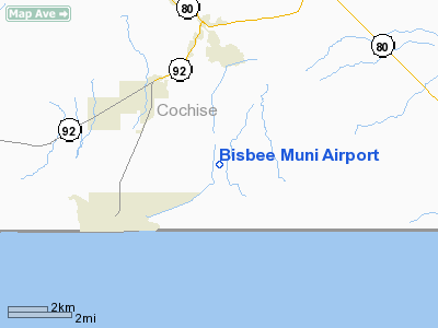
| Bisbee Municipal Airport |
| IATA: BSQ – ICAO: none – FAA LID: P04 |
| Summary |
| Airport type |
Public |
| Owner |
City of Bisbee |
| Serves |
Bisbee, Arizona |
| Elevation AMSL |
4,780 ft / 1,457 m |
| Coordinates |
31°21′50″N 109°52′59″W / 31.36389°N 109.88306°W / 31.36389; -109.88306 |
| Runways |
| Direction |
Length |
Surface |
| ft |
m |
| 17/35 |
5,929 |
1,807 |
Asphalt |
| 2/20 |
2,650 |
808 |
Dirt |
| Statistics (2008) |
| Aircraft operations |
4,900 |
| Based aircraft |
15 |
| Source: Federal Aviation Administration |
Bisbee Municipal Airport (IATA: BSQ, FAA LID: P04) is a city-owned public-use airport located five nautical miles (9 km) southeast of the central business district of Bisbee, a city in Cochise County, Arizona, United States.
Facilities and aircraft
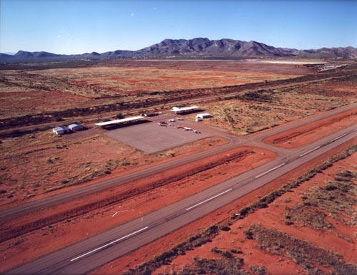
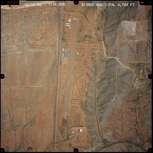
Bisbee Municipal Airport covers an area of 300 acres (121 ha) at an elevation of 4,780 feet (1,457 m) above mean sea level. It has two runways: 17/35 is 5,929 by 60 feet (1,807 x 18 m) with an asphalt pavement; 2/20 is 2,650 by 110 feet (808 x 34 m) with a dirt surface.
For the 12-month period ending April 16, 2008, the airport had 4,900 aircraft operations, an average of 13 per day, all of which were general aviation. At that time there were 15 aircraft based at this airport: 87% single-engine and 13% ultralight.
The above content comes from Wikipedia and is published under free licenses – click here to read more.
The
role of the Bisbee Municipal Airport is service to the
southeastern Arizona general aviation community, which includes business
travel, charter, sport aviation, and training as well as private use of
light aircraft. With continued scheduled maintenance and improvements,
the airport will be able to continue to fulfill its role within its service
area and the county’s airport system.
 Bisbee
Municipal Airport Facts Bisbee
Municipal Airport Facts
The airport is located 3 miles south of the Bisbee suburb of Warren
and 2 miles north of the Mexican border and customs crossing at Naco,
Arizona.
Runway 17/35 5900ft x 60ft, Paved, Pilot controlled lighting and Precision
Approach Path Indicator (PAPI).
Runway 02/200 2900 x 200ft, Packed earth, but soon to be paved, lighted
and lengthened 24 hour Fixed Based Operator (Copper State Aircraft Services)
with fuel, courtesy car, and security at (520) 432-6030.
Large ramp area with 31 Tie downs, 10 Shade Hangers, and 3 Hangers.
Bisbee Airpark, at north end of airport has commercial hangers for rent/lease.
Bisbee Airport has approximately 19 acres available for commercial
development. The airport has a current and approved master development
plan from the City of Bisbee and the Arizona Dept. of Transportation.
Since May 2001, we have had 23,623 flight operations at P04 (Bisbee
Municipal Airport) and 642 pilots/passengers have stayed over at least
one night in Bisbee.
Anecdotal information suggests that the average spent during an overnight
stay is $220.00 ( We ask pilots how much they spent during stay) There
are 23 aircraft stationed at P04, only Sierra Vista has more aircraft,
in Cochise County.
Location
& QuickFacts
| FAA Information Effective: |
2005-10-27 |
| Airport Identifier: |
P04 |
| Longitude/Latitude: |
109-52-59.2630W/31-21-50.3650N
-109.883129/31.363990 (Estimated) |
| Elevation: |
4780
ft / 1456.94 m (Estimated) |
| Land: |
300
acres |
| From nearest city: |
5
nautical miles SE of Bisbee, AZ |
| Location: |
Cochise
County, AZ |
| Magnetic Variation: |
12E
(1985) |
Owner
& Manager
| Ownership: |
Publicly
owned |
| Owner: |
City
Of Bisbee |
| Address: |
118
Arizona St
Bisbee, AZ 85603 |
| Phone number: |
520-432-5446 |
| Manager: |
Richard
Soto
FAX 520-432-6069, EMAIL: COBAIR@THERIVER.COM |
| Address: |
City
Of Bisbee, 118 Arizona St
Bisbee, AZ 85603 |
| Phone number: |
520-432-6030 |
Airport
Operations and Facilities
| Airport Use: |
Open
to public |
| Wind indicator: |
Yes |
| Segmented Circle: |
Yes |
| Control Tower: |
No |
| Attendance Schedule: |
ALL/ALL/ALL |
| Lighting Schedule: |
DUSK-DAWN
PCL; KEY 122.8 3 TIMES. INTST LEVEL PRESET. |
| Beacon Color: |
Clear-Green
(lighted land airport) |
| Landing fee charge: |
No |
| Sectional chart: |
Phoenix |
| Region: |
AWP
- Western-Pacific |
| Traffic Pattern Alt: |
1000
ft |
| Boundary ARTCC: |
ZAB
- Albuquerque |
| Tie-in FSS: |
PRC
- Prescott |
| FSS on Airport: |
No |
| FSS Phone: |
928-778-7810 |
| FSS Toll Free: |
1-800-WX-BRIEF |
| NOTAMs Facility: |
PRC
(NOTAM-d service avaliable) |
| Federal Agreements: |
NGY |
Airport
Communications
| CTAF: |
122.800 |
| Unicom: |
122.800
|
Airport
Services
| Fuel available: |
100LL |
| Airframe Repair: |
MAJOR |
| Power Plant Repair: |
MAJOR |
| Bottled Oxygen: |
NONE |
| Bulk Oxygen: |
NONE |
Runway
Information
Runway
02/20
| Dimension: |
2650
x 110 ft / 807.7 x 33.5 m |
| Surface: |
DIRT,
Fair Condition |
| |
Runway
02 |
Runway
20 |
| Traffic Pattern: |
Left |
Left |
| Markings: |
None,
|
None,
|
| Runway End Identifier: |
No |
No |
| Centerline Lights: |
No |
No |
| Touchdown Lights: |
No |
No |
| Obstruction: |
,
50:1 slope to clear |
9
ft bush, 0.0 ft from runway, 2:1 slope to clear |
|
Runway
17/35
| Dimension: |
5929
x 60 ft / 1807.2 x 18.3 m |
| Surface: |
ASPH,
Good Condition |
| Weight Limit: |
Single
wheel: 12000 lbs. |
| Edge Lights: |
Medium |
| |
Runway
17 |
Runway
35 |
| Traffic Pattern: |
Left |
Left |
| Markings: |
Basic,
Good Condition |
Basic,
Good Condition |
| VASI: |
2-light
PAPI on left side |
2-light
PAPI on left side |
| Runway End Identifier: |
No |
No |
| Centerline Lights: |
No |
No |
| Touchdown Lights: |
No |
No |
| Obstruction: |
9
ft bush, 217.0 ft from runway, 113 ft left of centerline,
1:1 slope to clear
5 FT BUSH 112 FT FM EOR 90 FT LEFT. |
15
ft bush, 255.0 ft from runway, 70 ft right of centerline,
3:1 slope to clear
SCATTERED BRUSH UP TO 9 FT 70 FT FM EOR. |
|
Radio
Navigation Aids
| ID |
Type |
Name |
Ch |
Freq |
Var |
Dist |
| DAO |
NDB |
Dragoo |
|
410.00 |
13E |
27.1
nm |
| ENZ |
NDB |
Nogales |
|
394.00 |
12E |
49.5
nm |
| ARH |
TACAN |
Fort
Huachuca |
053X |
|
12E |
26.9
nm |
| FHU |
VOR |
Libby |
|
113.60 |
13E |
27.7
nm |
| OLS |
VOR/DME |
Nogales |
019X |
108.20 |
12E |
49.6
nm |
| DUG |
VORTAC |
Douglas |
025X |
108.80 |
13E |
15.8
nm |
| CIE |
VORTAC |
Cochise |
105X |
115.80 |
13E |
40.7
nm |
Remarks
- 2'
SCATTERED BRUSH WITHIN PRIMARY SFC OF RY 17/35; 10' SCATTERED BRUSH
WITHIN PRIMARY SFC OF RY 02/20.
Address: Cochise County, AZ
Tel:
520-432-6030
URL: http://www.presho-it.com/index.htm
Images and information placed above are from
http://www.presho-it.com/index.htm
http://www.airport-data.com/airport/P04/
http://www.discoverbisbee.com/about_air.htm
http://www.azdot.gov/aviation/airports/airports_list.asp?FAA=P04
We thank them for the data!
| General Info
|
| Country |
United States
|
| State |
ARIZONA
|
| FAA ID |
P04
|
| Latitude |
31-21-50.365N
|
| Longitude |
109-52-59.263W
|
| Elevation |
4780 feet
|
| Near City |
BISBEE
|
We don't guarantee the information is fresh and accurate. The data may be wrong or outdated.
For more up-to-date information please refer to other sources.
|
|


