 |
|
Bisbee Douglas International Airport |
| Bisbee Douglas International Airport |
| IATA: DUG – ICAO: KDUG – FAA LID: DUG |
| Summary |
| Airport type |
Public |
| Owner |
Cochise County |
| Serves |
Douglas & Bisbee, Arizona |
| Elevation AMSL |
4,154 ft / 1,266 m |
| Coordinates |
31°28′08″N 109°36′13″W / 31.46889°N 109.60361°W / 31.46889; -109.60361 |
| Runways |
| Direction |
Length |
Surface |
| ft |
m |
| 17/35 |
7,311 |
2,228 |
Asphalt |
| 8/26 |
5,000 |
1,524 |
Asphalt |
| Statistics (2009) |
| Aircraft operations |
19,650 |
| Based aircraft |
19 |
| Source: Federal Aviation Administration |
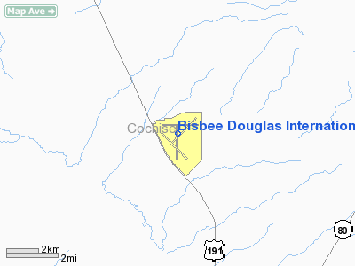
Bisbee Douglas International Airport (IATA: DUG, ICAO: KDUG, FAA LID: DUG) is a county-owned public-use airport located eight nautical miles (15 km) northwest of the central business district of Douglas and 15 nautical miles (28 km) east of Bisbee, both cities in Cochise County, Arizona, United States. The airport is included in the FAA's National Plan of Integrated Airport Systems for 2009–2013, which categorizes it as a general aviation facility. History
The airport was constructed between 1941 and 1943 and was used as a bomber training airfield during World War II. In 1949 the US Government gave the airport to Cochise County for use as a regional air transportation center.
The airport is not served by any commercial airlines at this time, although in the 1960s the airport was served by commercial air service.
Facilities and aircraft
Bisbee Douglas International Airport covers an area of 3,000 acres (1,214 ha) at an elevation of 4,154 feet (1,266 m) above mean sea level. It has two asphalt paved runways: 17/35 is 7,311 by 100 feet (2,228 x 30 m) and 8/26 is 5,000 by 75 feet (1,524 x 23 m).
For the 12-month period ending March 31, 2009, the airport had 19,650 aircraft operations, an average of 53 per day: 71% general aviation and 29% military. At that time there were 19 aircraft based at this airport: 95% single-engine and 5% multi-engine.
The above content comes from Wikipedia and is published under free licenses – click here to read more.
Location
& QuickFacts
| FAA Information Effective: |
2005-10-27 |
| Airport Identifier: |
DUG |
| Longitude/Latitude: |
109-36-13.2000W/31-28-08.5000N
-109.603667/31.469028 (Estimated) |
| Elevation: |
4154
ft / 1266.14 m (Surveyed) |
| Land: |
3000
acres |
| From nearest city: |
8
nautical miles NW of Douglas Bisbee, AZ |
| Location: |
Cochise
County, AZ |
| Magnetic Variation: |
12E
(1985) |
Owner
& Manager
| Ownership: |
Publicly
owned |
| Owner: |
Cochise
County |
| Address: |
1415
West Melody Lane
Bisbee, AZ 85603 |
| Phone number: |
520-432-9730 |
| Manager: |
L.
H. Hamilton |
| Address: |
1415
Melody Lane, Bldg C
Bisbee, AZ 85603 |
| Phone number: |
520-432-9734
ALTERNATE NUMBER (520) 364-2852 |
Airport
Operations and Facilities
| Airport Use: |
Open
to public |
| Wind indicator: |
Yes |
| Segmented Circle: |
Yes |
| Control Tower: |
No |
| Attendance Schedule: |
ALL/MON-FRI/0730-1630 |
| Lighting Schedule: |
DUSK-DAWN
ACTVT MIRL RY 17/35 VASI RY 17 - CTAF. |
| Beacon Color: |
Clear-Green
(lighted land airport) |
| Landing fee charge: |
No |
| Sectional chart: |
Phoenix |
| Region: |
AWP
- Western-Pacific |
| Boundary ARTCC: |
ZAB
- Albuquerque |
| Tie-in FSS: |
PRC
- Prescott |
| FSS on Airport: |
No |
| FSS Phone: |
928-778-7810 |
| FSS Toll Free: |
1-800-WX-BRIEF |
| NOTAMs Facility: |
DUG
(NOTAM-d service avaliable) |
| Federal Agreements: |
NGPY3 |
Airport
Communications
| CTAF: |
123.000 |
| Unicom: |
123.000
|
Airport
Services
| Fuel available: |
100LLA
FUEL SVC FEE 2000-0730 M-F ALL DAY SAT-SUN; PHONE (520)364-2771. |
| Airframe Repair: |
MAJOR |
| Power Plant Repair: |
MAJOR |
| Bottled Oxygen: |
NONE |
| Bulk Oxygen: |
NONE |
Runway
Information
Runway
08/26
| Dimension: |
5000
x 75 ft / 1524.0 x 22.9 m |
| Surface: |
ASPH,
Good Condition |
| Weight Limit: |
Single
wheel: 12500 lbs. |
| Edge Lights: |
Medium
MIRL RY 08/26 OTS INDEFLY. |
| |
Runway
08 |
Runway
26 |
| Longitude: |
109-36-39.0700W |
109-35-41.3400W |
| Latitude: |
31-28-26.6500N |
31-28-26.4900N |
| Elevation: |
4113.00
ft |
4145.00
ft |
| Alignment: |
90 |
127 |
| Traffic Pattern: |
Left |
Left |
| Markings: |
Basic,
Fair Condition |
Basic,
Fair Condition |
|
Runway
17/35
| Dimension: |
7311
x 100 ft / 2228.4 x 30.5 m |
| Surface: |
ASPH,
Good Condition |
| Surface Treatment: |
Rubberized
Friction Seal Coat
RFSC 100 FT WIDE. |
| Weight Limit: |
Single
wheel: 30000 lbs.
Dual wheel: 160000 lbs.
Dual tandem wheel: 250000 lbs. |
| Edge Lights: |
Medium
MIRL RY 08/26 OTS INDEFLY. |
| |
Runway
17 |
Runway
35 |
| Longitude: |
109-36-16.1770W |
109-36-15.8800W |
| Latitude: |
31-28-27.3320N |
31-27-14.9980N |
| Elevation: |
4126.00
ft |
4082.00
ft |
| Alignment: |
127 |
127 |
| Traffic Pattern: |
Left |
Left |
| Markings: |
Non-precision
instrument, Good Condition |
Non-precision
instrument, Fair Condition |
| Crossing Height: |
0.00
ft |
49.00
ft |
| VASI: |
2-box
on left side
VASI RY 17 OTS INDEFLY. |
2-box
on left side |
| Visual Glide Angle: |
0.00� |
3.00� |
| Runway End Identifier: |
No |
No |
| Centerline Lights: |
No |
No |
| Touchdown Lights: |
No |
No |
|
Radio
Navigation Aids
| ID |
Type |
Name |
Ch |
Freq |
Var |
Dist |
| DAO |
NDB |
Dragoo |
|
410.00 |
13E |
38.6
nm |
| ARH |
TACAN |
Fort
Huachuca |
053X |
|
12E |
38.3
nm |
| FHU |
VOR |
Libby |
|
113.60 |
13E |
39.2
nm |
| DUG |
VORTAC |
Douglas |
025X |
108.80 |
13E |
0.2
nm |
| CIE |
VORTAC |
Cochise |
105X |
115.80 |
13E |
34.8
nm |
Address: Cochise County, AZ
Tel:
520-432-9734
Images and information placed above are from
http://www.airport-data.com/airport/DUG/
We thank them for the data!
| General Info
|
| Country |
United States
|
| State |
ARIZONA
|
| FAA ID |
DUG
|
| Latitude |
31-28-08.500N
|
| Longitude |
109-36-13.200W
|
| Elevation |
4154 feet
|
| Near City |
DOUGLAS BISBEE
|
We don't guarantee the information is fresh and accurate. The data may be wrong or outdated.
For more up-to-date information please refer to other sources.
|
|


