|
 |
|
||||
|
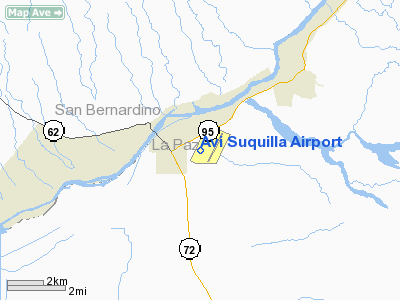
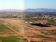
Avi Suquilla Airport (FAA LID: P20) is a public use airport located one nautical mile (1.8 km) east of the central business district of Parker, a town in La Paz County, Arizona, United States. It is owned by the Colorado River Indian Tribes. The airport is located near the Colorado River and serves many people who come into the area to make use of the river. Facilities and aircraftAvi Suquilla Airport covers an area of 240 acres (97 ha) at an elevation of 452 feet (138 m) above mean sea level. It has one asphalt paved runway designated 1/19 which measures 4,780 by 75 feet (1,457 x 23 m). For the 12-month period ending May 1, 2007, the airport had 10,200 aircraft operations, an average of 27 per day, all general aviation. At that time there were 29 aircraft based at this airport: 69% single-engine, 24% multi-engine and 7% helicopter. CRIT AIR is the fixed base operator (FBO) on the field that takes care of fuel, unicom, parking, and other necessities. On the field, there are T hangers available for rent but go quickly. Also there is gated parking available for the use of pilots. The airport has 100LL and Jet A available on field seven days a week, from 8am-5pm. Fueling is available on call after hours for an additional fee. To see current fuel prices, see the FUEL section below, this section will be updated according to current prices. Larger corporate jets can request catering that is provided by the Blue Water Resort and Casino. Within the Blue Water Resort and Casino there is gambling, restaurants, movie theaters, miniature golf, indoor water park, and an arcade for the kids. The CRIT AIR staff is always happy to provide courtesy shuttle to and from destinations within the area, be advised only 4 people at a time can be taken via the courtesy shuttle. ActivityThe airport does not have large carrier service at this time, but it does have a majority of General Aviation aircraft on the field as well as two medical flight companies. Tri-State Careflight is the company that makes many of the medical flights in and out of Phoenix and Las Vegas to Parker, they are flying the Beechcraft C90 King Air based on the field. TSCF also has helicopters that operate in and out of P20 and also do the same type of flights that the fixed wing operations do. The TSCF helicopters most of the time are 'lifting' from the La Paz Regional Hospital one mile west of the field. Omniflight, the parent company of Native Air has recently began operations regularly from P20 as well as the Parker Indian Hospital. As of now, there is no fixed wing operations operated by Native Air, but helicopter operation is spontaneous. Currently, there is no activity that is a hindrance or a concern to pilots such as parachuting or glider activity. ExpansionAn expansion project was recently completed, including a new runway measuring 6,250 feet (1,910 m) long by 100 feet (30 m) wide that can accommodate many different aircraft. In the new runway, there is one taxiway to exit approximately mid-field at A2. The old runway has been decommissioned and will later be overlaid and be another taxiway. More construction is continually going on that will make flying in easier and more enjoyable. There are future plans to update th fueling office and administration/pilots' lounge. The above content comes from Wikipedia and is published under free licenses – click here to read more.
Location & QuickFacts
Owner & Manager
Airport Operations and Facilities
Airport Communications
Airport Services
Runway Information Runway 01/19
Radio Navigation Aids
Remarks
Address: La Paz County, AZ Phone: 928-669-2168
Images and information placed above are from
We don't guarantee the information is fresh and accurate. The data may be wrong or outdated. For more up-to-date information please refer to other sources. |
||||||||||||||||||||||||||||||||||||||||||||||||||||||||||||||||||||||||||||||||||||||||||||||||||||||||||||||||||||||||||||||||||||||||||||||||||||||||||||||||||||||||||||||||||||||||||||||||||||||||||||||||||||||||||||||||||||||||||||||||||||||||||||||||||||||||||

 |
|
Copyright 2004-2026 © by Airports-Worldwide.com, Vyshenskoho st. 36, Lviv 79010, Ukraine Legal Disclaimer |