 |
|
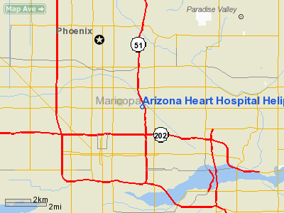
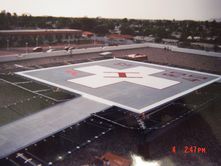
Arizona Heart Hospital Heliport |
|
|
Location
& QuickFacts
| FAA Information Effective: |
2005-10-27 |
| Airport Identifier: |
0AZ0 |
| Longitude/Latitude: |
112-02-24.5000W/33-28-52.5000N
-112.040139/33.481250 (Estimated) |
| Elevation: |
1161
ft / 353.87 m (Estimated) |
| Land: |
0
acres |
| From nearest city: |
3
nautical miles N of Phoenix, AZ |
| Location: |
Maricopa
County, AZ |
| Magnetic Variation: |
12E
(1995) |
Owner
& Manager
| Ownership: |
Privately
owned |
| Owner: |
Arizona
Heart Hospital |
| Address: |
1930
East Thomas Rd
Phoenix, AZ 85016 |
| Phone number: |
602-532-1000 |
| Manager: |
David
Leckie |
| Address: |
Arizona
Heart Hospital, 1930 East Thomas Rd
Phoenix, AZ 85016 |
| Phone number: |
602-532-1000 |
Airport
Operations and Facilities
| Airport Use: |
Private |
| Wind indicator: |
Yes |
| Segmented Circle: |
No |
| Control Tower: |
No |
| Attendance Schedule: |
ALL/ALL/ALL |
| Lighting Schedule: |
DUSK-DAWN
FOR FLOOD LGTS CALL (602) 532-1000 OR 5 CLICKS ON FREQ 123.05. |
| Beacon Color: |
Clear-Green-Yellow
(heliport) |
| Sectional chart: |
Phoenix |
| Region: |
AWP
- Western-Pacific |
| Boundary ARTCC: |
ZAB
- Albuquerque |
| Tie-in FSS: |
PRC
- Prescott |
| FSS Phone: |
928-778-7810 |
| FSS Toll Free: |
1-800-WX-BRIEF |
Runway
Information
Helipad H1
| Dimension: |
40
x 40 ft / 12.2 x 12.2 m |
| Surface: |
MATS,
|
| |
Runway
H1 |
Runway
|
| Traffic Pattern: |
Left |
Left |
|
Radio
Navigation Aids
| ID |
Type |
Name |
Ch |
Freq |
Var |
Dist |
| SDL |
NDB |
Scottsdale |
|
224.00 |
12E |
11.1
nm |
| FFZ |
NDB |
Falcon
Field |
|
281.00 |
12E |
15.4
nm |
| CHD |
NDB |
Chandler |
|
407.00 |
12E |
17.4
nm |
| LUF |
TACAN |
Luke |
077X |
|
13E |
17.4
nm |
| PXR |
VORTAC |
Phoenix |
103X |
115.60 |
12E |
4.6
nm |
| IWA |
VORTAC |
Willie |
080X |
113.30 |
13E |
22.3
nm |
| TFD |
VORTAC |
Stanfield |
095X |
114.80 |
12E |
36.4
nm |
| BXK |
VORTAC |
Buckeye |
043X |
110.60 |
14E |
39.4
nm |
| GBN |
VORTAC |
Gila
Bend |
113X |
116.60 |
14E |
44.9
nm |
| PHX |
VOT |
Phoenix
Sky Harbor |
|
109.00 |
|
3.2
nm |
Remarks
- PROVIDED
VFR, PRIVATE USE, OBSTRUCTION FREE INGRESS AND EGRESS.
Address: Maricopa County, AZ
Phone: 602-532-1000
Images and information placed above are from
http://www.airport-data.com/airport/0AZ0/
http://www.federalequipment.com/arizona1.html
We thank them for the data!
| General Info
|
| Country |
United States
|
| State |
ARIZONA
|
| FAA ID |
0AZ0
|
| Latitude |
33-28-54.000N
|
| Longitude |
112-02-27.000W
|
| Elevation |
1126 feet
|
| Near City |
PHOENIX
|
We don't guarantee the information is fresh and accurate. The data may be wrong or outdated.
For more up-to-date information please refer to other sources.
|
|


