 |
|
|
|
|
|
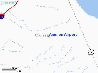
Location
& QuickFacts
| FAA Information Effective: |
2005-10-27 |
| Airport Identifier: |
AZ14 |
| Longitude/Latitude: |
109-57-27.0000W/32-01-29.0000N
-109.957500/32.024722 (Estimated) |
| Elevation: |
4510
ft / 1374.65 m (Estimated) |
| Land: |
160
acres |
| From nearest city: |
20
nautical miles NW of Willcox, AZ |
| Location: |
Cochise
County, AZ |
| Magnetic Variation: |
12E
(1990) |
Owner
& Manager
| Ownership: |
Privately
owned |
| Owner: |
Peter
J. Ammon |
| Address: |
Box
176
Dragoon, AZ 85609 |
| Phone number: |
602-826-3522 |
| Manager: |
Peter
J. Ammon |
| Address: |
Box
176
Dragoon, AZ 85609 |
| Phone number: |
602-826-3522 |
Airport
Operations and Facilities
| Airport Use: |
Private |
| Wind indicator: |
Yes |
| Segmented Circle: |
No |
| Control Tower: |
No |
| Attendance Schedule: |
ALL/ALL/ALL |
| Sectional chart: |
Albuquerque |
| Region: |
AWP
- Western-Pacific |
| Boundary ARTCC: |
ZAB
- Albuquerque |
| Tie-in FSS: |
PRC
- Prescott |
| FSS on Airport: |
No |
| FSS Phone: |
928-778-7810 |
| FSS Toll Free: |
1-800-WX-BRIEF |
Runway
Information Runway
09/27
| Dimension: |
2050
x 75 ft / 624.8 x 22.9 m |
| Surface: |
DIRT,
|
| |
Runway
09 |
Runway
27 |
| Traffic Pattern: |
Left |
Left |
|
Radio
Navigation Aids
| ID |
Type |
Name |
Ch |
Freq |
Var |
Dist |
| DAO |
NDB |
Dragoo |
|
410.00 |
13E |
33.0
nm |
| ARH |
TACAN |
Fort
Huachuca |
053X |
|
12E |
32.8
nm |
| DMA |
TACAN |
Davis
Monthan |
123X |
|
12E |
47.7
nm |
| FHU |
VOR |
Libby |
|
113.60 |
13E |
33.1
nm |
| CIE |
VORTAC |
Cochise |
105X |
115.80 |
13E |
10.2
nm |
| DUG |
VORTAC |
Douglas |
025X |
108.80 |
13E |
37.8
nm |
| SSO |
VORTAC |
San
Simon |
101X |
115.40 |
13E |
38.3
nm |
| TUS |
VORTAC |
Tucson |
107X |
116.00 |
12E |
49.0
nm |
Remarks
- LAND
ONLY RWY 27.
- PROVIDED
VFR PVT USE.
Address: Cochise County, AZ
Phone: 602-826-3522
Images and information placed above are from
http://www.airport-data.com/airport/AZ14/
We thank them for the data!
| General Info
|
| Country |
United States
|
| State |
ARIZONA
|
| FAA ID |
AZ14
|
| Latitude |
32-01-29.000N
|
| Longitude |
109-57-27.000W
|
| Elevation |
4510 feet
|
| Near City |
WILLCOX
|
We don't guarantee the information is fresh and accurate. The data may be wrong or outdated.
For more up-to-date information please refer to other sources.
|
|


