 |
|
| Yakutat Airport |
 |
| IATA: YAK – ICAO: PAYA – FAA LID: YAK |
| Summary |
| Airport type |
Public |
| Owner |
State of Alaska DOT&PF - Southeast Region |
| Serves |
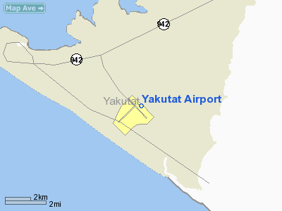
Yakutat, Alaska |
| Elevation AMSL |
33 ft / 10 m |
| Coordinates |
59°30′12″N 139°39′37″W / 59.50333°N 139.66028°W / 59.50333; -139.66028 |
| Runways |
| Direction |
Length |
Surface |
| ft |
m |
| 11/29 |
7,745 |
2,361 |
Asphalt |
| 2/20 |
6,475 |
1,974 |
Concrete |
| Statistics (2008) |
| Aircraft operations |
19,026 |
| Source: Federal Aviation Administration |
Yakutat Airport (IATA: YAK, ICAO: PAYA, FAA LID: YAK) is a state-owned public-use airport located three nautical miles (6 km) southeast of the central business district of Yakutat, a city in the U.S. state of Alaska. Facilities and aircraft
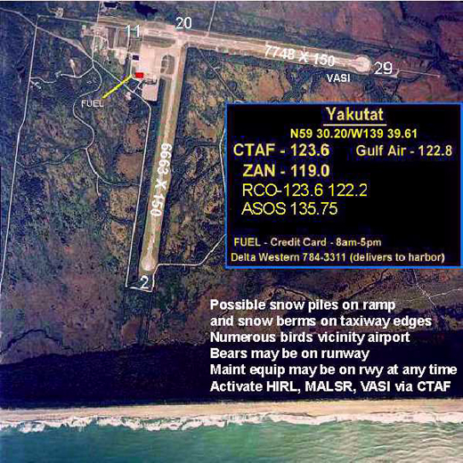
Yakutat Airport has two runways: 11/29 is 7,745 by 150 feet (2,361 x 46 m) with an asphalt surface; 2/20 is 6,475 by 150 feet (1,974 x 46 m) with an concrete surface. For the 12-month period ending May 2, 2008, the airport had 19,026 aircraft operations, an average of 52 per day: 68% general aviation, 26% air taxi, 4% scheduled commercial and 2% military.
Airline and destinations
| Airlines |
Destinations |
| Alaska Airlines |
Cordova, Juneau |
| Alsek Air Service |
Icy Bay, Yakataga |
Service to Icy Bay and Yakataga is subsidized by the United States Department of Transportation via the Essential Air Service program.
History
Yakutat Airport origins date from 1940 when Yakutat Army Airfield was constructed as part of the United States Army's long-range defense program for Alaska. During World War II the airfield was a key USAAF base during the Aleutian Campaign. It was used in combat by the 406th Bombardment Squadron (June–November 1942) (28th BG)
The above content comes from Wikipedia and is published under free licenses – click here to read more.
Location
& QuickFacts
|
FAA
Information Effective: |
2006-06-08 |
|
Airport
Identifier: |
YAK |
|
Longitude/Latitude: |
139-39-36.9000W/59-30-11.9000N
-139.660250/59.503306 (Estimated) |
|
Elevation: |
33 ft / 10.06 m (Surveyed) |
|
Land: |
0 acres |
|
From
nearest city: |
3 nautical miles SE of Yakutat, AK |
|
Location: |
Skagway-yakutat County, AK |
|
Magnetic Variation: |
23E (2005) |
Owner
& Manager
|
Ownership: |
Publicly owned |
|
Owner: |
St Of Ak Dot Se Reg |
|
Address: |
6860 Glacier Hwy
Juneau, AK 99801-7999 |
|
Phone number: |
907-465-1779 |
|
Manager: |
Robert Lekanof |
|
Address: |
Box 186
Yakutat, AK 99689 |
|
Phone number: |
907-784-3293 |
Airport
Operations and Facilities
|
Airport
Use: |
Open to public |
|
Wind
indicator: |
Yes |
|
Segmented
Circle: |
Yes |
|
Control
Tower: |
No |
|
Attendance
Schedule: |
ALL/ALL/0700-1730 |
|
Lighting
Schedule: |
DUSK-DAWN
ACTVT HIRL RYS 11/29 & 02/20; MALSR RYS 11 & 29;
VASI RY 29 & TWY LIGHTS - CTAF. |
|
Beacon
Color: |
Clear-Green (lighted land airport) |
|
Landing
fee charge: |
No |
|
Sectional
chart: |
Juneau |
|
Region: |
AAL - Alaska |
|
Boundary
ARTCC: |
ZAN - Anchorage |
|
Tie-in
FSS: |
JNU - Juneau |
|
FSS
Phone: |
907-586-7380 |
|
FSS
Toll Free: |
1-800-WX-BRIEF |
|
NOTAMs
Facility: |
YAK (NOTAM-d service avaliable) |
|
Certification
type/date: |
I AS 5/1973
ARFF INDEX A SVC AVBL DURING AIR CARRIER OPERATIONS ONLY.
CLOSED TO AIR CARRIER OPERATIONS WITH MORE THAN 30 PASSENGER
SEATS EXCEPT 24 HOURS PRIOR PERMISSION REQUIRED IN WRITING
TO AMGR PO BOX 186 YAKUTAT AK 99689. |
|
Federal Agreements: |
NGPY |
Airport
Communications
Airport
Services
|
Fuel
available: |
100 A1+
FUEL AVBL 24 HRS BY MAJOR CREDIT CARD PUMP.
FUEL
DISTRIBUTOR 907-784-3311. |
|
Airframe
Repair: |
NONE |
|
Power
Plant Repair: |
NONE |
|
Bottled
Oxygen: |
NONE |
|
Bulk
Oxygen: |
NONE |
|
Runway Information
Runway 02/20
|
Dimension: |
6475 x 150 ft / 1973.6 x 45.7 m |
|
Surface: |
CONC, Fair Condition |
|
Weight
Limit: |
Single wheel: 38000 lbs.
Dual wheel: 107000 lbs.
Dual
tandem wheel: 200000 lbs. |
|
Edge
Lights: |
High
HIRL RY 02/20 OTS OCT 1 THRU MAY 1.
& 02/20 CAUTION--RUNWAY LIGHTS 30 INCHES HIGH. |
|
|
Runway 02 |
Runway 20 |
|
Longitude: |
139-41-05.5133W |
139-39-36.8237W |
|
Latitude: |
59-29-46.5807N |
59-30-31.6889N |
|
Elevation: |
15.00 ft |
30.00 ft |
|
Alignment: |
45 |
127 |
|
Traffic
Pattern: |
Left |
Left |
|
Markings: |
Non-precision instrument, Poor Condition
/20 MARKINGS FADED. |
Non-precision instrument, Poor Condition |
|
Displaced
threshold: |
1388.00 ft |
0.00 ft |
|
Obstruction: |
42 ft brush, 1040.0 ft from runway, 20:1 slope
to clear |
15 ft brush, 500.0 ft from runway, 33:1 slope
to clear |
|
Runway 11/29
|
Dimension: |
7745 x 150 ft / 2360.7 x 45.7 m |
|
Surface: |
ASPH, Good Condition |
|
Surface
Treatment: |
Saw-cut or plastic Grooved |
|
Weight
Limit: |
Single wheel: 38000 lbs.
Dual wheel: 107000 lbs.
Dual
tandem wheel: 200000 lbs. |
|
Edge
Lights: |
High
HIRL RY 02/20 OTS OCT 1 THRU MAY 1.
& 02/20 CAUTION--RUNWAY LIGHTS 30 INCHES HIGH. |
|
|
Runway 11 |
Runway 29 |
|
Longitude: |
139-39-52.8826W |
139-38-06.7944W |
|
Latitude: |
59-30-41.2306N |
59-29-47.2730N |
|
Elevation: |
32.00 ft |
19.00 ft |
|
Alignment: |
127 |
127 |
|
ILS
Type: |
ILS |
|
|
Traffic
Pattern: |
Left |
Left |
|
Markings: |
Precision instrument, Fair Condition |
Precision instrument, Fair Condition |
|
VASI: |
|
4-box on left side |
|
RVR
Equipment: |
touchdown |
|
|
Approach
lights: |
MALSR |
MALSR |
|
Obstruction: |
, 50:1 slope to clear |
55 ft trees, 1800.0 ft from runway, 29:1 slope
to clear |
|
Radio Navigation
Aids
|
ID |
Type |
Name |
Ch |
Freq |
Var |
Dist |
|
OCC |
NDB |
Ocean Cape |
|
385.00 |
23E |
3.2 nm |
|
YAK |
VORTAC |
Yakutat |
080X |
113.30 |
23E |
0.6 nm |
Remarks
- CAUTION-
POSSIBLE SNOW PILES ON RAMP AND SNOW BERMS ON TWY EDGES OCT 1 THRU MAY
1.
- PARACHUTE
JUMPING ONTO ARPT RY; TWY & ACFT PARKING APRON PROHIBTED.
- PILOTS
ARE REQUESTED TO SELF-ANNOUNCE ON CTAF PRIOR TO TAXIING ON RWY FOR DEPARTURE;
LEAVING THE RWY AND WITHIN 10 NM OF THE ARPT WHEN APPROACHING TO LAND.
- TWY
'A1', 'D' & APRON 'B' CLSD TO ACFT 12500 LBS & OVR.
- ARPT
SAND LARGER GRADATION THAN FAA RECOMMENDED/SEE AC150/5200-30.
- SNOW
REMOVAL; ICE CONTROL & ARPT HAZARDOUS CONDS REPORTED ONLY DURG ARPT
MAINT DUTY HRS.
- RWY
2/20 NOT MAINTAINED OR MONITORED OCT 1 THRU MAY 1.
- NUMEROUS
BIRDS; BEAR AND MOOSE ON & INVOF RY.
- TWY
C CLSD DURG ACR OPNS UNTIL 15 MIN AFTER.
- RY
COND REPORTS REFLECT CONDS DURING ARPT MAINT DUTY HRS ONLY.
- ARPT
MAINT PERSONNEL & EQUIP MAY BE ON RY AT ANY TIME; RECOMMEND VISUAL
INSPN PRIOR TO USE; CTC NEAREST FSS FOR CURRENT NOTAM.
- SPB
ESTABD PRIOR TO 1959.
Based Aircraft
|
Aircraft
based on field: |
27 |
|
Single
Engine Airplanes: |
27 |
Major Carriers
Serving This Airport
Most Popular Destinations
|
Merle K (mudhole) Smith (CDV) |
50.0% |
| Juneau Intl (JNU) |
50.0% |
Most Popular Aircraft
|
N778AS |
4.9% |
| N703AS |
4.3% |
|
N763AS |
4.3% |
| N709AS |
4.3% |
|
N795AS |
3.3% |
| N706AS |
3.3% |
|
N793AS |
3.3% |
| N774AS |
2.7% |
|
N788AS |
2.7% |
| N776AS |
2.7% |
Operational Statistics
|
Aircraft
Operations: |
55/Day |
|
Air Carrier: |
3.7% |
|
Air Taxi: |
25.3% |
|
General
Aviation Local: |
15.2% |
|
General
Aviation Itinerant: |
50.6% |
|
Military: |
1.5% |
Yakutat Airport
Address:
Skagway-yakutat County, AK
Tel:
907-465-1779, 907-784-3293
Images
and information placed above are from
http://www.airport-data.com/airport/YAK/
We
thank them for the data!
| General
Info |
| Country |
United
States |
| State |
ALASKA
|
| FAA ID |
YAK
|
| Latitude |
59.503306
59� 30' 11.90" N |
| Longitude |
-139.660250
139� 39' 36.90" W |
| Elevation |
33 feet
10 meters |
| Type |
Civil
|
| Magnetic
Variation |
022� E
(01/06) |
| Beacon |
Yes
|
| Operating
Agency |
U.S.CIVIL
AIRPORT WHEREIN PERMIT COVERS USE BY TRANSIT MILITARY AIRCRAFT
|
| Daylight
Savings Time |
First
Sunday in April at 0200 to last Sunday in October at 0200 local time
(Exception Arizona and that portion of Indiana in the Eastern Time
Zone) |
We don't guarantee the information is fresh and accurate. The data may
be wrong or outdated.
For more up-to-date information please refer to other sources.
|
|


