 |
|
| Wrangell Airport |
 |
| IATA: WRG – ICAO: PAWG – FAA LID: WRG |
| Summary |
| Airport type |
Public |
| Operator |
State of Alaska DOT&PF |
| Location |
Wrangell, Alaska |
| Elevation AMSL |
44 ft / 13.4 m |
| Coordinates |
56°29′04″N 132°22′11″W / 56.48444°N 132.36972°W / 56.48444; -132.36972Coordinates: 56°29′04″N 132°22′11″W / 56.48444°N 132.36972°W / 56.48444; -132.36972 |
| Runways |
| Direction |
Length |
Surface |
| ft |
m |
| 10/28 |
5,999 |
1,828 |
Asphalt |
Wrangell Airport (IATA: WRG, ICAO: PAWG, FAA LID: WRG) is a public airport located one mile (2 km) northeast of the central business district (CBD) of Wrangell, a city in the Wrangell-Petersburg Census Area of the U.S. state of Alaska. The airport has a single runway. Airline service is subsidized by the Essential Air Service program.
Airline and destinations
- Alaska Airlines (Juneau, Ketchikan, Petersburg)
The above content comes from Wikipedia and is published under free licenses – click here to read more.
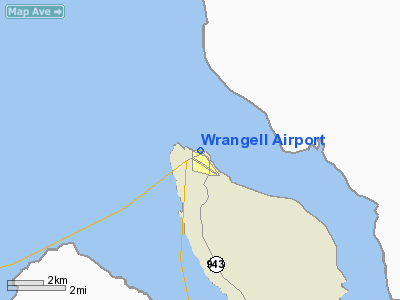
Location
& QuickFacts
|
FAA
Information Effective: |
2006-06-08 |
|
Airport
Identifier: |
WRG |
|
Longitude/Latitude: |
132-22-11.4000W/56-29-03.6000N
-132.369833/56.484333 (Estimated) |
|
Elevation: |
44 ft / 13.41 m (Surveyed) |
|
Land: |
0 acres |
|
From
nearest city: |
1 nautical miles NE of Wrangell, AK |
|
Location: |
Wrangell-petersburg County, AK |
|
Magnetic Variation: |
27E (1985) |
Owner
& Manager
|
Ownership: |
Publicly owned |
|
Owner: |
St Of Ak Dot/se Region |
|
Address: |
6860 Glacier Hwy
Juneau, AK 99801-7999 |
|
Phone number: |
907-465-1779 |
|
Manager: |
Pat Taylor |
|
Address: |
Box 1351
Wrangell, AK 99929 |
|
Phone number: |
907-874-3107 |
Airport
Operations and Facilities
|
Airport
Use: |
Open to public |
|
Wind
indicator: |
Yes |
|
Segmented
Circle: |
Yes |
|
Control
Tower: |
No |
|
Attendance
Schedule: |
ALL/ALL/0800-1700 |
|
Lighting
Schedule: |
DUSK-DAWN
ACTVT HIRL RY 10/28; REIL & VASI RYS 10 & 28 - 122.6. |
|
Beacon
Color: |
Clear-Green (lighted land airport) |
|
Sectional
chart: |
Juneau |
|
Region: |
AAL - Alaska |
|
Boundary
ARTCC: |
ZAN - Anchorage |
|
Tie-in
FSS: |
SIT - Sitka |
|
FSS
on Airport: |
No |
|
FSS
Phone: |
907-966-2221 |
|
FSS
Toll Free: |
1-800-478-6300 |
|
Alternate
FSS: |
JNU - Juneau |
|
Alt.
FSS Toll Free: |
1-800-WX-BRIEF |
|
NOTAMs
Facility: |
WRG (NOTAM-d service avaliable) |
|
Certification
type/date: |
I AS 5/1973
ARFF SERVICES ARE ONLY AVBL DURING SCHEDULED ACR OPNS. ARFF
SERVICES ARE ONLY AVBL DURING SCHED ACR OPERATIONS. |
|
Federal Agreements: |
NGY |
Airport
Communications
Airport
Services
|
Fuel
available: |
100LLA
FOR FUEL CALL 907-874-2388. |
|
Airframe
Repair: |
MINOR |
|
Power
Plant Repair: |
MINOR |
|
Bottled
Oxygen: |
NONE |
|
Bulk
Oxygen: |
NONE |
|
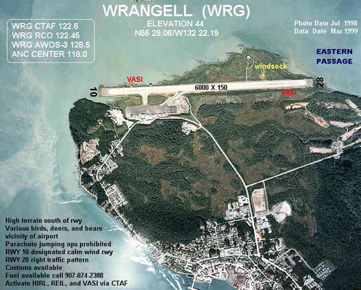
Runway Information
Runway 10/28
|
Dimension: |
5999 x 150 ft / 1828.5 x 45.7 m |
|
Surface: |
ASPH, Good Condition
RY 10/28 SHALLOW DEPRESSIONS 40 FT IN DIA 925 FT FM APCH END RY
28 N SIDE.
STANDING WATER AFTER RAIN. |
|
Surface
Treatment: |
Saw-cut or plastic Grooved |
|
Weight
Limit: |
Single wheel: 75000 lbs.
Dual wheel: 175000 lbs.
Dual
tandem wheel: 300000 lbs. |
|
Edge
Lights: |
High |
|
|
Runway 10 |
Runway 28 |
|
Longitude: |
132-22-56.9970W |
132-21-25.7858W |
|
Latitude: |
56-29-18.9564N |
56-28-48.1738N |
|
Elevation: |
26.00 ft |
44.00 ft |
|
Alignment: |
121 |
127 |
|
ILS
Type: |
LDA/DME |
|
|
Traffic
Pattern: |
Left |
Right |
|
Markings: |
Precision instrument, Good Condition |
Precision instrument, Good Condition |
|
Crossing
Height: |
52.00 ft |
52.00 ft |
|
VASI: |
4-box on left side |
4-box on left side |
|
Visual
Glide Angle: |
3.00� |
3.00� |
|
Runway
End Identifier: |
Yes |
Yes |
|
Obstruction: |
270 ft hill, 700.0 ft from runway, 1150 ft
right of centerline, 1:1 slope to clear |
357 ft trees, 8910.0 ft from runway, 1000 ft
left of centerline, 24:1 slope to clear |
|
Radio Navigation
Aids
|
ID |
Type |
Name |
Ch |
Freq |
Var |
Dist |
|
FPN |
NDB |
Fredericks Point |
|
372.00 |
28E |
23.8 nm |
|
SQM |
NDB |
Sumner Strait |
|
529.00 |
28E |
24.2 nm |
|
LVD |
VOR/DME |
Level Island |
112X |
116.50 |
28E |
23.7 nm |
Remarks
- RY
10 DESIGNATED AS CALM WIND RY.
- ARPT
MAINT PERSONNEL & EQUIP MAY BE ON RY AT ANY TIME; RECOMMEND VISUAL
INSPN PRIOR TO USE; CTC NEAREST FSS FOR CURRENT NOTAMS.
- PARACHUTE
JUMPING ONTO ARPT RY; TWY & ACFT PARKING APRON PROHIBITED.
- PILOTS
ARE REQUESTED TO SELF-ANNOUNCE ON COMMON TRAFFIC ADVISORY FREQ (CTAF)
BEFORE TAXIING ON THE RY FOR DEP; LEAVING THE RY AND WITHIN 5 NM OF
THE ARPT WHEN APPROACHING TO LAND.
- TWY
B CLSD TO ACFT OVER 12,500 GWT.
- SHALLOW
DEPRESSIONS 40 FT IN DIAM 925 FT FM AER 28 N SIDE. STANDING
WATER AFT RAIN.
- BE
ALERT: BLASTING SFC TO 125 FT AGL INVOF AER 10. CTC SIT FSS FOR SCHEDULE
TIMES.
- LEVEL
ISLAND WX CAMERAS AVBL ON INTERNET AT HTTP://AKWEATHERCAMS.FAA.GOV
- ARPT
SAND LARGER GRADATION THAN FAA RECOMMENDED/SEE AC150/5200-30.
- OFF
ARPT SOLID WASTE LANDFILL APRXLY 2000 FT SW OF RY 10 LNDG THLD.
- RY
10/28 GRVD FULL LENGTH.
- SNOW
REMOVAL; ICE CONTROL & ARPT HAZARDOUS CONDS REPORTED ONLY DURG ARPT
MAINT DUTY HRS.
- ARFF
EQUIPMENT STAFFED DURING PERIODS OF ACR ACTIVITY ONLY.
- HIGH
TERRAIN IMMEDIATELY SOUTH OF RY.
- AIRPORT
MAINTENANCE DUTY HRS 0700-1500.
- RY
COND REPORTS REFLECT CONDS DURING ARPT MAINT DUTY HRS ONLY.
Based Aircraft
|
Aircraft
based on field: |
16 |
|
Single
Engine Airplanes: |
16 |
Major Carriers
Serving This Airport
Most Popular Destinations
| Ketchikan Intl (KTN) |
50.0% |
|
Petersburg James A Johnson (PSG) |
50.0% |
Most Popular Aircraft
|
N763AS |
6.0% |
| N775AS |
4.3% |
|
N776AS |
4.3% |
| N778AS |
3.8% |
|
N788AS |
3.3% |
| N795AS |
3.3% |
|
N773AS |
2.7% |
| N756AS |
2.7% |
|
N709AS |
2.7% |
| N618AS |
2.2% |
Operational Statistics
|
Aircraft
Operations: |
225/Week |
|
Air Carrier: |
6.2% |
|
Air Taxi: |
53.2% |
|
General
Aviation Local: |
8.6% |
|
General
Aviation Itinerant: |
25.8% |
Wrangell Airport
Address:
Wrangell-petersburg County, AK
Tel:
907-465-1779, 907-874-3107
Images
and information placed above are from
http://www.airport-data.com/airport/WRG/
We
thank them for the data!
| General
Info |
| Country |
United
States |
| State |
ALASKA
|
| FAA ID |
WRG
|
| Latitude |
56-29-03.573N
|
| Longitude |
132-22-11.367W
|
| Elevation |
44 feet
|
| Near City |
WRANGELL
|
We don't guarantee the information is fresh and accurate. The data may
be wrong or outdated.
For more up-to-date information please refer to other sources.
|
|


