 |
|
| Whittier Airport |
| IATA: none – ICAO: PAWR – FAA LID: IEM |
| Summary |
| Airport type |
Public |
| Owner |
Alaska DOT&PF - Central Region |
| Serves |
Whittier, Alaska |
| Elevation AMSL |
30 ft / 8 m |
| Coordinates |
60°46′38″N 148°43′18″W / 60.77722°N 148.72167°W / 60.77722; -148.72167 |
| Runways |
| Direction |
Length |
Surface |
| ft |
m |
| 3/21 |
1,480 |
451 |
Gravel |
| Statistics (2005) |
| Aircraft operations |
770 |
| Based aircraft |
2 |
| Source: Federal Aviation Administration |
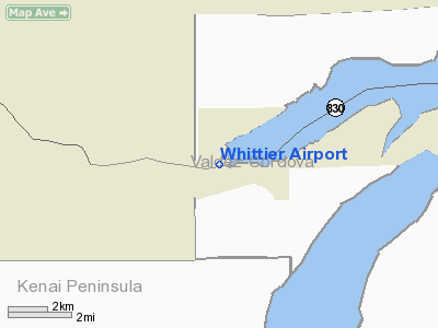
Whittier Airport (ICAO: PAWR, FAA LID: IEM) is a state-owned public-use airport located one nautical mile (1.85 km) northwest of the central business district of Whittier, a city in the Valdez-Cordova Census Area of the U.S. state of Alaska. The airport is situated on the northeast shore of the Kenai Peninsula.
Although most U.S. airports use the same three-letter location identifier for the FAA and IATA, this airport is assigned IEM by the FAA but has no designation from the IATA. The airport's ICAO identifier is PAWR.
Facilities and aircraft
Whittier Airport has one runway designated 3/21 with a gravel surface measuring 1,480 by 58 feet (451 x 18 m). For the 12-month period ending December 31, 2005, the airport had 700 aircraft operations, an average of 64 per month: 97% general aviation and 3% air taxi.At that time there were two single-engine aircraft based at this airport. The run way 500 feet longer but was damaged by the 1964 Good Friday Earthquake.
The above content comes from Wikipedia and is published under free licenses – click here to read more.
Location
& QuickFacts
|
FAA
Information Effective: |
2006-06-08 |
|
Airport
Identifier: |
IEM |
|
Longitude/Latitude: |
148-43-17.6790W/60-46-37.9650N
-148.721577/60.777212 (Estimated) |
|
Elevation: |
30 ft / 9.14 m (Estimated) |
|
Land: |
0 acres |
|
From
nearest city: |
1 nautical miles NW of Whittier, AK |
|
Location: |
Valdez-chitna-whitie County, AK |
|
Magnetic Variation: |
25E (1985) |
Owner
& Manager
|
Ownership: |
Publicly owned |
|
Owner: |
St Of Ak Dot/pf Central Reg |
|
Address: |
Po Box 196900
Anchorage, AK 99519-6900 |
|
Phone
number: |
907-269-0767 |
|
Manager: |
Larry Bushnell |
|
Address: |
State Of Ak Dot
Girdwood, AK 99587 |
|
Phone number: |
907-783-2232 |
Airport
Operations and Facilities
|
Airport
Use: |
Open to public |
|
Wind
indicator: |
Yes
WIND SOCK UNUSABLE. |
|
Segmented
Circle: |
No |
|
Control
Tower: |
No |
|
Attendance
Schedule: |
UNATNDD |
|
Landing
fee charge: |
No |
|
Sectional
chart: |
Anchorage |
|
Region: |
AAL - Alaska |
|
Boundary
ARTCC: |
ZAN - Anchorage |
|
Tie-in
FSS: |
ENA - Kenai |
|
FSS
on Airport: |
No |
|
FSS
Phone: |
800-478-3576 |
|
FSS
Toll Free: |
1-800-WX-BRIEF |
|
NOTAMs
Facility: |
IEM (NOTAM-d service avaliable) |
|
Federal Agreements: |
N |
Airport
Communications
Airport
Services
|
Airframe
Repair: |
NONE |
|
Power
Plant Repair: |
NONE |
|
Bottled
Oxygen: |
NONE |
|
Bulk
Oxygen: |
NONE |
|
Runway Information
Runway 03/21
|
Dimension: |
1480 x 58 ft / 451.1 x 17.7 m |
|
Surface: |
GRAVEL, Fair Condition
RWY 03/21 ROCKS TO 4 INCHES ON RWY. |
|
|
Runway 03 |
Runway 21 |
|
Traffic
Pattern: |
Left |
Left |
|
Obstruction: |
12 ft brush, 40.0 ft from runway, 3:1 slope
to clear |
, 0.0 ft from runway, 50:1 slope to clear |
|
Radio Navigation
Aids
|
ID |
Type |
Name |
Ch |
Freq |
Var |
Dist |
|
CMQ |
NDB |
Campbell Lake |
|
338.00 |
21E |
45.3 nm |
|
BOB |
NDB |
Bruck |
|
387.00 |
21E |
48.5 nm |
|
EDF |
TACAN |
Elmendorf |
081X |
|
21E |
41.9 nm |
|
ANC |
VOR/DME |
Anchorage |
090X |
114.30 |
25E |
48.8 nm |
|
MRI |
VOT |
Merrill |
|
111.00 |
|
42.0 nm |
|
ANC |
VOT |
Anchorage |
|
108.40 |
|
43.9 nm |
Remarks
- APCH
TO RWY 21 OVER WATER.
- (A30-3)
FOR TKOF USE RWY 03 ONLY; FOR LNDGS USE RWY 21 ONLY.
- PILOTS
ARE REQUESTED TO SELF-ANNOUNCE ON CTAF PRIOR TO TAXIING ON RWY FOR DEPARTURE;
LEAVING THE RWY AND WITHIN 10 NM OF THE ARPT WHEN APPROACHING TO LAND.
- WHITTIER
AND PORTAGE GLACIER WX CAMERA AVBL ON INTERNET AT HTTP://AKWEATHERCAMS.FAA.GOV
- NO
WINTER MAINT. CLSD FROM FIRST SNOWFALL TIL AFTER BREAKUP.
- WHEN
AVBL WEA RPRTS HRLYONLY.
- CAUTION
ADVISED RWY CONDITION NOT MONITORED. RECOMMEND VISUAL INSPECTION PRIOR
TO LANDING.
- CAUTION:
BIRD ACTIVITY IN ARPT AREA.
- RWY
03 SLOPES TOWARDS WATER AT -2%.
Based Aircraft
|
Aircraft
based on field: |
2 |
|
Single
Engine Airplanes: |
2 |
Operational Statistics
|
Aircraft
Operations: |
15/Week |
|
Air Taxi: |
2.6% |
|
General
Aviation Local: |
90.9% |
|
General
Aviation Itinerant: |
6.5% |
Whittier Airport
Address:
Valdez-chitna-whitie County, AK
Tel:
907-269-0767,
907-783-2232
Images
and information placed above are from
http://www.airport-data.com/airport/IEM/
We
thank them for the data!
| General
Info |
| Country |
United
States |
| State |
ALASKA
|
| FAA ID |
IEM
|
| Latitude |
60-46-37.965N
|
| Longitude |
148-43-17.679W
|
| Elevation |
30 feet
|
| Near City |
WHITTIER
|
We don't guarantee the information is fresh and accurate. The data may
be wrong or outdated.
For more up-to-date information please refer to other sources.
|
|


