|
|
| Wasilla Airport |
 |
| IATA: WWA – ICAO: PAWS – FAA LID: IYS |
| Summary |
| Airport type |
Public |
| Owner |
City of Wasilla |
| Serves |
Wasilla, Alaska |
| Elevation AMSL |
354 ft / 108 m |
| Coordinates |
61°34′19″N 149°32′22″W / 61.57194°N 149.53944°W / 61.57194; -149.53944 |
| Website |
www.CityOfWasilla.com/... |
| Runways |
| Direction |
Length |
Surface |
| ft |
m |
| 3/21 |
3,700 |
1,128 |
Asphalt |
| 3S/21S |
1,690 |
515 |
Turf/Gravel |
| Statistics |
| Based aircraft |
100 |
| Source: Federal Aviation Administration |
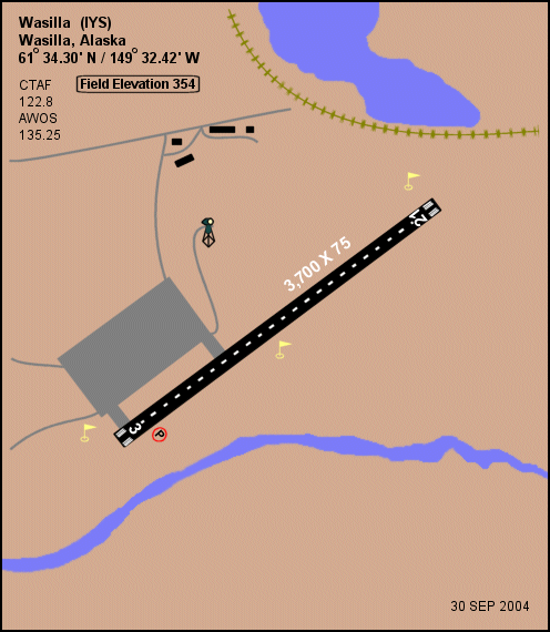
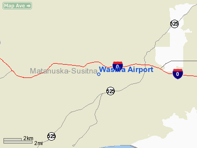
Wasilla Airport (IATA: WWA, ICAO: PAWS, FAA LID: IYS) is a city-owned public-use airport located three nautical miles (6 km) west of the central business district of Wasilla, a city in the Matanuska-Susitna Borough of the U.S. state of Alaska. Wasilla is 17 miles by air and 47 miles by road from Anchorage, the largest city in Alaska.
Facilities and aircraft
Wasilla Airport has an asphalt paved runway designated 3/21 which measures 3,700 by 75 feet (1,128 x 23 m). It also has a turf and gravel runway (3S/21S) which is 1,690 by 60 feet (515 x 18 m). There are 100 aircraft based at this airport, all single-engine.
The airport is open year round and has radio controlled runway, taxiway and security lighting. It offers engine and airframe repair, fuel, and air-taxi services.
The above content comes from Wikipedia and is published under free licenses – click here to read more.
Location & QuickFacts
|
FAA
Information Effective: |
2006-06-08 |
|
Airport
Identifier: |
IYS |
|
Longitude/Latitude: |
149-32-25.0610W/61-34-17.9740N
-149.540295/61.571659 (Estimated) |
|
Elevation: |
354 ft / 107.90 m (Surveyed) |
|
Land: |
0 acres |
|
From
nearest city: |
3 nautical miles W of Wasilla, AK |
|
Location: |
Mata-sus Borough County, AK |
|
Magnetic Variation: |
23E (2000) |
Owner
& Manager
|
Ownership: |
Publicly owned |
|
Owner: |
City Of Wasilla |
|
Address: |
290 E Hering Ave
Wasilla, AK 99687 |
|
Phone
number: |
907-373-9050 |
|
Manager: |
Mr Tom Westall |
|
Address: |
290 E Hering Ave
Wasila, AK 99687 |
|
Phone number: |
907-376-6897
DEPT OF PUBLIC WORKS |
Airport Operations
and Facilities
|
Airport
Use: |
Open to public |
|
Wind
indicator: |
Yes |
|
Segmented Circle: |
Yes |
|
Control
Tower: |
No |
|
Attendance Schedule: |
UNATNDD |
|
Lighting
Schedule: |
DUSK-DAWN
ACTVT MIRL RY 03/21 - 122.8 |
|
Beacon
Color: |
Clear-Green (lighted land airport) |
|
Sectional chart: |
Anchorage |
|
Region: |
AAL - Alaska |
|
Boundary
ARTCC: |
ZAN - Anchorage |
|
Tie-in
FSS: |
ENA - Kenai |
|
FSS
Phone: |
800-478-3576 |
|
FSS
Toll Free: |
1-800-WX-BRIEF |
|
NOTAMs
Facility: |
IYS (NOTAM-d service avaliable) |
|
Federal Agreements: |
NGY |
Airport
Communications
Airport Services
|
Fuel
available: |
100LL |
|
Airframe
Repair: |
MAJOR |
|
Power
Plant Repair: |
MAJOR |
|
Runway Information
Runway 03/21
|
Dimension: |
3700 x 75 ft / 1127.8 x 22.9 m |
|
Surface: |
ASPH, Fair Condition |
|
Edge
Lights: |
Medium |
|
|
Runway 03 |
Runway 21 |
|
Longitude: |
149-32-56.8250W |
149-31-53.2970W |
|
Latitude: |
61-34-07.8480N |
61-34-28.0990N |
|
Elevation: |
336.00 ft |
354.00 ft |
|
Alignment: |
56 |
127 |
|
Traffic
Pattern: |
Right |
Left |
|
Crossing
Height: |
25.00 ft |
0.00 ft |
|
VASI: |
4-light PAPI on right side |
|
|
Visual
Glide Angle: |
3.00� |
0.00� |
|
Obstruction: |
34 ft trees, 1281.0 ft from runway, 22 ft right of centerline,
31:1 slope to clear |
46 ft trees, 1332.0 ft from runway, 24:1 slope to clear |
|
Radio Navigation Aids
|
ID |
Type |
Name |
Ch |
Freq |
Var |
Dist |
|
CMQ |
NDB |
Campbell Lake |
|
338.00 |
21E |
28.2 nm |
|
BOB |
NDB |
Bruck |
|
387.00 |
21E |
30.4 nm |
|
PEE |
NDB |
Peters Creek |
|
305.00 |
26E |
48.3 nm |
|
EDF |
TACAN |
Elmendorf |
081X |
|
21E |
20.1 nm |
|
ANC |
VOR/DME |
Anchorage |
090X |
114.30 |
25E |
31.8 nm |
|
TKA |
VOR/DME |
Talkeetna |
109X |
116.20 |
26E |
46.5 nm |
|
BGQ |
VORTAC |
Big Lake |
072X |
112.50 |
25E |
12.2 nm |
|
MRI |
VOT |
Merrill |
|
111.00 |
|
23.2 nm |
|
ANC |
VOT |
Anchorage |
|
108.40 |
|
26.9 nm |
Remarks
- RY
CONDITION NOT MONITORED RECOMMEND VISUAL INSPECTION PRIOR TO USE.
- NUMEROUS
PVT ARPTS AND LAKES IN VCNTY. ARPT RESTRICTED TO ACFT WITH APPROACH
SPEEDS LESS THAN 121 KTS.
- ACTVT
AWOS - 135.25.
- ULTRALIGHTS
ON AND IN VICINITY OF AIRPORT.
- SHEEP
MOUNTAIN WX CAMERA AVBL ON INTERNET AT HTTP://AKWEATHERCAMS.FAA.GOV
- AIRSPACE
DETERMINATION PENDING
Based Aircraft
|
Aircraft
based on field: |
100 |
|
Single
Engine Airplanes: |
100 |
Wasilla Airport
Address:
Mata-sus Borough County, AK
Tel:
907-373-9050,
907-376-6897
Images
and information placed above are from
http://www.airport-data.com/airport/IYS/
We
thank them for the data!
| General Info
|
| Country |
United States |
| State |
ALASKA |
| FAA ID |
IYS |
| Latitude |
61-34-17.290N |
| Longitude |
149-32-26.230W |
| Elevation |
348 feet |
| Near City |
WASILLA |
We don't guarantee the information is fresh and accurate. The data may
be wrong or outdated.
For more up-to-date information please refer to other sources.
|
|