 |
|
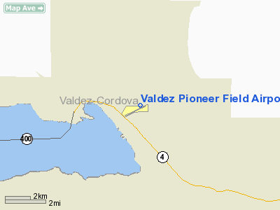
Valdez Pioneer Field Airport |
Valdez Airport
Pioneer Field |
| IATA: VDZ – ICAO: PAVD – FAA LID: VDZ |
| Summary |
| Airport type |
Public |
| Operator |
State of Alaska DOT&PF - Northern Region |
| Serves |
Valdez, Alaska |
| Elevation AMSL |
121 ft / 37 m |
| Coordinates |
61°08′02″N 146°14′54″W / 61.13389°N 146.24833°W / 61.13389; -146.24833 |
| Runways |
| Direction |
Length |
Surface |
| ft |
m |
| 6/24 |
6,500 |
1,981 |
Asphalt |
| Statistics (2008) |
| Aircraft operations |
13,000 |
| Based aircraft |
31 |
| Source: Federal Aviation Administration |
Valdez Airport (IATA: VDZ, ICAO: PAVD, FAA LID: VDZ), also known as Pioneer Field, is a state-owned public-use airport located three nautical miles (6 km) east of the central business district of Valdez, a city in the Valdez-Cordova Census Area of the U.S. state of Alaska. Facilities and aircraft
Valdez Airport covers an area of 140 acres (57 ha) at an elevation of 121 feet (37 m) above mean sea level. It has one asphalt paved runway designated 6/24 which measures 6,500 by 150 feet (1,981 x 46 m).
For the 12-month period ending January 1, 2008, the airport had 13,000 aircraft operations, an average of 35 per day: 50% air taxi, 42% general aviation and 8% military. At that time there were 31 aircraft based at this airport: 65% single-engine, 3% jet, 23% helicopter and 10% ultralight.
Airline and destination
The above content comes from Wikipedia and is published under free licenses – click here to read more.
Location
& QuickFacts
|
FAA
Information Effective: |
2006-06-08 |
|
Airport
Identifier: |
VDZ |
|
Longitude/Latitude: |
146-14-54.0250W/61-08-02.2200N
-146.248340/61.133950 (Estimated) |
|
Elevation: |
118 ft / 35.97 m (Surveyed) |
|
Land: |
140 acres |
|
From
nearest city: |
3 nautical miles E of Valdez, AK |
|
Location: |
Valdez-chitna-whitie County, AK |
|
Magnetic Variation: |
22E (2005) |
Owner
& Manager
|
Ownership: |
Publicly owned |
|
Owner: |
St Of Ak Dotpf Nor Reg |
|
Address: |
2381 Peger Road
Fairbanks, AK 99709 |
|
Phone number: |
907-451-5217 |
|
Manager: |
Steve Searles |
|
Address: |
Box 507
Valdez, AK 99686 |
|
Phone number: |
907-835-5658
OTHER PHONE NUMBERS AVBL 835-4695/5658. |
Airport
Operations and Facilities
|
Airport
Use: |
Open to public |
|
Wind
indicator: |
Yes |
|
Segmented
Circle: |
Yes |
|
Control
Tower: |
No |
|
Attendance
Schedule: |
907-835-5658 |
|
Lighting
Schedule: |
24 HRS
ACTVT HIRL RY 06/24; MALSF RY 06 & REIL RY 24; PAPI
RY 06 - CTAF. |
|
Beacon
Color: |
Clear-Green (lighted land airport) |
|
Landing
fee charge: |
No |
|
Sectional
chart: |
Anchorage |
|
Region: |
AAL - Alaska |
|
Boundary
ARTCC: |
ZAN - Anchorage |
|
Tie-in
FSS: |
JNU - Juneau |
|
FSS
on Airport: |
No |
|
FSS
Phone: |
907-586-7380 |
|
FSS
Toll Free: |
1-800-WX-BRIEF |
|
NOTAMs
Facility: |
VDZ (NOTAM-d service avaliable) |
|
Certification
type/date: |
I AS 2/1977
CLSD TO ACR OPNS WITH MORE THAN 30 PSGR SEATS EXCP WITH
PPR IN WRITING TO AMGR; PO BOX 507 VALDEZ AK 99686; 24 HRS
IN ADVANCE; FAX 907-835-5849. |
|
Federal Agreements: |
NGY |
Airport
Communications
Airport
Services
|
Fuel
available: |
100LLB |
|
Airframe
Repair: |
MINOR |
|
Power
Plant Repair: |
MINOR |
|
Bottled
Oxygen: |
NONE |
|
Bulk
Oxygen: |
NONE |
|
Runway Information
Runway 06/24
|
Dimension: |
6508 x 150 ft / 1983.6 x 45.7 m |
|
Surface: |
ASPH, Good Condition |
|
Surface
Treatment: |
Saw-cut or plastic Grooved |
|
Edge
Lights: |
High |
|
|
Runway 06 |
Runway 24 |
|
Longitude: |
146-15-59.5300W |
146-13-48.5200W |
|
Latitude: |
61-07-57.3600N |
61-08-07.0800N |
|
Elevation: |
39.00 ft |
118.00 ft |
|
Alignment: |
81 |
127 |
|
ILS
Type: |
LDA/DME |
|
|
Traffic
Pattern: |
Right |
Left |
|
Markings: |
Precision instrument, Good Condition |
Non-precision instrument, Good Condition |
|
Crossing
Height: |
29.00 ft |
0.00 ft |
|
VASI: |
4-light PAPI on left side |
|
|
Visual
Glide Angle: |
3.00� |
0.00� |
|
Approach
lights: |
MALSR |
|
|
Runway
End Identifier: |
No |
Yes |
|
Obstruction: |
75 ft trees, 2450.0 ft from runway, 30:1 slope
to clear |
50 ft trees, 1700.0 ft from runway, 30:1 slope
to clear |
|
Radio Navigation
Aids
|
ID |
Type |
Name |
Ch |
Freq |
Var |
Dist |
|
MNL |
NDB |
Mineral Creek |
|
524.00 |
27E |
3.1 nm |
|
ALJ |
NDB |
Orca Bay |
|
233.00 |
23E |
40.6 nm |
|
GCR |
NDB |
Glacier River |
|
404.00 |
22E |
44.4 nm |
|
HBK |
NDB |
Hinchinbrook |
|
362.00 |
27E |
44.7 nm |
|
JOH |
VOR/DME |
Johnstone Point |
114X |
116.70 |
27E |
40.6 nm |
Remarks
- FLIGHT
NOTIFICATION SERVICE AVBL.
- ARPT
MAINT DUTY HRS 0600-1630 WINTER; 0700-1730 SUMMER.
- SNOW
& ICE REMOVAL ONLY PERFORMED DURING DUTY HRS UNLESS BY PRIOR ARRANGEMENT
IN WRITING WITH ARPT MANAGEMENT.
- BE
ALERT - DURG STRONG NORTHERLY WINDS THE WINDS AT MIDFIELD AND AT THE
EAST END OF THE RY MAY BE SIGNIFICANTLY HIGHER THAN THE WINDS DETECTED
AT THE AWOS SITE.
- BE
ALERT: SEE SPECIAL NOTICES - PORT VALDEZ AREA AND GENERAL NOTICES -
THOMPSON PASS AVALANCHE CONTROL.
- POTATO
POINT WX CAMERA AVBL ON INTERNET AT HTTP://AKWEATHERCAMS.FAA.GOV
- TAXIWAY
D CLOSED INDEFINITELY
- ARPT
SAND LARGER GRADATION THAN FAA RECOMMENDED/SEE AC150/5200-30.
Based Aircraft
|
Aircraft
based on field: |
24 |
|
Single
Engine Airplanes: |
20 |
|
Helicopters: |
4 |
Operational Statistics
|
Aircraft
Operations: |
250/Week |
|
Air Taxi: |
50.0% |
|
General
Aviation Local: |
19.2% |
|
General
Aviation Itinerant: |
23.1% |
|
Military: |
7.7% |
Valdez Pioneer Field Airport
Address:
Valdez-chitna-whitie County, AK
Tel:
907-451-5217, 907-835-5658
Images
and information placed above are from
http://www.airport-data.com/airport/VDZ/
We
thank them for the data!
| General
Info |
| Country |
United
States |
| State |
ALASKA
|
| FAA ID |
VDZ
|
| Latitude |
61-08-02.221N
|
| Longitude |
146-14-54.096W
|
| Elevation |
120 feet
|
| Near City |
VALDEZ
|
We don't guarantee the information is fresh and accurate. The data may
be wrong or outdated.
For more up-to-date information please refer to other sources.
|
|


