|
|
Unalaska Airport
Dutch Harbor Airport
Tom Madsen Airport |
 |
| IATA: DUT – ICAO: PADU – FAA LID: DUT |
| Summary |
| Airport type |
Public |
| Owner |
State of Alaska DOT&PF - Central Region |
| Serves |
Unalaska, Alaska |
| Location |
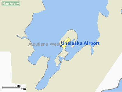
Amaknak Island |
| Hub for |
PenAir |
| Elevation AMSL |
22 ft / 7 m |
| Coordinates |
53°54′00″N 166°32′37″W / 53.9°N 166.54361°W / 53.9; -166.54361 |
| Runways |
| Direction |
Length |
Surface |
| ft |
m |
| 12/30 |
3,900 |
1,189 |
Asphalt |
| Statistics (2007) |
| Aircraft operations |
744 |
| Source: Federal Aviation Administration |
Unalaska Airport (IATA: DUT, ICAO: PADU, FAA LID: DUT) is a public airport in the City of Unalaska, on Amaknak Island in the Aleutian Islands, off the coast of the U.S. state of Alaska. It is located 50 miles from the Great Circle route to the Orient on the Bering Sea coast of Unalaska Island, 800 air miles southwest of Anchorage and 1,950 miles from Seattle.
The official name of the City of Unalaska's port is Dutch Harbor. That name is also applied to the portion of Unalaska on Amaknak Island, which is located across a bridge from the rest of the city on Unalaska Island. Therefore the airport is sometimes referred to as Dutch Harbor Airport.
In 2002, the State of Alaska renamed it Tom Madsen Airport in honor of Charles Thomas Madsen Sr., a bush pilot who was killed in an airplane accident that year. However, the Federal Aviation Administration still refers to it as Unalaska Airport.
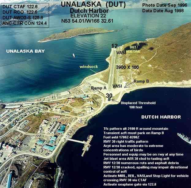
The airport's runway is bordered on one side by a steep drop off into the ocean and the side of a hill on the other. Both ends drop off into open water.
Scheduled commercial airline service is provided by PenAir, a code share partner of Alaska Airlines. Airlines and destinations
- PenAir (Akutan, Anchorage, Cold Bay, Nikolski, Sand Point)
Facilities and aircraft
Unalaska Airport has one runway designated 12/30 with an asphalt surface measuring 3,900 by 100 feet (1,189 x 30 m). For the 12-month period ending December 31, 2007, the airport had 744 aircraft operations, an average of 62 per month: 80% scheduled commercial, 13% air taxi and 7% general aviation. There is a microwave landing system (MLS) approach.
The above content comes from Wikipedia and is published under free licenses – click here to read more.
Location
& QuickFacts
|
FAA
Information Effective: |
2006-06-08 |
|
Airport
Identifier: |
DUT |
|
Longitude/Latitude: |
166-32-36.6000W/53-54-00.5000N
-166.543500/53.900139 (Estimated) |
|
Elevation: |
22 ft / 6.71 m (Surveyed) |
|
Land: |
0 acres |
|
From
nearest city: |
1 nautical miles N of Unalaska, AK |
|
Location: |
Aleutian Islands County, AK |
|
Magnetic Variation: |
14E (1985) |
Owner
& Manager
|
Ownership: |
Publicly owned |
|
Owner: |
State Of Ak Dotpf-central Rgn |
|
Address: |
Po Box 196900
Anchorage, AK 99519 |
|
Phone
number: |
907-269-0749 |
|
Manager: |
Steve Berninger |
|
Address: |
920525
Dutch Harbor, AK 99692 |
|
Phone
number: |
907-581-1786 |
Airport
Operations and Facilities
|
Airport
Use: |
Open to public |
|
Wind
indicator: |
Yes |
|
Segmented
Circle: |
Yes |
|
Control
Tower: |
No |
|
Attendance
Schedule: |
ALL/ALL/0800-1630 |
|
Lighting
Schedule: |
DUSK-DAWN
FOR MIRL RY 12/30; VASI & REIL RYS 12 & 30; STOP
LGT FOR VEH TFC CROSSING RY 30 THR; KEY 122.6 7 TIMES FOR
ON; 3 TIMES FOR STOP LGT & REIL OFF. |
|
Beacon
Color: |
Clear-Green (lighted land airport) |
|
Landing
fee charge: |
No |
|
Sectional
chart: |
Dutch Harbor |
|
Region: |
AAL - Alaska |
|
Traffic
Pattern Alt: |
2078 ft |
|
Boundary
ARTCC: |
ZAN - Anchorage |
|
Tie-in
FSS: |
CDB - Cold Bay
COLD BAY FSS OPRS 0800-1800, ALL OTR TIMES KENAI (ENA) AFSS. |
|
FSS
on Airport: |
No |
|
FSS
Phone: |
907-532-2454 |
|
FSS
Toll Free: |
1-800-478-7250 |
|
Alternate
FSS: |
ENA - Kenai |
|
Alt.
FSS Toll Free: |
1-800-WX-BRIEF |
|
NOTAMs
Facility: |
DUT (NOTAM-d service avaliable) |
|
Certification
type/date: |
I AS 5/1973
CLSD TO ACR OPNS WITH MORE THAN 30 PSGR SEATS EXCP PPR IN
WRITING TO AMGR PO BOX 920525 DUTCH HARBOR AK 99692. |
|
Federal Agreements: |
NGY |
Airport
Communications
Airport
Services
|
Fuel
available: |
100LL
FUEL AVBL 0800-1700; OTHER TIMES CALL OUT FEE. |
|
Airframe
Repair: |
NONE |
|
Power
Plant Repair: |
NONE |
|
Bottled
Oxygen: |
NONE |
|
Bulk
Oxygen: |
NONE |
|
Runway Information
Runway 12/30
|
Dimension: |
3900 x 100 ft / 1188.7 x 30.5 m |
|
Surface: |
ASPH, Good Condition |
|
Surface
Treatment: |
Saw-cut or plastic Grooved |
|
Edge
Lights: |
Medium |
|
|
Runway 12 |
Runway 30 |
|
Longitude: |
166-33-05.0360W |
166-32-19.4330W |
|
Latitude: |
53-54-10.3870N |
53-53-42.9120N |
|
Elevation: |
22.00 ft |
13.00 ft |
|
Alignment: |
127 |
127 |
|
ILS
Type: |
MLS |
|
|
Traffic
Pattern: |
Left |
Right |
|
Markings: |
Non-precision instrument, |
Non-precision instrument, |
|
Crossing
Height: |
34.00 ft |
25.00 ft |
|
Displaced
threshold: |
100.00 ft |
100.00 ft |
|
VASI: |
4-box on left side |
4-box on right side
USABLE DISTANCE OF VASI 1.4 MILES DUE TO MOUNTAIN. |
|
Visual
Glide Angle: |
3.00� |
3.00� |
|
Runway
End Identifier: |
Yes |
Yes |
|
Obstruction: |
, 50:1 slope to clear |
200 ft boat, 1220.0 ft from runway, 6:1 slope
to clear |
|
Radio Navigation
Aids
|
ID |
Type |
Name |
Ch |
Freq |
Var |
Dist |
|
DUT |
NDB/DME |
Dutch Harbor |
086X |
283.00 |
14E |
0.4 nm |
Remarks
- TRANSIENT
ACFT MUST PARK ON RAMP 'B'.
- FOR
SEAPLANE GATE OPERATION KEY 122.8 - 7 TIMES TO OPEN 3 TIMES TO CLOSE;
GATE CLOSES AUTOMATICALLY AFTER 5 MINUTES.
- PERSONNEL
AND EQUIPMENT MAY BE WORKING ON THE RY AT ANY TIME.
- DO
NOT PERFORM LOCKED WHEEL TURNS ON RY 12/30.
- (A43-30-1)
VASI RIGHT SIDE OF RWY SKEWED 5 DEG SOUTH OF RWY HEADING .
- WX
INFORMATION AVBL ON 129.5 (CALL SIGN DUTCH WX) OR PHONE 907-581-1256
0645-1845.
- PILOTS
ARE REQUESTED TO SELF-ANNOUNCE ON CTAF PRIOR TO TAXIING ON RWY FOR DEPARTURE;
LEAVING THE RWY AND WITHIN 10 NM OF THE ARPT WHEN APPROACHING TO LAND.
- WX
CAMERA AVBL ON INTERNET AT HTTP://AKWEATHERCAMS.FAA.GOV
- ARPT
AREA SUBJECT TO MODERATE TO EXTREME CONCENTRATIONS OF BIRDS.
- SNOW
REMOVAL & DEICING OF RY; TWY & RAMPS ONLY PERFORMED DURING MAINTENANCE
DUTY HRS.
- ARFF
EQUIP STAFFED DURG PERIODS OF LARGE AIR CARRIER OPERATIONS ONLY.
- ARPT
HAZARD REPORTING ONLY PERFORMED DURING MAINTENANCE DUTY HOURS AND FOR
OVER 30 PASSENGER SEAT ACFT.
- JET
BLAST AREA AER 30 CLSD TO TAXIING ACFT EXCP WHEN ROAD VEHICLE &
PEDESTRIAN TFC IS CONTROLLED BY OPERATORS REPRESENTATIVE.
CLOCKWISE TURN REQUESTED.
- STOP
LGT FOR VEHICLE TRAFFIC CROSSING RY 30 THR MUST BE ACTIVATED & DEACTIVATED
FOR EACH ACFT OPERATION OVER THR.
- ESTABD
PRIOR TO 1959.
Based Aircraft
|
Aircraft
based on field: |
4 |
|
Multi
Engine Airplanes: |
3 |
|
Ultralights: |
1 |
Operational Statistics
|
Aircraft
Operations: |
26/Week |
|
Air Carrier: |
44.4% |
|
Air Taxi: |
7.5% |
|
General
Aviation Itinerant: |
3.7% |
Unalaska Airport
Address:
Aleutian Islands County, AK
Tel:
907-269-0749, 907-581-1786
Images
and information placed above are from
http://www.airport-data.com/airport/DUT/
We
thank them for the data!
| General
Info |
| Country |
United
States |
| State |
ALASKA
|
| FAA ID |
DUT
|
| Latitude |
53-54-00.500N
|
| Longitude |
166-32-36.600W
|
| Elevation |
22 feet
|
| Near City |
UNALASKA
|
We don't guarantee the information is fresh and accurate. The data may
be wrong or outdated.
For more up-to-date information please refer to other sources.
|
|