 |
|
| Twin Hills Airport |
 |
| IATA: TWA – ICAO: none – FAA LID: A63 |
| Summary |
| Airport type |
Public |
| Owner |
State of Alaska DOT&PF - Central Region |
| Serves |
Twin Hills, Alaska |
| Elevation AMSL |
82 ft / 25 m |
| Coordinates |
59°04′28″N 160°16′30″W / 59.07444°N 160.275°W / 59.07444; -160.275 |
| Runways |
| Direction |
Length |
Surface |
| ft |
m |
| 18/36 |
3,000 |
914 |
Gravel |
| Statistics (2009) |
| Aircraft operations |
1,900 |
| Enplanements (2008) |
395 |
| Source: Federal Aviation Administration |
Twin Hills Airport (IATA: TWA, FAA LID: A63) is a state-owned, public-use airport serving Twin Hills, in the Dillingham Census Area of the U.S. state of Alaska. Scheduled airline service to Dillingham Airport is provided by Peninsula Airways (PenAir).
As per Federal Aviation Administration records, this airport had 395 commercial passenger boardings (enplanements) in calendar year 2008, a decrease of 23% from the 510 enplanements in 2007. Twin Hills Airport is included in the FAA's National Plan of Integrated Airport Systems (2009-2013), which categorizes it as a general aviation facility.
Although most U.S. airports use the same three-letter location identifier for the FAA and IATA, this airport is assigned A63 by the FAA and TWA by the IATA.. Airlines and destinations
Facilities and aircraft
Twin Hills Airport has one runway designated 18/36 with a gravel surface measuring 3,000 by 60 feet (914 x 18 m). For the 12-month period ending February 28, 2009, the airport had 1,900 aircraft operations, an average of 158 per month: 87% air taxi and 13% general aviation.
The above content comes from Wikipedia and is published under free licenses – click here to read more.

Location
& QuickFacts
|
FAA
Information Effective: |
2006-06-08 |
|
Airport
Identifier: |
A63 |
|
Longitude/Latitude: |
160-16-22.9570W/59-04-32.2380N
-160.273044/59.075622 (Estimated) |
|
Elevation: |
82 ft / 24.99 m (Estimated) |
|
Land: |
0 acres |
|
From
nearest city: |
0 nautical miles E of Twin Hills, AK |
|
Location: |
Bethel County, AK |
|
Magnetic Variation: |
19E (1985) |
Owner
& Manager
|
Ownership: |
Publicly owned |
|
Owner: |
State Of Ak Dotpf-central Rgn |
|
Address: |
Pouch 196900
Anchorage, AK 99519-6900 |
|
Phone
number: |
907-269-0767 |
|
Manager: |
Norman Heyano |
|
Address: |
Box 250
Dillingham, AK 99576 |
|
Phone
number: |
907-269-0767 |
Airport
Operations and Facilities
|
Airport
Use: |
Open to public |
|
Wind
indicator: |
Yes |
|
Segmented
Circle: |
No |
|
Control
Tower: |
No |
|
Attendance
Schedule: |
UNATNDD |
|
Lighting
Schedule: |
DUSK DAWN
ACTVT MIRL RY 01/19 - CTAF. |
|
Beacon
Color: |
Clear-Green (lighted land airport) |
|
Landing
fee charge: |
No |
|
Sectional
chart: |
Kodiak |
|
Region: |
AAL - Alaska |
|
Boundary
ARTCC: |
ZAN - Anchorage |
|
Tie-in
FSS: |
ENA - Kenai |
|
FSS
on Airport: |
No |
|
FSS
Phone: |
800-478-3576 |
|
FSS
Toll Free: |
1-800-WX-BRIEF |
|
NOTAMs
Facility: |
TOG (NOTAM-d service avaliable) |
|
Federal Agreements: |
N |
Airport
Communications
Airport
Services
|
Airframe
Repair: |
NONE |
|
Power
Plant Repair: |
NONE |
|
Bottled
Oxygen: |
NONE |
|
Bulk
Oxygen: |
NONE |
|
Runway Information
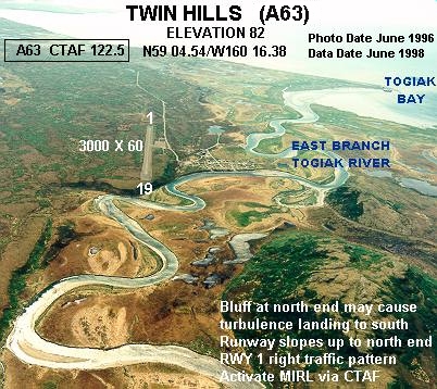
Runway 01/19
|
Dimension: |
3000 x 60 ft / 914.4 x 18.3 m |
|
Surface: |
GRAVEL, Fair Condition |
|
Edge
Lights: |
Medium |
|
|
Runway 01 |
Runway 19 |
|
Traffic
Pattern: |
Right |
Left |
|
Radio Navigation
Aids
|
ID |
Type |
Name |
Ch |
Freq |
Var |
Dist |
|
TOG |
NDB/DME |
Togiak |
114X |
393.00 |
19E |
3.2 nm |
Remarks
- BLUFF
AT NORTH END MAY CAUSE SOME TURBULENCE WHEN LNDG TO THE SOUTH.
- CAUTION:
RY COND NOT MNTRD; RCMD VISUAL INSPECTION PRIOR TO USE.
- PILOTS
ARE REQUESTED TO SELF-ANNOUNCE ON CTAF PRIOR TO TAXIING ON RWY FOR DEPARTURE;
LEAVING THE RWY AND WITHIN 10 NM OF THE ARPT WHEN APPROACHING TO LAND.
Operational Statistics
|
Aircraft
Operations: |
35/Week |
|
Air Taxi: |
84.7% |
|
General
Aviation Local: |
1.1% |
|
General
Aviation Itinerant: |
14.1% |
Twin Hills Airport
Address:
Bethel County, AK
Tel:
907-269-0767
Images
and information placed above are from
http://www.airport-data.com/airport/A63/
We
thank them for the data!
| General
Info |
| Country |
United
States |
| State |
ALASKA
|
| FAA ID |
A63
|
| Latitude |
59-04-32.238N
|
| Longitude |
160-16-22.957W
|
| Elevation |
82 feet
|
| Near City |
TWIN HILLS
|
We don't guarantee the information is fresh and accurate. The data may
be wrong or outdated.
For more up-to-date information please refer to other sources.
|
|


