 |
|
| Tununak Airport |
 |
| IATA: TNK – ICAO: none – FAA LID: 4KA |
| Summary |
| Airport type |
Public |
| Owner |
State of Alaska DOT&PF - Central Region |
| Serves |
Tununak, Alaska |
| Elevation AMSL |
14 ft / 4 m |
| Coordinates |
60°34′32″N 165°16′18″W / 60.57556°N 165.27167°W / 60.57556; -165.27167 |
| Runways |
| Direction |
Length |
Surface |
| ft |
m |
| 8/26 |
1,778 |
542 |
Gravel |
| Statistics |
| Enplanements (2008) |
1,809 |
| Source: Federal Aviation Administration |
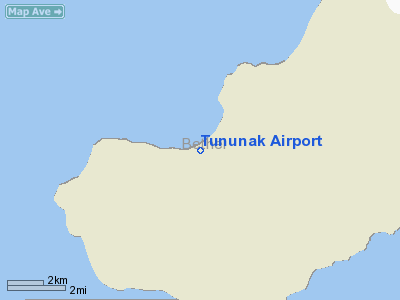
Tununak Airport (IATA: TNK, FAA LID: 4KA) is a state-owned, public-use airport located one nautical mile (1.85 km) southwest of the central business district of Tununak, in the Bethel Census Area of the U.S. state of Alaska.
As per Federal Aviation Administration records, this airport had 1,809 commercial passenger boardings (enplanements) in calendar year 2008, a decrease of 9.6% from the 2,001 enplanements in 2007. Tununak Airport is included in the FAA's National Plan of Integrated Airport Systems (2009-2013), which categorizes it as a general aviation facility.
Although most U.S. airports use the same three-letter location identifier for the FAA and IATA, this airport is assigned 4KA by the FAA and TNK by the IATA.
Facilities
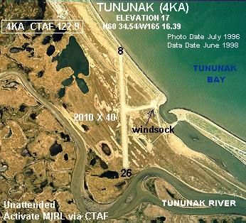
Tununak Airport has one runway designated 8/26 with a gravel surface measuring 1,778 by 30 feet (542 x 9 m). The airport is unattended.
Remarks:
- Surface has dips, soft spots, rocks 4-8 inches length of runway.
- 08/26 reflective markers on runway edge.
- Activate MIRL runway 08/26 - CTAF.
- Caution: runway condition not monitored; recommend visual inspection prior to using.
- Road 600' long used for landings and takeoff during strong crosswinds.
- Pilots are requested to self-announce on CTAF prior to taxiing on runway for departure; leaving the runway and within 10 NM of the airport when approaching to land.
- Windsock unreliable.
The above content comes from Wikipedia and is published under free licenses – click here to read more.
Location
& QuickFacts
|
FAA Information Effective: |
2006-06-08 |
|
Airport Identifier: |
4KA |
|
Longitude/Latitude: |
165-16-17.9340W/60-34-31.9690N
-165.271648/60.575547 (Estimated) |
|
Elevation: |
14 ft / 4.27 m (Surveyed) |
|
Land: |
0 acres |
|
From nearest city: |
1 nautical miles SW of Tununak, AK |
|
Location: |
Bethel County, AK |
|
Magnetic Variation: |
16E (1985) |
Owner
& Manager
|
Ownership: |
Publicly owned |
|
Owner: |
State Of Ak Dot/pf Cent Reg |
|
Address: |
Po Box 196900
Anchorage, AK 99519-6900 |
|
Phone number: |
907-269-0747 |
|
Manager: |
L.j. Davis |
|
Address: |
Po Box 505
Bethel, AK 99559 |
|
Phone number: |
907-543-2495 |
Airport
Operations and Facilities
|
Airport
Use: |
Open to public |
|
Wind
indicator: |
Yes
WINDSOCK MAY NOT BE RELIABLE. |
|
Segmented
Circle: |
No |
|
Control
Tower: |
No |
|
Attendance
Schedule: |
UNATNDD |
|
Lighting
Schedule: |
DUSK-DAWN
ACTVT MIRL RY 08/26 - CTAF. |
|
Beacon
Color: |
Clear-Green (lighted land airport) |
|
Landing
fee charge: |
No |
|
Sectional
chart: |
Bethel |
|
Region: |
AAL - Alaska |
|
Boundary
ARTCC: |
ZAN - Anchorage |
|
Tie-in
FSS: |
ENA - Kenai |
|
FSS
on Airport: |
No |
|
FSS
Phone: |
800-478-3576 |
|
FSS
Toll Free: |
1-800-WX-BRIEF |
|
NOTAMs
Facility: |
MYU (NOTAM-d service avaliable) |
|
Federal Agreements: |
N |
Airport
Communications
Airport
Services
|
Airframe
Repair: |
NONE |
|
Power
Plant Repair: |
NONE |
|
Bottled
Oxygen: |
NONE |
|
Bulk
Oxygen: |
NONE |
|
Runway Information
Runway 08/26
|
Dimension: |
2010 x 40 ft / 612.6 x 12.2 m |
|
Surface: |
GRVL, Poor Condition
SURFACE HAS DIPS, SOFT SPOTS,ROCKS 4-8 INCHES LENGTH OF RY. |
|
Edge
Lights: |
Medium |
|
|
Runway 08 |
Runway 26 |
|
Longitude: |
165-16-35.4180W |
165-16-00.4500W |
|
Latitude: |
60-34-33.6000N |
60-34-30.3380N |
|
Elevation: |
14.00 ft |
11.00 ft |
|
Alignment: |
101 |
127 |
|
Traffic
Pattern: |
Left |
Left |
|
Radio Navigation
Aids
|
ID |
Type |
Name |
Ch |
Freq |
Var |
Dist |
|
AIX |
NDB/DME |
Nanwak |
076X |
323.00 |
16E |
30.2 nm |
Remarks
- CAUTION:
RWY CONDITION NOT MONITORED; RECOMMEND VISUAL INSPECTION PRIOR TO USING.
- ROAD
600' LONG USED FOR LNDGS AND TKOF DURING STRONG CROSSWINDS.
- PILOTS
ARE REQUESTED TO SELF-ANNOUNCE ON CTAF PRIOR TO TAXIING ON RWY FOR DEPARTURE;
LEAVING THE RWY AND WITHIN 10 NM OF THE ARPT WHEN APPROACHING TO LAND.
Tununak Airport
Address:
Bethel County, AK
Tel:
907-269-0747, 907-543-2495
Images
and information placed above are from
http://www.airport-data.com/airport/4KA/
We
thank them for the data!
| General
Info |
| Country |
United
States |
| State |
ALASKA
|
| FAA ID |
4KA
|
| Latitude |
60-34-32.148N
|
| Longitude |
165-16-23.258W
|
| Elevation |
17 feet
|
| Near City |
TUNUNAK
|
We don't guarantee the information is fresh and accurate. The data may
be wrong or outdated.
For more up-to-date information please refer to other sources.
|
|


