 |
|
| Tuntutuliak Airport |
| IATA: WTL – ICAO: none – FAA LID: A61 |
| Summary |
| Airport type |
Public |
| Owner |
Alaska DOT&PF - Central Region |
| Serves |
Tuntutuliak, Alaska |
| Elevation AMSL |
16 ft / 5 m |
| Coordinates |
60°20′07″N 162°40′01″W / 60.33528°N 162.66694°W / 60.33528; -162.66694 |
| Runways |
| Direction |
Length |
Surface |
| ft |
m |
| 2/20 |
3,025 |
922 |
Gravel |
| Statistics (2008) |
| Aircraft operations |
390 |
| Source: Federal Aviation Administration |
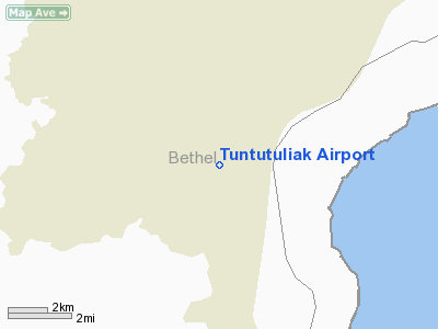
Tuntutuliak Airport (IATA: WTL, FAA LID: A61) is a state-owned public-use airport located one nautical mile (1.85 km) south of the central business district of Tuntutuliak, in the Bethel Census Area of the U.S. state of Alaska. Facilities and aircraft
Tuntutuliak Airport has one runway designated 2/20 with a gravel surface measuring 3,025 by 23 feet (922 x 7 m). For the 12-month period ending August 26, 2008, the airport had 390 aircraft operations, an average of 32 per month: 87% air taxi and 13% general aviation.
Airlines
- Hageland Aviation Services
The above content comes from Wikipedia and is published under free licenses – click here to read more.
Location
& QuickFacts
|
FAA
Information Effective: |
2006-06-08 |
|
Airport
Identifier: |
A61 |
|
Longitude/Latitude: |
162-40-01.2340W/60-20-07.2440N
-162.667009/60.335346 (Estimated) |
|
Elevation: |
16 ft / 4.88 m (Estimated) |
|
Land: |
0 acres |
|
From
nearest city: |
1 nautical miles S of Tuntutuliak, AK |
|
Location: |
Bethel County, AK |
|
Magnetic Variation: |
18E (1985) |
Owner
& Manager
|
Ownership: |
Publicly owned |
|
Owner: |
State Of Alaska Dot/pf C Reg |
|
Address: |
Po Box 196900
Anchorage, AK 99519-6900 |
|
Phone number: |
907-266-1767 |
|
Manager: |
L.j. Davis |
|
Address: |
Po Box 505
Bethel, AK 99559 |
|
Phone number: |
907 543-2495 |
Airport
Operations and Facilities
|
Airport
Use: |
Open to public |
|
Wind
indicator: |
Yes
WIND SOCK LGTS INOP. |
|
Segmented
Circle: |
Yes |
|
Control
Tower: |
No |
|
Attendance
Schedule: |
UNATNDD |
|
Lighting
Schedule: |
DUSK-DAWN
ACTVT MIRL RY 02/20 - 122.900. |
|
Beacon
Color: |
Clear (unlighted land airport) |
|
Landing
fee charge: |
No |
|
Sectional
chart: |
Bethel |
|
Region: |
AAL - Alaska |
|
Boundary
ARTCC: |
ZAN - Anchorage |
|
Tie-in
FSS: |
ENA - Kenai |
|
FSS
on Airport: |
No |
|
FSS
Phone: |
800-478-3576 |
|
FSS
Toll Free: |
1-800-WX-BRIEF |
|
NOTAMs
Facility: |
BET (NOTAM-d service avaliable) |
|
Federal Agreements: |
NGY |
Airport
Communications
Airport
Services
|
Airframe
Repair: |
NONE |
|
Power
Plant Repair: |
NONE |
|
Runway Information
Runway 03/21
|
Dimension: |
1772
x 23 ft / 540.1 x 7.0 m
RY 02/20 REMEASURED. |
|
Surface: |
GRVL, Poor Condition
DIPS & RUTS TO 4 INCHES DEEP. |
|
Edge
Lights: |
Medium
RY & TWY LIGHTS ARE HIGHER THAN STANDARD INTST. |
|
|
Runway 03 |
Runway 21 |
|
Traffic
Pattern: |
Left |
Left |
|
Obstruction: |
, 50:1 slope to clear |
26 ft trees, 750.0 ft from runway, 28:1 slope
to clear |
|
Radio Navigation
Aids
|
ID |
Type |
Name |
Ch |
Freq |
Var |
Dist |
|
OSE |
NDB |
Oscarville |
|
251.00 |
19E |
36.1 nm |
|
ET |
NDB |
Bethel |
|
344.00 |
19E |
37.3 nm |
|
IIK |
VOR/DME |
Kipnuk |
106X |
115.90 |
17E |
47.2 nm |
|
BET |
VORTAC |
Bethel |
088X |
114.10 |
19E |
36.7 nm |
Remarks
- NORTH
END SAFETY AREA 70 FT FROM RIVER BLUFF EDGE; RY 02 SAFETY AREA 20 FT
FROM RIVER EDGE.
- CTN:
RWY CONDITION NOT MONITORED; RECOMMEND VISUAL INSPECTION PRIOR TO USE.
- RY
AND RAMP SOFT DURING BREAKUP AND HEAVY RAINS.
- BECAUSE
OF FROST HEAVES RY & TWY LGTS ARE 36 INCHES HIGH.
- PILOTS
ARE REQUESTED TO SELF-ANNOUNCE ON CTAF PRIOR TO TAXIING ON RWY FOR DEPARTURE;
LEAVING THE RWY AND WITHIN 10 NM OF THE ARPT WHEN APPROACHING TO LAND.
Based Aircraft
|
Aircraft
based on field: |
1 |
|
Single
Engine Airplanes: |
1 |
Tuntutuliak Airport
Address:
Bethel County, AK
Tel:
907-266-1767, 907 543-2495
Images
and information placed above are from
http://www.airport-data.com/airport/A61/
We
thank them for the data!
| General
Info |
| Country |
United
States |
| State |
ALASKA
|
| FAA ID |
A61
|
| Latitude |
60-20-07.244N
|
| Longitude |
162-40-01.234W
|
| Elevation |
16 feet
|
| Near City |
TUNTUTULIAK
|
We don't guarantee the information is fresh and accurate. The data may
be wrong or outdated.
For more up-to-date information please refer to other sources.
|
|


