 |
|
| Tokeen Seaplane Base |
 |
| IATA: TKI – ICAO: none – FAA LID: 57A |
| Summary |
| Airport type |
Public |
| Owner |
Public Domain |
| Serves |
Tokeen, Alaska |
| Elevation AMSL |
0 ft / 0 m |
| Coordinates |
55°56′14″N 133°19′36″W / 55.93722°N 133.32667°W / 55.93722; -133.32667 |
| Runways |
| Direction |
Length |
Surface |
| ft |
m |
| NE/SW |
6,000 |
1,829 |
Water |
| Statistics (2006) |
| Aircraft operations |
55 |
| Source: Federal Aviation Administration |
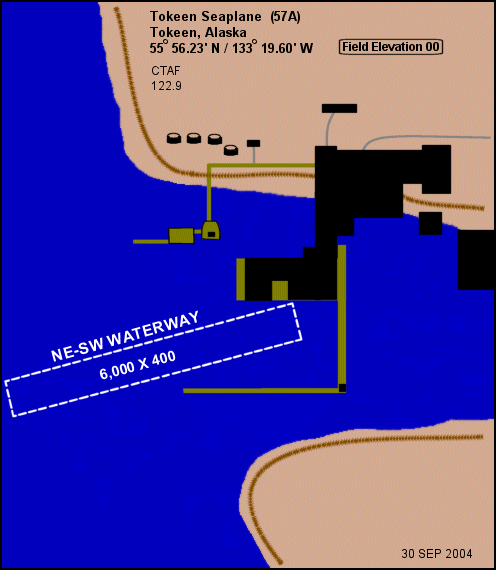
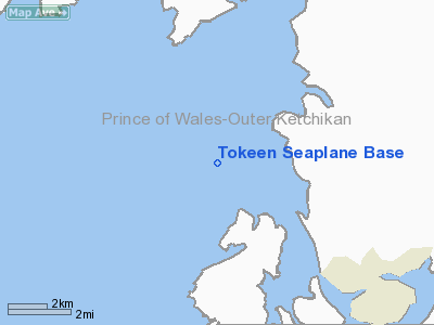
Tokeen Seaplane Base (IATA: TKI, FAA LID: 57A) is a public use seaplane base located in Tokeen, in the Prince of Wales-Hyder Census Area in the U.S. state of Alaska.
Facilities and aircraft
Tokeen Seaplane Base has one seaplane landing area designated NE/SW which measures 6,000 by 400 feet (1,829 x 122 m). For the 12-month period ending December 31, 2006, the airport had 55 aircraft operations, an average of 4 per month: 91% air taxi and 9% general aviation.
The above content comes from Wikipedia and is published under free licenses – click here to read more.
Location
& QuickFacts
|
FAA
Information Effective: |
2006-02-16 |
|
Airport
Identifier: |
57A |
|
Longitude/Latitude: |
133-19-36.1970W/55-56-13.6800N
-133.326721/55.937133 (Estimated) |
|
Elevation: |
0 ft / 0.00 m (Estimated) |
|
Land: |
0 acres |
|
From
nearest city: |
0 nautical miles W of Tokeen, AK |
|
Location: |
Prince Of Wales County, AK |
|
Magnetic Variation: |
26E (1985) |
Owner
& Manager
|
Ownership: |
Privately owned |
|
Owner: |
Public Domain |
|
Address: |
|
|
Address: |
|
Airport
Operations and Facilities
|
Airport
Use: |
Open to public |
|
Wind
indicator: |
No |
|
Segmented
Circle: |
No |
|
Control
Tower: |
No |
|
Attendance
Schedule: |
UNATNDD |
|
Landing
fee charge: |
No |
|
Sectional
chart: |
Ketchikan |
|
Region: |
AAL - Alaska |
|
Boundary
ARTCC: |
ZAN - Anchorage |
|
Tie-in
FSS: |
KTN - Ketchikan |
|
FSS
on Airport: |
No |
|
FSS
Phone: |
907-225-9481 |
|
FSS
Toll Free: |
LC225-9481 |
|
NOTAMs
Facility: |
KTN (NOTAM-d service avaliable) |
Airport
Communications
Airport
Services
|
Airframe
Repair: |
NONE |
|
Power
Plant Repair: |
NONE |
|
Bottled
Oxygen: |
NONE |
|
Bulk
Oxygen: |
NONE |
|
Runway
Information
Runway NE/SW
|
Dimension: |
6000 x 400 ft / 1828.8 x 121.9 m |
|
Surface: |
WATER, |
|
|
Runway NE |
Runway SW |
|
Traffic
Pattern: |
Left |
Left |
|
Markings: |
None, |
None, |
|
Runway
End Identifier: |
No |
No |
|
Centerline
Lights: |
No |
No |
|
Touchdown
Lights: |
No |
No |
|
Radio Navigation
Aids
|
ID |
Type |
Name |
Ch |
Freq |
Var |
Dist |
|
SQM |
NDB |
Sumner Strait |
|
529.00 |
28E |
32.6 nm |
|
AKW |
NDB/DME |
Klawock |
105X |
229.00 |
24E |
23.7 nm |
|
LVD |
VOR/DME |
Level Island |
112X |
116.50 |
28E |
32.9 nm |
Remarks
- BOATS
ACTV IN HARBOR VCNTY; NO FLOAT ACFT USE BEACH.
Operational Statistics
|
Aircraft
Operations: |
13/Month |
|
Air Taxi: |
66.7% |
|
General
Aviation Itinerant: |
33.3% |
Tokeen Seaplane Base
Address:
Prince Of Wales County, AK
Tel:
Images
and information placed above are from
http://www.airport-data.com/airport/57A/
We
thank them for the data!
| General
Info |
| Country |
United
States |
| State |
ALASKA
|
| FAA ID |
57A
|
| Latitude |
55-56-13.680N
|
| Longitude |
133-19-36.197W
|
| Elevation |
0 feet
|
| Near City |
TOKEEN
|
We don't guarantee the information is fresh and accurate. The data may
be wrong or outdated.
For more up-to-date information please refer to other sources.
|
|


