|
|
| Tok Airport |
 |
| IATA: TKJ – ICAO: PATJ – FAA LID: TKJ |
| Summary |
| Airport type |
Public |
| Owner |
Alaska DOT&PF - Northern Region |
| Serves |
Tok, Alaska |
| Elevation AMSL |
1,670 ft / 509 m |
| Coordinates |
63°18′12″N 143°00′04″W / 63.30333°N 143.00111°W / 63.30333; -143.00111 (Tok Airport) |
| Runways |
| Direction |
Length |
Surface |
| ft |
m |
| 13/31 |
1,690 |
515 |
Gravel/Turf |
| Statistics (2005) |
| Aircraft operations |
600 |
| Based aircraft |
17 |
| Source: Federal Aviation Administration |
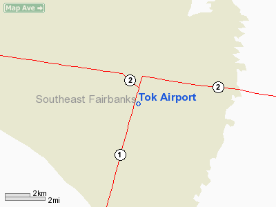
Tok Airport (IATA: TKJ, ICAO: PATJ, FAA LID: TKJ) is a state-owned public-use airport located two nautical miles (3.7 km) south of the central business district of Tok, in the Southeast Fairbanks Census Area of the U.S. state of Alaska. Facilities and aircraft
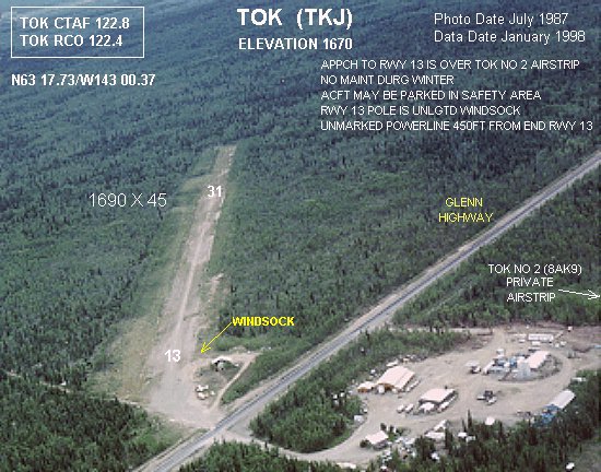
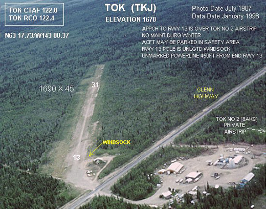
Tok Airport has one runway designated 13/31 with a 1,690 by 45 ft (515 x 14 m) gravel and turf surface. For the 12-month period ending December 31, 2005, the airport had 600 aircraft operations, an average of 50 per month: 83% general aviation and 17% air taxi. At that time there were 17 aircraft based at this airport, all single-engine.
Other airports in Tok
Tok Junction Airport (ICAO: PFTO, FAA LID: 6K8) is state-owned public-use located at 63°19′46″N 142°57′13″W / 63.32944°N 142.95361°W / 63.32944; -142.95361 (Tok Junction Airport), one nautical mile (1.85 km) east of the central business district of Tok. It has one runway designated 7/25 with a 2,509 x 50 ft (765 x 15 m) asphalt surface.
Tok 2 Airport (FAA LID: 8AK9) is a private-use airport located at 63°18′32″N 143°01′04″W / 63.30889°N 143.01778°W / 63.30889; -143.01778 (Tok 2 Airport), on the opposite side of Glenn Highway from the Tok Airport. It has one runway designated 10/28 with a 2,035 x 80 ft (620 x 24 m) gravel surface.
The above content comes from Wikipedia and is published under free licenses – click here to read more.
Location
& QuickFacts
|
FAA
Information Effective: |
2006-02-16 |
|
Airport
Identifier: |
TKJ |
|
Longitude/Latitude: |
143-00-22.0220W/63-17-43.7400N
-143.006117/63.295483 (Estimated) |
|
Elevation: |
1670 ft / 509.02 m (Surveyed) |
|
Land: |
0 acres |
|
From
nearest city: |
2 nautical miles S of Tok, AK |
|
Location: |
Fairbanks County, AK |
|
Magnetic Variation: |
29E (1985) |
Owner
& Manager
|
Ownership: |
Publicly owned |
|
Owner: |
St Of Ak Dotpf/n Rgn |
|
Address: |
2301 Peger Rd
Fairbanks, AK 99709 |
|
Phone number: |
907-451-2294 |
|
Manager: |
James Fehrenbachetr |
|
Address: |
Po Box 356
Tok, AK 99787 |
|
Phone number: |
907-883-5128 |
Airport
Operations and Facilities
|
Airport
Use: |
Open to public |
|
Wind
indicator: |
Yes |
|
Segmented
Circle: |
Yes |
|
Control
Tower: |
No |
|
Attendance
Schedule: |
UNATNDD |
|
Landing
fee charge: |
No |
|
Sectional
chart: |
Anchorage |
|
Region: |
AAL - Alaska |
|
Boundary
ARTCC: |
ZAN - Anchorage |
|
Tie-in
FSS: |
ORT - Northway |
|
FSS
on Airport: |
No |
|
FSS
Phone: |
907-778-2219 |
|
FSS
Toll Free: |
1-478-6611 |
|
Alternate
FSS: |
FAI - Fairbanks |
|
Alt.
FSS Toll Free: |
1-866-248-6516 |
|
NOTAMs
Facility: |
ORT (NOTAM-d service avaliable) |
Airport
Communications
Airport
Services
|
Airframe
Repair: |
NONE |
|
Power
Plant Repair: |
NONE |
|
Bottled
Oxygen: |
NONE |
|
Bulk
Oxygen: |
NONE |
|
Runway Information
Runway 13/31
|
Dimension: |
1690 x 45 ft / 515.1 x 13.7 m |
|
Surface: |
GRVL-TURF, Fair Condition |
|
|
Runway 13 |
Runway 31 |
|
Traffic
Pattern: |
Left |
Left |
|
Markings: |
None, |
None, |
|
Runway
End Identifier: |
No |
No |
|
Centerline
Lights: |
No |
No |
|
Touchdown
Lights: |
No |
No |
|
Obstruction: |
40 ft pole, 280.0 ft from runway, 115 ft right
of centerline, 7:1 slope to clear |
30 ft trees, 600.0 ft from runway, 20:1 slope
to clear |
|
Radio Navigation
Aids
|
ID |
Type |
Name |
Ch |
Freq |
Var |
Dist |
|
AES |
NDB |
Nabesna |
|
390.00 |
30E |
36.3 nm |
|
ORT |
VORTAC |
Northway |
110X |
116.30 |
30E |
36.3 nm |
Remarks
- 70
FT WIDE SWATH CUT THROUGH TREES ON RY 31 APCH.
- APCH
TO RY 13 IS OVER TOK NR 2 (PRIVATE AIRSTRIP).
- RY
13/31 SAFETY AREA 2600 FT BY 60 FT. ACFT MAY BE PARKED IN SAFETY AREA
NEAR APCH END RY 13. BRUSH TO 10 FT ON BOTH SIDES OF SAFETY AREA.
- NO
MAINT IN WINTER.
- SUAIS
- 125.3(1-800-758-8723).
- KNOB
RIDGE WX CAMERA AVBL ON INTERNET AT HTTP://AKWEATHERCAMS.FAA.GOV
Based Aircraft
|
Aircraft
based on field: |
5 |
|
Single
Engine Airplanes: |
5 |
Operational Statistics
|
Aircraft
Operations: |
12/Week |
|
Air Taxi: |
16.7% |
|
General
Aviation Local: |
50.0% |
|
General
Aviation Itinerant: |
33.3% |
Tok Airport
Address:
Fairbanks County, AK
Tel:
907-451-2294, 907-883-5128
Images
and information placed above are from
http://www.airport-data.com/airport/TKJ/
We
thank them for the data!
| General
Info |
| Country |
United
States |
| State |
ALASKA
|
| FAA ID |
TKJ
|
| Latitude |
63-17-43.740N
|
| Longitude |
143-00-22.022W
|
| Elevation |
1670 feet
|
| Near City |
TOK
|
We don't guarantee the information is fresh and accurate. The data may
be wrong or outdated.
For more up-to-date information please refer to other sources.
|
|