 |
|
| Togiak Airport |
 |
| IATA: TOG – ICAO: PATG – FAA LID: TOG |
| Summary |
| Airport type |
Public |
| Owner |
State of Alaska DOT&PF - Central Region |
| Serves |
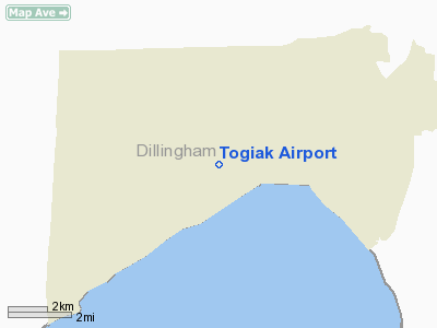
Togiak Village, Alaska |
| Elevation AMSL |
21 ft / 6 m |
| Coordinates |
59°03′13″N 160°23′49″W / 59.05361°N 160.39694°W / 59.05361; -160.39694 |
| Runways |
| Direction |
Length |
Surface |
| ft |
m |
| 3/21 |
4,400 |
1,341 |
Gravel |
| 10/28 |
981 |
299 |
Gravel |
| Statistics (2006) |
| Aircraft operations |
10,200 |
| Enplanements (2008) |
1,781 |
| Source: Federal Aviation Administration |
Togiak Airport (IATA: TOG, ICAO: PATG, FAA LID: TOG) is a state-owned, public-use airport located in Togiak Village, in the Bethel Census Area of the U.S. state of Alaska.
As per Federal Aviation Administration records, this airport had 1,781 commercial passenger boardings (enplanements) in calendar year 2008, a decrease of 6% from the 1,886 enplanements in 2007 and 43% from the 3,119 enplanements in 2006. Togiak Airport is included in the FAA's National Plan of Integrated Airport Systems (2009-2013) as commercial service - non-primary, a category for airports with 2,500 to 10,000 enplanements per year. Airlines and destinations
Facilities and aircraft
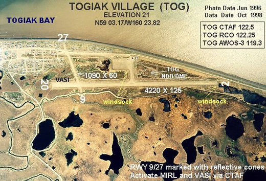
Togiak Airport has two runways with gravel surfaces: 3/21 measures 4,400 by 75 feet (1,341 x 23 m) and 10/28 is 981 by 59 feet (299 x 18 m). The airport is unattended. For the 12-month period ending December 31, 2006, the airport had 10,200 aircraft operations, an average of 27 per day: 78% air taxi and 22% general aviation.
Remarks:
- Runways 10 & 28 non-standard markings; runways edges not marked, thresholds marked with damaged & faded panels.
- Activate MIRL runway 03/21 & VASI runway 21 - CTAF.
- Segmented circle damaged & overgrown with vegetation.
- Runway condition not monitored, recommend visual inspection prior to use.
- When available weather reports hourly only.
The above content comes from Wikipedia and is published under free licenses – click here to read more.
Location
& QuickFacts
|
FAA
Information Effective: |
2006-02-16 |
|
Airport
Identifier: |
TOG |
|
Longitude/Latitude: |
160-23-48.9620W/59-03-10.2320N
-160.396934/59.052842 (Estimated) |
|
Elevation: |
21 ft / 6.40 m (Estimated) |
|
Land: |
0 acres |
|
From
nearest city: |
0 nautical miles SW of Togiak Village, AK |
|
Location: |
Bethel County, AK |
|
Magnetic Variation: |
15E (2005) |
Owner
& Manager
|
Ownership: |
Publicly owned |
|
Owner: |
State Of Ak Dotpf-central Rgn |
|
Address: |
Box 250
Anchorage, AK 99519-6900 |
|
Phone number: |
907-269-0767 |
|
Manager: |
Norman Heyano |
|
Address: |
Box 214
Dillingham, AK 99576 |
|
Phone number: |
907-842-5511 |
Airport
Operations and Facilities
|
Airport
Use: |
Open to public |
|
Wind
indicator: |
Yes |
|
Segmented
Circle: |
Yes |
|
Control
Tower: |
No |
|
Attendance
Schedule: |
UNATNDD |
|
Lighting
Schedule: |
DUSK-DAWN
ACTVT MIRL RY 03/21 & VASI RY 21 - CTAF. |
|
Beacon
Color: |
Clear-Green (lighted land airport) |
|
Landing
fee charge: |
No |
|
Sectional
chart: |
Kodiak |
|
Region: |
AAL - Alaska |
|
Boundary
ARTCC: |
ZAN - Anchorage |
|
Tie-in
FSS: |
ENA - Kenai |
|
FSS
on Airport: |
No |
|
FSS
Phone: |
800-478-3576 |
|
FSS
Toll Free: |
1-800-WX-BRIEF |
|
NOTAMs
Facility: |
TOG (NOTAM-d service avaliable) |
|
Federal Agreements: |
N |
Airport
Communications
Airport
Services
|
Airframe
Repair: |
NONE |
|
Power
Plant Repair: |
NONE |
|
Bottled
Oxygen: |
NONE |
|
Bulk
Oxygen: |
NONE |
|
Runway Information
Runway 03/21
|
Dimension: |
4400 x 98 ft / 1341.1 x 29.9 m |
|
Surface: |
GRVL, Good Condition |
|
Edge
Lights: |
Medium |
|
|
Runway 03 |
Runway 21 |
|
Traffic
Pattern: |
Left |
Left |
|
Crossing
Height: |
0.00 ft |
25.00 ft |
|
VASI: |
|
4-box on left side
VASI 3.00 DEG; DOWNWIND BAR 135 FT; UPWIND BAR 835 FT.
RRP
485 FT FROM THR; TCH 25 FT. |
|
Visual
Glide Angle: |
0.00� |
3.00� |
|
Runway 10/28
|
Dimension: |
1200 x 49 ft / 365.8 x 14.9 m |
|
Surface: |
GRVL, Good Condition |
|
|
Runway 10 |
Runway 28 |
|
Traffic
Pattern: |
Left |
Left |
|
Markings: |
None,
RY 10/28 MKD BY REFLECTIVE CONES. THLDS MKD BY REFLECTIVE
PANELS. |
None, |
|
Runway
End Identifier: |
No |
No |
|
Centerline
Lights: |
No |
No |
|
Touchdown
Lights: |
No |
No |
|
Obstruction: |
300 ft hill, 6000.0 ft from runway, 20:1 slope
to clear |
, 50:1 slope to clear |
|
Radio Navigation
Aids
|
ID |
Type |
Name |
Ch |
Freq |
Var |
Dist |
|
TOG |
NDB/DME |
Togiak |
114X |
393.00 |
19E |
1.0 nm |
Remarks
- CAUTION:
RY COND NOT MNTRD; RCMD VISUAL INSPECTION PRIOR TO USE.
- WHEN
AVBL WX REPORTS HOURLY ONLY.
- PILOTS
ARE REQUESTED TO SELF-ANNOUNCE ON CTAF PRIOR TO TAXIING ON RWY FOR DEPARTURE;
LEAVING THE RWY AND WITHIN 10 NM OF THE ARPT WHEN APPROACHING TO LAND.
Based Aircraft
|
Aircraft
based on field: |
8 |
|
Single
Engine Airplanes: |
8 |
Operational Statistics
|
Aircraft
Operations: |
197/Week |
|
Air Taxi: |
78.4% |
|
General
Aviation Local: |
19.6% |
|
General
Aviation Itinerant: |
2.0% |
Togiak Airport
Address:
Bethel County, AK
Tel:
907-269-0767, 907-842-5511
Images
and information placed above are from
http://www.airport-data.com/airport/TOG/
We
thank them for the data!
| General
Info |
| Country |
United
States |
| State |
ALASKA
|
| FAA ID |
TOG
|
| Latitude |
59-03-10.232N
|
| Longitude |
160-23-48.962W
|
| Elevation |
21 feet
|
| Near City |
TOGIAK
VILLAGE |
We don't guarantee the information is fresh and accurate. The data may
be wrong or outdated.
For more up-to-date information please refer to other sources.
|
|


