 |
|
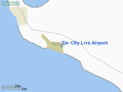
| Tin City LRRS Airport |
| IATA: TNC – ICAO: PATC – FAA LID: TNC |
| Summary |
| Airport type |
Military |
| Owner |
U.S. Air Force |
| Location |
Tin City, Alaska |
| Elevation AMSL |
269 ft / 82 m |
| Coordinates |
65°33′47″N 167°55′18″W / 65.56306°N 167.92167°W / 65.56306; -167.92167 |
| Runways |
| Direction |
Length |
Surface |
| ft |
m |
| 16/34 |
4,700 |
1,433 |
Gravel |
| Statistics (1980) |
| Aircraft operations |
350 |
| Source: Federal Aviation Administration |
Tin City LRRS Airport (IATA: TNC, ICAO: PATC, FAA LID: TNC) is a military airport located one nautical mile (1.85 km) east of the central business district of Tin City, in the Nome Census Area of the U.S. state of Alaska. It is owned by the U.S. Air Force. It is also known as Tin City Airport. This airstrip supported the Tin City LRRS, an acronym for Long Range Radar Site or Long Range Radar Station. Facilities and aircraft
Tin City LRRS Airport has one runway designated 16/34 with a gravel surface measuring 4,700 by 100 feet (1,433 x 30 m). For the 12-month period ending July 9, 1980, the airport had 350 aircraft operations: 57% air taxi, 29% general aviation and 14% military.
Airlines and destinations
The above content comes from Wikipedia and is published under free licenses – click here to read more.
Location
& QuickFacts
|
FAA
Information Effective: |
2006-02-16 |
|
Airport
Identifier: |
TNC |
|
Longitude/Latitude: |
167-55-17.9640W/65-33-47.1850N
-167.921657/65.563107 (Estimated) |
|
Elevation: |
269 ft / 81.99 m (Surveyed) |
|
Land: |
0 acres |
|
From
nearest city: |
1 nautical miles E of Tin City, AK |
|
Location: |
Nome County, AK |
|
Magnetic Variation: |
13E (2005) |
Owner
& Manager
|
Ownership: |
Army owned |
|
Owner: |
Us Air Force, Suite 102 |
|
Address: |
11 Acw 6900 9th St Suite 301
Elmendorf Afb, AK 99506-2270 |
|
Manager: |
Major William Newton, Ste 102 |
|
Address: |
11 Acw 6900 9th St Suite 301
Elmendorf Afb, AK 99506-2270 |
|
Phone number: |
907-552-4747 |
Airport
Operations and Facilities
|
Airport
Use: |
Private
CLOSED TO THE PUBLIC. OFFICIAL BUSINESS ONLY. |
|
Wind
indicator: |
Yes |
|
Segmented
Circle: |
No |
|
Control
Tower: |
No |
|
Attendance
Schedule: |
ALL/ALL/DALGT |
|
Landing
fee charge: |
Yes |
|
Sectional
chart: |
Nome |
|
Region: |
AAL - Alaska |
|
Boundary
ARTCC: |
ZAN - Anchorage |
|
Tie-in
FSS: |
OME - Nome |
|
FSS
on Airport: |
No |
|
FSS
Phone: |
LC 443-2291 |
|
FSS
Toll Free: |
1-800-478-8400 |
|
Alternate
FSS: |
FAI - Fairbanks |
|
Alt.
FSS Toll Free: |
1-866-248-6516 |
|
NOTAMs
Facility: |
OME (NOTAM-d service avaliable) |
Airport
Communications
Airport
Services
|
Airframe
Repair: |
NONE |
|
Power
Plant Repair: |
NONE |
|
Bottled
Oxygen: |
NONE |
|
Bulk
Oxygen: |
NONE |
|
Runway Information
Runway 16/34
|
Dimension: |
4700 x 135 ft / 1432.6 x 41.1 m |
|
Surface: |
GRVL, |
|
|
Runway 16 |
Runway 34 |
|
Elevation: |
253.00 ft |
240.00 ft |
|
Traffic
Pattern: |
Left |
Left |
|
VASI: |
2-box on left side |
2-box on left side |
|
Runway
End Identifier: |
Yes |
Yes |
|
Centerline
Lights: |
No |
No |
|
Touchdown
Lights: |
No |
No |
|
Remarks
- TURBC
ON APPROACH. RADOME WINDS NOT ALWAYS AVBL.
- CAUTION;
SFC WNDS FM 260 THRU 310 DEGS IN EXCESS OF 15 KTS MAY PRODUCE SEVERE
TURBULANCE.
- AFTER
INITIAL RADIO CONTACT ON FREQ 126.2 OR 121.5 EXPECT A 30 MIN DELAY FOR
CURRENT AIRSTRIP CONDITION.
- FLD
ON HIGH BLUFF; RWY CENTER HIGHER THAN BOTH ENDS NO LINE OF SIGHT.
- DAYLIGHT
OPNS ONLY.
- USAF
INSTALLATION, ALL CIVIL ACFT OPERS REQ CIVIL ACFT LNDG PERMITS PRIOR
TO LANDING AT FACILITY. FINES WILL BE LEVIED AGAINST VIOLATORS &
REPORTS WILL BE FWDD TO FAA FSDOS IAW 32CFR855 & USAF OPERG INSTRGS.
OPERS MUST HAVE ON BOARD A COPY OF CURRENT PERMIT. FOR
PERMITS CALL 907-552-7384/3636/5265.
- BE
ALERT; INCRD THREAT TO ACFT BY THE POSSIBLE PRESENCE OF LARGE NRS OF
'SANDHILL CRANES' IN THE AREA OF THE ARPT DURING MID MAY. THESE CRANES
ARE QUITE LARGE (3 FT LONG WITH 6 1/2 FT WINGSPAN) AND SLOW FLYING.
THEY FLY AND GRAZE IN LARGE FLOCKS.
- THE
INCRD RISK IS IN ADDITION TO THE BIRD ACTIVITIES IN THE RISK ANALYSIS
OF WILDLIFE HAZARDS TO ACFT AT TIN CITY ARPT. DILIGENCE
BY ALL PERSONNEL IS RECOMMENDED THROUGHOUT THE SEASON.
- ALL
MIL, GOVT AND CIV ACFT OPERATORS SHALL OBTAIN A PPR CTL NR A MIN OF
1-HR PRIOR TO DEP FOR SITE, REQUEST NO EARLIER THAN DAY OF PLANNED TRAVEL,
CTC SITE PERSONNEL AT: DSN 317-552-9403/9283 C907-552-9403/9283.
AFLD IS CLSD
WEEKENDS AND ALL FEDERAL HOL.
- PASSENGERS
MUST COORDINATE ALL TRAVEL WITH ARS PROGRAM MANAGEMENT (DSN 317-552-4400/1989
OR C907-552-4400/1989) ON ALL NON-EMERGENCY TRAVEL TO SITE.
Operational Statistics
|
Aircraft
Operations: |
30/Month |
|
Air Taxi: |
57.1% |
|
General
Aviation Itinerant: |
28.6% |
|
Military: |
14.3% |
Tin City Lrrs Airport
Address:
Nome County, AK
Tel:
907-552-4747
Images
and information placed above are from
http://www.airport-data.com/airport/TNC/
We
thank them for the data!
| General
Info |
| Country |
United
States |
| State |
ALASKA
|
| FAA ID |
TNC
|
| Latitude |
65-33-47.185N
|
| Longitude |
167-55-17.964W
|
| Elevation |
269 feet
|
| Near City |
TIN CITY
|
We don't guarantee the information is fresh and accurate. The data may
be wrong or outdated.
For more up-to-date information please refer to other sources.
|
|


