|
|
| Tenakee Seaplane Base |
 |
| IATA: TKE – ICAO: none – FAA LID: TKE |
| Summary |
| Airport type |
Public |
| Owner |
State of Alaska DOT&PF - Southeast Region |
| Serves |
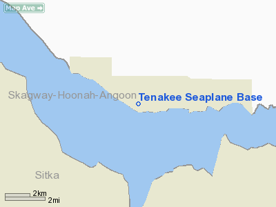
Tenakee Springs, Alaska |
| Elevation AMSL |
0 ft / 0 m |
| Coordinates |
57°46′47″N 135°13′06″W / 57.77972°N 135.21833°W / 57.77972; -135.21833 (Tenakee Seaplane Base) |
| Runways |
| Direction |
Length |
Surface |
| ft |
m |
| E/W |
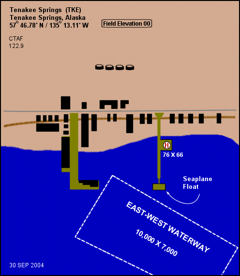
10,000 |
3,048 |
Water |
| Helipads |
| Number |
Length |
Surface |
| ft |
m |
| H1 |
76 |
23 |
Wood |
| Statistics |
| Aircraft operations (2006) |
650 |
| Enplanements (2008) |
635 |
| Sources: Federal Aviation Administration |
Tenakee Seaplane Base (IATA: TKE, FAA LID: TKE) is a state-owned public-use seaplane base located in Tenakee Springs, a city on Chichagof Island in the Hoonah-Angoon Census Area of the U.S. state of Alaska. Airline service is subsidized by the Essential Air Service program.
As per Federal Aviation Administration records, the airport had 635 passenger boardings (enplanements) in calendar year 2008, a decrease of 8.8% from the 696 enplanements in 2007. It is included in the FAA's National Plan of Integrated Airport Systems for 2009–2013, which categorizes it as a general aviation facility. Facilities and aircraft
Tenakee Seaplane Base has a seaplane landing area designated E/W which measures 10,000 by 7,000 feet (3,048 x 2,134 m). It also has a helipad designated H1 with a wood surface measuring 76 by 66 feet (23 x 20 m). For the 12-month period ending December 31, 2006, it had 650 aircraft operations, an average of 54 per month: 77% air taxi and 23% general aviation.
Airline and destination
- Alaska Seaplane Service (Juneau)
The above content comes from Wikipedia and is published under free licenses – click here to read more.
Location
& QuickFacts
|
FAA
Information Effective: |
2006-02-16 |
|
Airport
Identifier: |
TKE |
|
Longitude/Latitude: |
135-13-06.3980W/57-46-46.7700N
-135.218444/57.779658 (Estimated) |
|
Elevation: |
0 ft / 0.00 m (Estimated) |
|
Land: |
0 acres |
|
From
nearest city: |
0 nautical miles N of Tenakee Springs, AK |
|
Location: |
Sitka County, AK |
|
Magnetic Variation: |
27E (1985) |
Owner
& Manager
|
Ownership: |
Publicly owned |
|
Owner: |
City Of Tenakee |
|
Address: |
Po Box 52
Tenakee, AK |
|
Phone number: |
907-736-2207 |
|
Manager: |
Channel Flying Svs |
|
Address: |
Tenakee Springs, AK 99841 |
Airport
Operations and Facilities
|
Airport
Use: |
Open to public |
|
Wind
indicator: |
Yes |
|
Segmented
Circle: |
No |
|
Control
Tower: |
No |
|
Attendance
Schedule: |
ALL/ALL/DALGT |
|
Landing
fee charge: |
No |
|
Sectional
chart: |
Juneau |
|
Region: |
AAL - Alaska |
|
Boundary
ARTCC: |
ZAN - Anchorage |
|
Tie-in
FSS: |
JNU - Juneau |
|
FSS
on Airport: |
No |
|
FSS
Phone: |
907-586-7380 |
|
FSS
Toll Free: |
1-800-WX-BRIEF |
|
NOTAMs
Facility: |
JNU (NOTAM-d service avaliable) |
|
Federal Agreements: |
NY1 |
Airport
Communications
Airport
Services
|
Fuel
available: |
100 80
FUEL AVBL IN EMERG ONLY. |
|
Airframe
Repair: |
NONE |
|
Power
Plant Repair: |
NONE |
|
Bottled
Oxygen: |
NONE |
|
Bulk
Oxygen: |
NONE |
|
Runway Information
Runway E/W
|
Dimension: |
10000 x 7000 ft / 3048.0 x 2133.6 m |
|
Surface: |
WATER, |
|
|
Runway E |
Runway W |
|
Traffic
Pattern: |
Left |
Left |
|
Markings: |
None, |
None, |
|
Runway
End Identifier: |
No |
No |
|
Centerline
Lights: |
No |
No |
|
Touchdown
Lights: |
No |
No |
|
Helipad H1
|
Dimension: |
76 x 66 ft / 23.2 x 20.1 m |
|
Surface: |
WOOD, |
|
|
Runway H1 |
Runway |
|
Traffic
Pattern: |
Left |
Left |
|
Radio Navigation
Aids
|
ID |
Type |
Name |
Ch |
Freq |
Var |
Dist |
|
JDL |
FAN MARKER |
Lynns |
|
|
29E |
35.1 nm |
|
EEF |
NDB |
Elephant |
|
391.00 |
29E |
23.6 nm |
|
CGL |
NDB |
Coghlan Island |
|
212.00 |
29E |
38.5 nm |
|
MND |
NDB |
Mendenhall |
|
332.00 |
29E |
39.5 nm |
|
GAV |
NDB |
Gustavus |
|
219.00 |
25E |
41.6 nm |
|
IME |
NDB |
Mount Edgecumbe |
|
414.00 |
28E |
44.3 nm |
|
SSR |
VORTAC |
Sisters Island |
087X |
114.00 |
29E |
24.0 nm |
|
JNU |
VOT |
Juneau |
|
111.00 |
|
42.9 nm |
Remarks
- BOATS
MAY BE TIED TO SPB DOCK/FLOAT RAMP.
- HELIPAD
ELEVATED ON PILING; LIMITED TO HELICOPTERS 44000 LBS GTW OF LESS.
Operational Statistics
|
Aircraft
Operations: |
16/Week |
|
Air Taxi: |
51.2% |
|
General
Aviation Itinerant: |
48.8% |
Tenakee Seaplane Base
Address: Sitka
County, AK
Tel:
907-736-2207
Images
and information placed above are from
http://www.airport-data.com/airport/TKE/
We
thank them for the data!
| General
Info |
| Country |
United
States |
| State |
ALASKA
|
| FAA ID |
TKE
|
| Latitude |
57-46-46.770N
|
| Longitude |
135-13-06.398W
|
| Elevation |
0 feet
|
| Near City |
TENAKEE
SPRINGS |
We don't guarantee the information is fresh and accurate. The data may
be wrong or outdated.
For more up-to-date information please refer to other sources.
|
|