 |
|
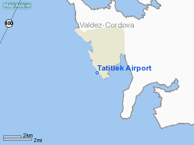
| Tatitlek Airport |
| IATA: TEK – ICAO: none – FAA LID: 7KA |
| Summary |
| Airport type |
Public |
| Owner |
Alaska DOT&PF - Northern Region |
| Serves |
Tatitlek, Alaska |
| Elevation AMSL |
62 ft / 19 m |
| Coordinates |
60°52′21″N 146°41′28″W / 60.8725°N 146.69111°W / 60.8725; -146.69111 |
| Runways |
| Direction |
Length |
Surface |
| ft |
m |
| 12/30 |
3,701 |
1,128 |
Gravel |
| 13W/31W |
8,000 |
2,438 |
Water |
| Statistics (2005) |
| Aircraft operations |
2,350 |
| Source: Federal Aviation Administration |
Tatitlek Airport (IATA: TEK, FAA LID: 7KA) is a state-owned public-use airport serving Tatitlek, in the Valdez-Cordova Census Area of the U.S. state of Alaska. Facilities and aircraft
Tatitlek Airport covers an area of 160 acres (65 ha) at an elevation of 62 feet (19 m) above mean sea level. It has one runway designated 12/30 with a gravel surface measuring is 3,701 by 75 feet (1,128 x 23 m). It also has one seaplane landing area designated 13W/31W which measures 8,000 by 4,000 feet (2,438 x 1,219 m).
For the 12-month period ending December 31, 2005, the airport had 2,350 aircraft operations, an average of 195 per month: 53% air taxi and 47% general aviation.
Airline and non-stop destinations
- Arctic Circle Air (Anchorage)
The above content comes from Wikipedia and is published under free licenses – click here to read more.
Location
& QuickFacts
|
FAA
Information Effective: |
2006-02-16 |
|
Airport
Identifier: |
7KA |
|
Longitude/Latitude: |
146-41-11.2750W/60-52-08.0590N
-146.686465/60.868905 (Estimated) |
|
Elevation: |
25 ft / 7.62 m (Estimated) |
|
Land: |
160 acres |
|
From
nearest city: |
0 nautical miles NW of Tatitlek, AK |
|
Location: |
Valdez-chitna-whitie County, AK |
|
Magnetic Variation: |
26E (1985) |
Owner
& Manager
|
Ownership: |
Publicly owned |
|
Owner: |
State Of Ak Dot&pf/n Reg |
|
Address: |
2301 Peger Rd
Fairbanks, AK 99701 |
|
Phone number: |
907-451-2204 |
|
Manager: |
Steve Searles |
|
Address: |
Po Box 507
Valdez, AK 99686 |
|
Phone number: |
907-835-5658 |
Airport
Operations and Facilities
|
Airport
Use: |
Open to public |
|
Wind
indicator: |
Yes |
|
Segmented
Circle: |
Yes |
|
Control
Tower: |
No |
|
Attendance
Schedule: |
UNATNDD |
|
Lighting
Schedule: |
DUSK-DAWN
ACTVT MIRL RY 12/30 - CTAF. |
|
Beacon
Color: |
Clear-Green (lighted land airport) |
|
Landing
fee charge: |
No |
|
Sectional
chart: |
Anchorage |
|
Region: |
AAL - Alaska |
|
Boundary
ARTCC: |
ZAN - Anchorage |
|
Tie-in
FSS: |
JNU - Juneau |
|
FSS
on Airport: |
No |
|
FSS
Phone: |
907-586-7380 |
|
FSS
Toll Free: |
1-800-WX-BRIEF |
|
NOTAMs
Facility: |
VDZ (NOTAM-d service avaliable) |
|
Federal Agreements: |
NGY |
Airport
Communications
Airport
Services
|
Airframe
Repair: |
NONE |
|
Power
Plant Repair: |
NONE |
|
Bottled
Oxygen: |
NONE |
|
Bulk
Oxygen: |
NONE |
|
Runway Information
Runway 12/30
|
Dimension: |
3700
x 75 ft / 1127.8 x 22.9 m
RWY SAFETY AREA 150 FT BY 4300 FT. |
|
Surface: |
GRVL, Good Condition
SAFETY AREAS ALL SIDES ROUGH WITH POT HOLES AND LARGE ROCKS.
SFC SLOPES GRADUALLY UPHILL FM RY 30 TO RY 12; RY 12 THLD 45 FT
HIGHER THAN RY 30 THLD. |
|
Edge
Lights: |
Medium |
|
|
Runway 12 |
Runway 30 |
|
Traffic
Pattern: |
Left |
Left |
|
Obstruction: |
9 ft trees, 115.0 ft from runway, 20 ft left
of centerline, 12:1 slope to clear |
60 ft trees, 1200.0 ft from runway, 300 ft
right of centerline, 20:1 slope to clear |
|
Runway 13W/31W
|
Dimension: |
8000
x 4000 ft / 2438.4 x 1219.2 m
RWY SAFETY AREA 150 FT BY 4300 FT. |
|
Surface: |
WATER,
SAFETY AREAS ALL SIDES ROUGH WITH POT HOLES AND LARGE ROCKS.
SFC SLOPES GRADUALLY UPHILL FM RY 30 TO RY 12; RY 12 THLD 45 FT
HIGHER THAN RY 30 THLD. |
|
|
Runway 13W |
Runway 31W |
|
Traffic
Pattern: |
Left |
Left |
|
Radio Navigation
Aids
|
ID |
Type |
Name |
Ch |
Freq |
Var |
Dist |
|
MNL |
NDB |
Mineral Creek |
|
524.00 |
27E |
18.2 nm |
|
ALJ |
NDB |
Orca Bay |
|
233.00 |
23E |
23.6 nm |
|
HBK |
NDB |
Hinchinbrook |
|
362.00 |
27E |
33.5 nm |
|
GCR |
NDB |
Glacier River |
|
404.00 |
22E |
42.0 nm |
|
JOH |
VOR/DME |
Johnstone Point |
114X |
116.70 |
27E |
23.5 nm |
Remarks
- CTN:
ROCKS IN WATER AREA AT LOW TIDES.
- HIGH
TERRAIN NW THROUGH N THROUGH E THROUGH SE.
- RY
CONDITION NOT MONITORED; RECOMMEND VISUAL INSPECTION PRIOR TO LANDING.
Based Aircraft
|
Aircraft
based on field: |
2 |
|
Single
Engine Airplanes: |
2 |
Operational Statistics
|
Aircraft
Operations: |
44/Week |
|
Air Taxi: |
55.6% |
|
General
Aviation Itinerant: |
44.4% |
Tatitlek Airport
Address:
Valdez-chitna-whitie County, AK
Tel:
907-451-2204, 907-835-5658
Images
and information placed above are from
http://www.airport-data.com/airport/7KA/
We
thank them for the data!
| General
Info |
| Country |
United
States |
| State |
ALASKA
|
| FAA ID |
7KA
|
| Latitude |
60-52-08.059N
|
| Longitude |
146-41-11.275W
|
| Elevation |
25 feet
|
| Near City |
TATITLEK
|
We don't guarantee the information is fresh and accurate. The data may
be wrong or outdated.
For more up-to-date information please refer to other sources.
|
|


