|
|
| Summit Airport |
 |
| IATA: UMM – ICAO: PAST – FAA LID: UMM |
| Summary |
| Airport type |
Public |
| Owner |
Alaska DOT&PF - Northern Region |
| Serves |
Summit, Alaska |
| Elevation AMSL |
2,409 ft / 734 m |
| Coordinates |
63°19′53″N 149°07′38″W / 63.33139°N 149.12722°W / 63.33139; -149.12722 |
| Runways |
| Direction |
Length |
Surface |
| ft |
m |
| 3/21 |
3,840 |
1,170 |
Gravel |
| Statistics (2005) |
| Aircraft operations |
800 |
| Source: Federal Aviation Administration |
Summit Airport (IATA: UMM, ICAO: PAST, FAA LID: UMM) is a state-owned public-use airport located in Summit, in the Matanuska-Susitna Borough of the U.S. state of Alaska. It is about six miles south-southwest of Cantwell, Alaska.
Facilities and aircraft
Summit Airport has one runway designated 3/21 with a gravel surface measuring 3,840 by 80 feet (1,170 x 24 m). For the 12-month period ending December 31, 2005, the airport had 800 aircraft operations, an average of 66 per month: 94% general aviation and 6% scheduled commercial.
The above content comes from Wikipedia and is published under free licenses – click here to read more.

Location
& QuickFacts
|
FAA
Information Effective: |
2006-02-16 |
|
Airport
Identifier: |
UMM |
|
Longitude/Latitude: |
149-07-38.2200W/63-19-53.3260N
-149.127283/63.331479 (Estimated) |
|
Elevation: |
2409 ft / 734.26 m (Surveyed) |
|
Land: |
0 acres |
|
From
nearest city: |
0 nautical miles N of Summit, AK |
|
Location: |
Mata-sus Borough County, AK |
|
Magnetic Variation: |
26E (1985) |
Owner
& Manager
|
Ownership: |
Publicly owned |
|
Owner: |
St Of Ak Dotpf Northern Reg |
|
Address: |
2301 Peger Rd
Fairbanks, AK 99701 |
|
Phone number: |
907-451-5217 |
|
Manager: |
Jack Phipps |
|
Address: |
Box 48
Cantwell, AK 99729 |
|
Phone number: |
907-768-2355 |
Airport
Operations and Facilities
|
Airport
Use: |
Open to public |
|
Wind
indicator: |
Yes |
|
Segmented
Circle: |
No |
|
Control
Tower: |
No |
|
Attendance
Schedule: |
UNATNDD |
|
Landing
fee charge: |
No |
|
Sectional
chart: |
Anchorage |
|
Region: |
AAL - Alaska |
|
Boundary
ARTCC: |
ZAN - Anchorage |
|
Tie-in
FSS: |
ENA - Kenai |
|
FSS
Phone: |
800-478-3576 |
|
FSS
Toll Free: |
1-800-WX-BRIEF |
|
NOTAMs
Facility: |
TTW (NOTAM-d service avaliable) |
Airport
Communications
Airport
Services
|
Airframe
Repair: |
NONE |
|
Power
Plant Repair: |
NONE |
|
Bottled
Oxygen: |
NONE |
|
Bulk
Oxygen: |
NONE |
|
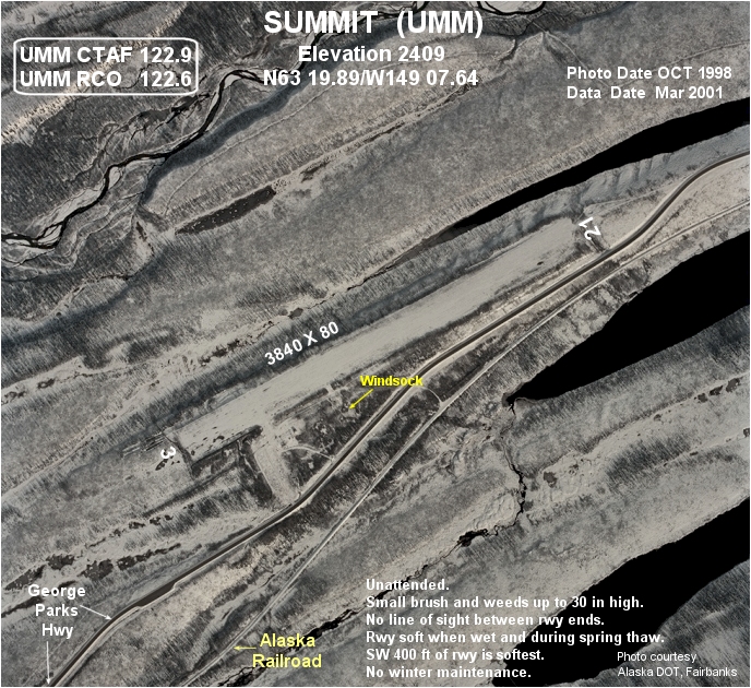
Runway Information
Runway 03/21
|
Dimension: |
3840 x 80 ft / 1170.4 x 24.4 m |
|
Surface: |
GRAVEL, Fair Condition |
|
|
Runway 03 |
Runway 21 |
|
Traffic
Pattern: |
Left |
Left |
|
Obstruction: |
15 ft tree, 315.0 ft from runway, 70 ft right
of centerline, 21:1 slope to clear |
, 50:1 slope to clear |
|
Radio Navigation
Aids
|
ID |
Type |
Name |
Ch |
Freq |
Var |
Dist |
|
UMM |
NDB |
Summit |
|
326.00 |
27E |
0.2 nm |
Remarks
- RWY
SUBJ TO CROSSWINDS.
- RY
NOT MAINTAINED & CONDITION NOT MONITORED, RECOMMEND VISUAL INSPECTION
PRIOR TO LANDING.
- SMALL
BRUSH & WEEDS UP TO 30 IN HIGH ON ALL BUT MIDDLE PORTION OF RWY.
- NO
LINE OF SIGHT BTN RY 03/21 ENDS.
- NO
WINTER MAINTENANCE.
Operational Statistics
|
Aircraft
Operations: |
17/Week |
|
Air Carrier: |
5.9% |
|
General
Aviation Itinerant: |
88.2% |
Summit Airport
Address:
Mata-sus Borough County, AK
Tel:
907-451-5217, 907-768-2355
Images
and information placed above are from
http://www.airport-data.com/airport/UMM/
We
thank them for the data!
| General
Info |
| Country |
United
States |
| State |
ALASKA
|
| FAA ID |
UMM
|
| Latitude |
63-19-53.326N
|
| Longitude |
149-07-38.220W
|
| Elevation |
2409 feet
|
| Near City |
SUMMIT
|
We don't guarantee the information is fresh and accurate. The data may
be wrong or outdated.
For more up-to-date information please refer to other sources.
|
|