|
|
South Naknek Nr 2 Airport |
South Naknek Airport
South Naknek Nr 2 Airport |
 |
| IATA: WSN – ICAO: PFWS – FAA LID: WSN |
| Summary |
| Airport type |
Public |
| Owner |
State of Alaska DOT&PF - Central Region |
| Serves |
South Naknek, Alaska |
| Elevation AMSL |
162 ft / 49 m |
| Coordinates |
58°42′08″N 157°00′09″W / 58.70222°N 157.0025°W / 58.70222; -157.0025 |
| Runways |
| Direction |
Length |
Surface |
| ft |
m |
| 4/22 |
2,264 |
690 |
Gravel |
| 12/30 |
3,314 |
1,010 |
Gravel/Dirt |
| Statistics (2008) |
| Aircraft operations |
3,530 |
| Enplanements (2008) |
330 |
| Source: Federal Aviation Administration |
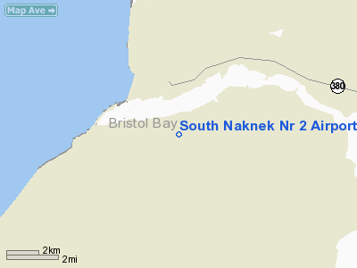
South Naknek Airport (IATA: WSN, ICAO: PFWS, FAA LID: WSN), also known as South Naknek Nr 2 Airport, is a state-owned public-use airport located one nautical mile (1.85 km) southwest of the central business district of South Naknek, in the Bristol Bay Borough of the U.S. state of Alaska.
As per Federal Aviation Administration records, this airport had 330 commercial passenger boardings (enplanements) in calendar year 2008, a decrease of 19% from the 409 enplanements in 2007. South Naknek Airport is included in the FAA's National Plan of Integrated Airport Systems (2009-2013), which categorizes it as a general aviation facility.
Facilities and aircraft
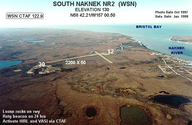
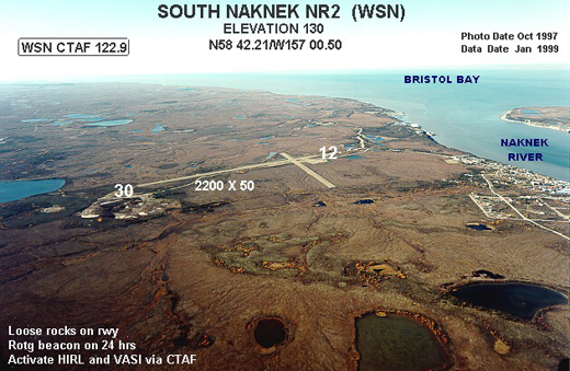
South Naknek Airport covers an area of 214 acres (87 ha) at an elevation of 162 feet (49 m) above mean sea level. It has two runways: 4/22 is 2,264 by 60 feet (690 x 18 m) with a gravel surface; 12/30 is 3,314 by 60 feet (1,010 x 18 m) with a gravel and dirt surface.
For the 12-month period ending December 31, 2008, the airport had 3,530 aircraft operations, an average of 294 per month: 94% air taxi and 6% general aviation.
The above content comes from Wikipedia and is published under free licenses – click here to read more.
Location
& QuickFacts
|
FAA
Information Effective: |
2006-02-16 |
|
Airport
Identifier: |
WSN |
|
Longitude/Latitude: |
157-00-29.7040W/58-42-12.3700N
-157.008251/58.703436 (Estimated) |
|
Elevation: |
130 ft / 39.62 m (Estimated) |
|
Land: |
214 acres |
|
From
nearest city: |
1 nautical miles SW of South Naknek, AK |
|
Location: |
Bristol Bay County, AK |
|
Magnetic Variation: |
21E (1985) |
Owner
& Manager
|
Ownership: |
Publicly owned |
|
Owner: |
St Of Ak Dotpf/c Rgn |
|
Address: |
Po Box 196900
Anchorage, AK 99519-6900 |
|
Phone
number: |
907-243-1735 |
|
Manager: |
John Fundeen |
|
Address: |
Po Box 65
King Salmon, AK 99613 |
|
Phone number: |
907-246-3325 |
Airport
Operations and Facilities
|
Airport
Use: |
Open to public |
|
Wind
indicator: |
Yes
WIND IND AT SE END OF ARPT MAY BE UNUSBL. |
|
Segmented
Circle: |
Yes |
|
Control
Tower: |
No |
|
Attendance
Schedule: |
UNATNDD |
|
Lighting
Schedule: |
DUSK-DAWN
ACTVT HIRL RY 12/30 & VASI RYS 12 & 30 - CTAF. |
|
Beacon
Color: |
Clear-Green (lighted land airport) |
|
Landing
fee charge: |
No |
|
Sectional
chart: |
Kodiak |
|
Region: |
AAL - Alaska |
|
Boundary
ARTCC: |
ZAN - Anchorage |
|
Tie-in
FSS: |
ENA - Kenai |
|
FSS
on Airport: |
No |
|
FSS
Phone: |
800-478-3576 |
|
FSS
Toll Free: |
1-800-WX-BRIEF |
|
NOTAMs
Facility: |
AKN (NOTAM-d service avaliable) |
|
Federal Agreements: |
NGSY |
Airport
Communications
Airport
Services
|
Airframe
Repair: |
NONE |
|
Power
Plant Repair: |
NONE |
|
Bottled
Oxygen: |
NONE |
|
Bulk
Oxygen: |
NONE |
|
Runway Information
Runway 04/22
|
Dimension: |
2260 x 60 ft / 688.8 x 18.3 m |
|
Surface: |
GRVL, Fair Condition
RY UNEVEN WITH DIPS AND SWALES FULL LENGTH OF RY - EDGES SOFT AND
RUTTED, WASHOUTS ON SHOULDERS TO 6 INCHES TRAIL CROSSES RY 04 650
FT FROM THSD. |
|
|
Runway 04 |
Runway 22 |
|
Traffic
Pattern: |
Left |
Left |
|
Runway 12/30
|
Dimension: |
3310 x 60 ft / 1008.9 x 18.3 m |
|
Surface: |
GRVL-DIRT, Fair Condition
RY UNEVEN WITH DIPS AND SWALES FULL LENGTH OF RY - EDGES SOFT AND
RUTTED, WASHOUTS ON SHOULDERS TO 6 INCHES TRAIL CROSSES RY 04 650
FT FROM THSD. |
|
Edge
Lights: |
High |
|
|
Runway 12 |
Runway 30 |
|
Traffic
Pattern: |
Left |
Left |
|
Crossing
Height: |
25.00 ft |
25.00 ft |
|
VASI: |
4-box on left side |
4-box on left side |
|
Visual
Glide Angle: |
3.00� |
3.00� |
|
Radio Navigation
Aids
|
ID |
Type |
Name |
Ch |
Freq |
Var |
Dist |
|
AK |
NDB |
Saldo |
|
355.00 |
21E |
7.5 nm |
|
HCP |
NDB |
Kulik Lake |
|
334.00 |
21E |
47.7 nm |
|
AKN |
VORTAC |
King Salmon |
075X |
112.80 |
21E |
8.1 nm |
Remarks
- RWY
COND NOT MONITORED; RECOMMEND VISUAL INSPECTION PRIOR TO USING.
- TWY
SLOPES DOWNHILL TO THE NW. NO LINE OF SIGHT BETWEEN END OF TWY &
RY 12/30.
- PILOTS
ARE REQUESTED TO SELF-ANNOUNCE ON CTAF PRIOR TO TAXIING ON RWY FOR DEPARTURE;
LEAVING THE RWY AND WITHIN 10 NM OF THE ARPT WHEN APPROACHING TO LAND.
Based Aircraft
|
Aircraft
based on field: |
10 |
|
Single
Engine Airplanes: |
10 |
Operational Statistics
|
Aircraft
Operations: |
43/Week |
|
Air Taxi: |
56.8% |
|
General
Aviation Local: |
40.9% |
|
General
Aviation Itinerant: |
2.3% |
South Naknek Nr 2 Airport
Address:
Bristol Bay County, AK
Tel:
907-243-1735,
907-246-3325
Images
and information placed above are from
http://www.airport-data.com/airport/WSN/
We
thank them for the data!
| General
Info |
| Country |
United
States |
| State |
ALASKA
|
| FAA ID |
WSN
|
| Latitude |
58-42-12.370N
|
| Longitude |
157-00-29.704W
|
| Elevation |
130 feet
|
| Near City |
SOUTH
NAKNEK |
We don't guarantee the information is fresh and accurate. The data may
be wrong or outdated.
For more up-to-date information please refer to other sources.
|
|