|
|
| Shishmaref Airport |
 |
| IATA: SHH – ICAO: PASH – FAA LID: SHH |
| Summary |
| Airport type |
Public |
| Owner |
Alaska DOT&PF - Northern Region |
| Serves |
Shishmaref, Alaska |
| Elevation AMSL |
12 ft / 4 m |
| Coordinates |
66°14′58″N 166°05′22″W / 66.24944°N 166.08944°W / 66.24944; -166.08944 |
| Runways |
| Direction |
Length |
Surface |
| ft |
m |
| 5/23 |
5,000 |
1,524 |
Asphalt |
| Source: Federal Aviation Administration |
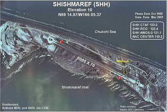
Shishmaref Airport (IATA: SHH, ICAO: PASH, FAA LID: SHH) is a state-owned public-use airport located one nautical mile (1.85 km) south of the central business district of Shishmaref, a village in the Nome Census Area of the U.S. state of Alaska. It has one asphalt paved runway designated 5/23 and measuring 5,000 x 70 ft. (1,524 x 21 m). Shishmaref is located on Sarichef Island in the Chukchi Sea, just north of the Bering Strait and five miles from the mainland.
As per Federal Aviation Administration records, the airport had 5,040 commercial passenger boardings (enplanements) in calendar year 2006 and 4,732 enplanements in 2007. According to the FAA's National Plan of Integrated Airport Systems (NPIAS), it is classified as commercial service - non-primary because it has between 2,500 and 10,000 passenger boardings per year.
Airlines
- Bering Air
- Frontier Flying Service
- Hageland Aviation Services
The above content comes from Wikipedia and is published under free licenses – click here to read more.
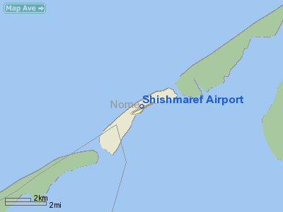
Location
& QuickFacts
|
FAA
Information Effective: |
2006-02-16 |
|
Airport
Identifier: |
SHH |
|
Longitude/Latitude: |
166-05-21.6450W/66-14-58.4400N
-166.089346/66.249567 (Estimated) |
|
Elevation: |
12 ft / 3.66 m (Estimated) |
|
Land: |
0 acres |
|
From
nearest city: |
1 nautical miles S of Shishmaref, AK |
|
Location: |
Nome County, AK |
|
Magnetic Variation: |
14E (2005) |
Owner
& Manager
|
Ownership: |
Publicly owned |
|
Owner: |
State Of Ak Dotpf N Rgn |
|
Address: |
2301 Peger Rd
Fairbanks, AK 99709 |
|
Phone number: |
907-443-3444 |
|
Manager: |
Jerry Oliver |
|
Address: |
Box 1048
Nome, AK 99762 |
|
Phone number: |
907-443-2500 |
Airport
Operations and Facilities
|
Airport
Use: |
Open to public |
|
Wind
indicator: |
Yes |
|
Segmented
Circle: |
Yes |
|
Control
Tower: |
No |
|
Attendance
Schedule: |
UNATNDD |
|
Lighting
Schedule: |
DUSK-DAWN
ACTVT MIRL RY 05/23 & VASI RYS 05 & 23 - CTAF. |
|
Beacon
Color: |
Clear-Green (lighted land airport) |
|
Sectional
chart: |
Nome |
|
Region: |
AAL - Alaska |
|
Boundary
ARTCC: |
ZAN - Anchorage |
|
Tie-in
FSS: |
OME - Nome |
|
FSS
Phone: |
LC 443-2291 |
|
FSS
Toll Free: |
1-800-478-8400 |
|
Alternate
FSS: |
FAI - Fairbanks |
|
Alt.
FSS Toll Free: |
1-866-248-6516 |
|
NOTAMs
Facility: |
SHH (NOTAM-d service avaliable) |
|
Federal Agreements: |
NGSY |
Airport
Communications
|
Runway Information
Runway 05/23
|
Dimension: |
5000 x 70 ft / 1524.0 x 21.3 m |
|
Surface: |
ASPH, Poor Condition
ROUGH AREA 10 FT BY 15 FT 90 FT FROM RY 05 THLD FROM RIGHT EDGE
TO 10 FT TOWARD CNTRLN. |
|
Weight
Limit: |
Single wheel: 12500 lbs.
MAX ACFT WGT; NO LIMIT WHEN FROZEN. |
|
Edge
Lights: |
Medium |
|
|
Runway 05 |
Runway 23 |
|
Longitude: |
166-06-16.2500W |
166-04-27.0400W |
|
Latitude: |
66-14-47.4600N |
66-15-09.4200N |
|
Elevation: |
10.00 ft |
12.00 ft |
|
Alignment: |
63 |
127 |
|
Traffic
Pattern: |
Left |
Left |
|
Markings: |
Non-precision instrument, Fair Condition |
Non-precision instrument, Fair Condition |
|
Crossing
Height: |
25.00 ft |
25.00 ft |
|
VASI: |
4-box on left side |
4-box on left side |
|
Visual
Glide Angle: |
3.00� |
3.00� |
|
Obstruction: |
, 50:1 slope to clear |
105 ft ant, 4000.0 ft from runway, 800 ft right
of centerline, 38:1 slope to clear |
|
Radio Navigation
Aids
|
ID |
Type |
Name |
Ch |
Freq |
Var |
Dist |
|
SHH |
NDB |
Shishmaref |
|
365.00 |
14E |
1.0 nm |
Remarks
- NW-SE
PREVAILING WINDS.
- WHEN
AVBL WEA RPRTS HRLY ONLY.
- RY
SAFETY AREA DIMENSIONS (150' X 5600').
- FIRST
95 FT OF SAFETY AREA USBL AT NE END OF RY.
Shishmaref Airport
Address:
Nome County, AK
Tel:
907-443-3444, 907-443-2500
Images
and information placed above are from
http://www.airport-data.com/airport/SHH/
We
thank them for the data!
| General
Info |
| Country |
United
States |
| State |
ALASKA
|
| FAA ID |
SHH
|
| Latitude |
66-14-58.447N
|
| Longitude |
166-05-22.412W
|
| Elevation |
10 feet
|
| Near City |
SHISHMAREF |
We don't guarantee the information is fresh and accurate. The data may
be wrong or outdated.
For more up-to-date information please refer to other sources.
|
|