|
|
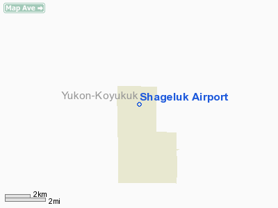
| Shageluk Airport |
 |
| IATA: SHX – ICAO: PAHX – FAA LID: SHX |
| Summary |
| Airport type |
Public |
| Owner |
Alaska DOT&PF - Northern Region |
| Serves |
Shageluk, Alaska |
| Elevation AMSL |
79 ft / 24 m |
| Coordinates |
62°41′32″N 159°34′09″W / 62.69222°N 159.56917°W / 62.69222; -159.56917 |
| Runways |
| Direction |
Length |
Surface |
| ft |
m |
| 16/34 |
3,400 |
1,036 |
Gravel |
| 18W/36W |
5,000 |
1,524 |
Water |
| Source: Federal Aviation Administration |
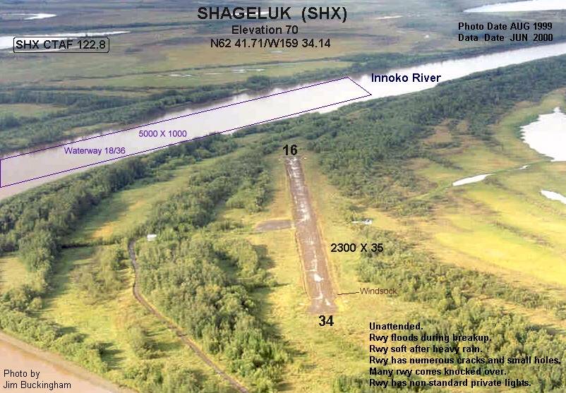
Shageluk Airport (IATA: SHX, ICAO: PAHX, FAA LID: SHX) is a state-owned public-use airport located one nautical mile (1.85 km) north of the central business district of Shageluk, a city in the Yukon-Koyukuk Census Area of the U.S. state of Alaska. Facilities
Shageluk Airport covers an area of 148 acres (60 ha) at an elevation of 79 feet (24 m) above mean sea level. It has one runway designated 16/34 with a gravel surface measuring 3,400 by 50 feet (1,036 x 15 m) (expanded from the prior size of 2,200 by 35 feet). It also has a seaplane landing area on the Innoko River designated 18W/36W which measures 5,000 by 1,000 feet.
Airlines
- Frontier Flying Service
- Hageland Aviation Services
The above content comes from Wikipedia and is published under free licenses – click here to read more.
Location
& QuickFacts
|
FAA
Information Effective: |
2006-02-16 |
|
Airport
Identifier: |
SHX |
|
Longitude/Latitude: |
159-34-09.1600W/62-41-32.2750N
-159.569211/62.692299 (Estimated) |
|
Elevation: |
109 ft / 33.22 m (Estimated) |
|
Land: |
148 acres |
|
From
nearest city: |
1 nautical miles N of Shageluk, AK |
|
Location: |
Kuskokwim County, AK |
|
Magnetic Variation: |
20E (1985) |
Owner
& Manager
|
Ownership: |
Publicly owned |
|
Owner: |
St Of Ak Dotpf Northern Rgn |
|
Address: |
2301 Peger Road
Fairbanks, AK 99709 |
|
Phone number: |
907-443-3444 |
|
Manager: |
George Beans |
|
Address: |
Box 135
St Mary's, AK 99658 |
|
Phone number: |
907-438-2416 |
Airport
Operations and Facilities
|
Airport
Use: |
Open to public |
|
Wind
indicator: |
Yes |
|
Segmented
Circle: |
Yes |
|
Control
Tower: |
No |
|
Attendance
Schedule: |
UNATNDD |
|
Lighting
Schedule: |
DUSK-DAWN
ACTVT MIRL RY 16/34, PAPI & REIL RY 34 - CTAF |
|
Beacon
Color: |
Clear-Green (lighted land airport) |
|
Landing
fee charge: |
No |
|
Sectional
chart: |
Mc Grath |
|
Region: |
AAL - Alaska |
|
Boundary
ARTCC: |
ZAN - Anchorage |
|
Tie-in
FSS: |
ENA - Kenai |
|
FSS
on Airport: |
No |
|
FSS
Phone: |
800-478-3576 |
|
FSS
Toll Free: |
1-800-WX-BRIEF |
|
NOTAMs
Facility: |
ANV (NOTAM-d service avaliable) |
|
Federal Agreements: |
N |
Airport
Communications
|
CTAF: |
122.800 |
|
Unicom: |
122.800 |
Airport
Services
|
Airframe
Repair: |
NONE |
|
Power
Plant Repair: |
NONE |
|
Bottled
Oxygen: |
NONE |
|
Bulk
Oxygen: |
NONE |
|
Runway Information
Runway 16/34
|
Dimension: |
3400 x 50 ft / 1036.3 x 15.2 m |
|
Surface: |
GRVL, Fair Condition |
|
Edge
Lights: |
Medium |
|
|
Runway 16 |
Runway 34 |
|
Longitude: |
159-34-09.3600W |
159-34-08.9600W |
|
Latitude: |
62-41-49.0100N |
62-41-15.5400N |
|
Elevation: |
109.00 ft |
109.00 ft |
|
Alignment: |
127 |
127 |
|
Traffic
Pattern: |
Left |
Left |
|
Crossing
Height: |
0.00 ft |
25.00 ft |
|
VASI: |
|
4-light PAPI on left side
PAPI RY 34 OTS INDEFLY. |
|
Visual
Glide Angle: |
0.00� |
3.00� |
|
Runway
End Identifier: |
Yes
OTS INDEFLY. |
Yes
OTS INDEFLY. |
|
Obstruction: |
, 50:1 slope to clear |
15 ft brush, 750.0 ft from runway, 40 ft right
of centerline, 50:1 slope to clear |
|
Runway 18W/36W
|
Dimension: |
5000 x 1000 ft / 1524.0 x 304.8 m |
|
Surface: |
WATER, |
|
|
Runway 18W |
Runway 36W |
|
Traffic
Pattern: |
Left |
Left |
|
Radio Navigation
Aids
|
ID |
Type |
Name |
Ch |
Freq |
Var |
Dist |
|
ANV |
NDB/DME |
Anvik |
071X |
365.00 |
20E |
17.4 nm |
Remarks
- SPB
OPERG AREA IN INNOKO RIVER ADJ TO VILLAGE.
- FLOODS
DURG BREAKUP; MAY BE SOFT AFTER HEAVY RAIN.
- RY
CONDITON NOT MONITORED; RECOMMEND VISUAL INSPECTION PRIOR TO LANDING.
- ESTABD
PRIOR TO 1959.
Shageluk Airport
Address:
Kuskokwim County, AK
Tel:
907-443-3444, 907-438-2416
Images
and information placed above are from
http://www.airport-data.com/airport/SHX/
We
thank them for the data!
| General
Info |
| Country |
United
States |
| State |
ALASKA
|
| FAA ID |
SHX
|
| Latitude |
62-41-42.430N
|
| Longitude |
159-34-08.621W
|
| Elevation |
70 feet
|
| Near City |
SHAGELUK
|
We don't guarantee the information is fresh and accurate. The data may
be wrong or outdated.
For more up-to-date information please refer to other sources.
|
|