 |
|
| Sand Point Airport |
| IATA: SDP – ICAO: PASD – FAA LID: SDP |
| Summary |
| Airport type |
Public |
| Owner |
Alaska DOT&PF - Central Region |
| Serves |
Sand Point, Alaska |
| Elevation AMSL |
21 ft / 6 m |
| Coordinates |
55°18′49″N 160°31′17″W / 55.31361°N 160.52139°W / 55.31361; -160.52139 |
| Runways |
| Direction |
Length |
Surface |
| ft |
m |
| 13/31 |
5,213 |
1,589 |
Asphalt |
| Statistics (2003) |
| Aircraft operations |
2,012 |
| Enplanements (2008) |
4,296 |
| Source: Federal Aviation Administration |
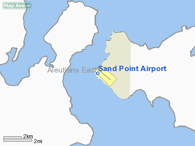
Sand Point Airport (IATA: SDP, ICAO: PASD, FAA LID: SDP) is a state-owned public-use airport located two nautical miles (4 km) southwest of the central business district of Sand Point, a city in the Aleutians East Borough in the U.S. state of Alaska. Scheduled airline service to Anchorage International Airport is provided by Peninsula Airways (PenAir).
As per Federal Aviation Administration records, this airport had 4,296 commercial passenger boardings (enplanements) in calendar year 2008, an increase of 5% from the 4,105 enplanements in 2007. Sand Point Airport is included in the FAA's National Plan of Integrated Airport Systems (2009-2013) as a commercial service - non-primary facility. Airlines and destinations
Facilities and aircraft
Sand Point Airport has one asphalt paved runway designated 13/31 which measures 5,213 by 150 feet (1,589 x 46 m). For the 12-month period ending December 16, 2003, the airport had 2,012 aircraft operations, an average of 167 per month: 60% general aviation, 33% air taxi and 8% scheduled commercial.
The above content comes from Wikipedia and is published under free licenses – click here to read more.
Location
& QuickFacts
|
FAA
Information Effective: |
2006-02-16 |
|
Airport
Identifier: |
SDP |
|
Longitude/Latitude: |
160-31-03.7000W/55-18-54.1000N
-160.517694/55.315028 (Estimated) |
|
Elevation: |
21 ft / 6.40 m (Surveyed) |
|
Land: |
0 acres |
|
From
nearest city: |
2 nautical miles SW of Sand Point, AK |
|
Location: |
Aleutian Islands County, AK |
|
Magnetic Variation: |
18E (1985) |
Owner
& Manager
|
Ownership: |
Publicly owned |
|
Owner: |
State Of Ak Dotpf-central Rgn |
|
Address: |
P.o. Box 196900
Anchorage, AK 99519-6900 |
|
Phone number: |
907-269-0747 |
|
Manager: |
Hap Kremer |
|
Address: |
Box 97
Cold Bay, AK 99571 |
|
Phone number: |
907-532-5000 |
Airport
Operations and Facilities
|
Airport
Use: |
Open to public |
|
Wind
indicator: |
Yes |
|
Segmented
Circle: |
Yes |
|
Control
Tower: |
No |
|
Attendance
Schedule: |
UNATNDD |
|
Lighting
Schedule: |
DUSK-DAWN
ACTVT MIRL RY 13/31; REIL AND VASI RYS 13 & 31 - CTAF. |
|
Beacon
Color: |
Clear-Green (lighted land airport) |
|
Landing
fee charge: |
No |
|
Sectional
chart: |
Cold Bay |
|
Region: |
AAL - Alaska |
|
Boundary
ARTCC: |
ZAN - Anchorage |
|
Tie-in
FSS: |
CDB - Cold Bay |
|
FSS
on Airport: |
No |
|
FSS
Phone: |
907-532-2454 |
|
FSS
Toll Free: |
1-800-478-7250 |
|
Alternate
FSS: |
ENA - Kenai |
|
Alt.
FSS Toll Free: |
1-800-WX-BRIEF |
|
NOTAMs
Facility: |
SDP (NOTAM-d service avaliable) |
|
Certification
type/date: |
I AS 5/1973
CLSD TO ACR OPNS WITH MORE THAN 30 PSGR SEATS EXCP PPR IN
WRITING TO AMGR PO BOX 97; COLD BAY AK 99571. |
|
Federal Agreements: |
NGSY |
Airport
Communications
|
CTAF: |
122.300 |
|
Unicom: |
122.800 |
Airport
Services
|
Fuel
available: |
A
FUEL AVBL 0800 - 2000 CALL 907-383-2026, $40 CALL OUT FEE. |
|
Airframe
Repair: |
NONE |
|
Power
Plant Repair: |
NONE |
|
Bottled
Oxygen: |
NONE |
|
Bulk
Oxygen: |
NONE |
|
Runway Information
Runway 13/31
|
Dimension: |
4000 x 150 ft / 1219.2 x 45.7 m |
|
Surface: |
ASPH, Good Condition |
|
Surface
Treatment: |
Saw-cut or plastic Grooved |
|
Weight
Limit: |
Single wheel: 75000 lbs.
Dual wheel: 200000 lbs.
Dual
tandem wheel: 300000 lbs. |
|
Edge
Lights: |
Medium |
|
|
Runway 13 |
Runway 31 |
|
Longitude: |
160-31-39.5000W |
160-31-03.7000W |
|
Latitude: |
55-19-11.0000N |
55-18-37.3000N |
|
Elevation: |
16.00 ft |
21.00 ft |
|
Alignment: |
127 |
127 |
|
ILS
Type: |
MLS |
|
|
Traffic
Pattern: |
Right |
Left |
|
Markings: |
Non-precision instrument, |
Non-precision instrument, |
|
Crossing
Height: |
27.00 ft |
27.00 ft |
|
VASI: |
4-box on left side |
4-box on right side |
|
Visual
Glide Angle: |
3.60� |
3.60� |
|
Runway
End Identifier: |
Yes |
Yes |
|
Remarks
- SEA
BIRDS INVOF RY APCHS.
- CLIFF
80-120 FT HIGH ON E SIDE OF RY. CLIFFS MAY OBSTRUCT VIEW OF RY 31 WHILE
ON APCH; TURBULENCE ON S APCH.
- EROSION
IN THE SAFETY AREA; 60 FT FM RY EDGE WEST SIDE.
- ARFF
EQUIP AVBL DURG PERIODS OF ACR OPNS ONLY.
- NO
SNOW REMOVAL OR DEICING 1800-0930 FOR RWY/TWY OR RAMP.
- SNOW
REMOVAL ICE REMOVAL & HAZ RPRTNG ONLY PERFORMED BY PRIOR ARNGMT
IN WRITING WITH ARPT MANAGEMENT.
- MAINTENANCE
DUTY HRS 0800-1700.
- PILOTS
ARE REQUESTED TO SELF-ANNOUNCE ON CTAF PRIOR TO TAXIING ON RWY FOR DEPARTURE;
LEAVING THE RWY AND WITHIN 10 NM OF THE ARPT WHEN APPROACHING TO LAND.
Based Aircraft
|
Aircraft
based on field: |
6 |
|
Single
Engine Airplanes: |
6 |
Operational Statistics
|
Aircraft
Operations: |
42/Week |
|
Air Carrier: |
7.2% |
|
Air Taxi: |
30.3% |
|
General
Aviation Local: |
36.9% |
|
General
Aviation Itinerant: |
18.5% |
Sand Point Airport
Address:
Aleutian Islands County, AK
Tel:
907-269-0747, 907-532-5000
Images
and information placed above are from
http://www.airport-data.com/airport/SDP/
We
thank them for the data!
| General
Info |
| Country |
United
States |
| State |
ALASKA
|
| FAA ID |
SDP
|
| Latitude |
55-18-54.100N
|
| Longitude |
160-31-03.700W
|
| Elevation |
21 feet
|
| Near City |
SAND POINT
|
We don't guarantee the information is fresh and accurate. The data may
be wrong or outdated.
For more up-to-date information please refer to other sources.
|
|


