 |
|
Ralph Wien Memorial Airport |
| Ralph Wien Memorial Airport |
 |
| IATA: OTZ – ICAO: PAOT – FAA LID: OTZ |
| Summary |
| Airport type |
Public |
| Owner |
Alaska DOT&PF - Northern Region |
| Serves |
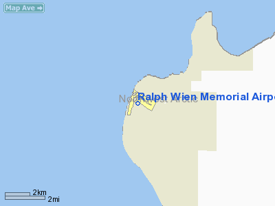
Kotzebue, Alaska |
| Elevation AMSL |
14 ft / 4 m |
| Coordinates |
66°53′05″N 162°35′55″W / 66.88472°N 162.59861°W / 66.88472; -162.59861 |
| Runways |
| Direction |
Length |
Surface |
| ft |
m |
| 9/27 |
5,900 |
1,798 |
Asphalt |
| 17/35 |
3,876 |
1,181 |
Gravel |
| Statistics (2004) |
| Aircraft operations |
59,860 |
| Based aircraft |
52 |
| Source: Federal Aviation Administration |
Ralph Wien Memorial Airport (IATA: OTZ, ICAO: PAOT, FAA LID: OTZ) is a state-owned public-use airport located one nautical mile (1.85 km) south of the central business district of Kotzebue, a city in the Northwest Arctic Borough of the U.S. state of Alaska. Facilities and aircraft
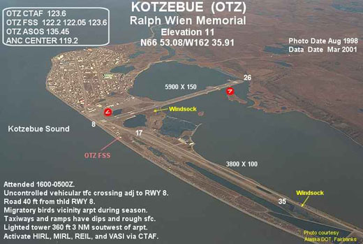
Ralph Wien Memorial Airport covers an area of 1,480 acres (599 ha) which contains two runways. Runway 9/27 has an asphalt paved surface measuring 5,900 x 150 ft (1,798 x 46 m) and runway 17/35 has a gravel surface measuring 3,876 x 90 ft (1,181 x 27 m).
For the 12-month period ending April 11, 2008, the airport had 59,860 aircraft operations, an average of 164 per day: 62% general aviation, 33% air taxi, 3% scheduled commercial and 2% military. There are 52 aircraft based at this airport: 77% single engine and 23% multi-engine.
Airlines and non-stop destinations
- Alaska Airlines (Anchorage, Nome)
- Bering Air (Ambler, Buckland, Deering, Kiana, Kivalina, Kobuk, Noatak, Nome, Noorvik, Point Hope, Selawik, Shungnak)
- Everts Air
- Frontier Flying Service
- Hageland Aviation Services (Noatak, Noorvik, Selawik, Kiana, Deering, Point Hope, Ambler)
The above content comes from Wikipedia and is published under free licenses – click here to read more.
Location
& QuickFacts
|
FAA
Information Effective: |
2006-02-16 |
|
Airport
Identifier: |
OTZ |
|
Longitude/Latitude: |
162-35-54.7790W/66-53-04.8370N
-162.598550/66.884677 (Estimated) |
|
Elevation: |
11 ft / 3.35 m (Surveyed) |
|
Land: |
1480 acres |
|
From
nearest city: |
1 nautical miles S of Kotzebue, AK |
|
Location: |
Kobuk County, AK |
|
Magnetic Variation: |
19E (1980) |
Owner
& Manager
|
Ownership: |
Publicly owned |
|
Owner: |
St Of Ak Dotpf-n Reg |
|
Address: |
2301 Peger Rd
Fairbanks, AK 99701 |
|
Phone number: |
907-451-5250 |
|
Manager: |
Kenny Gallahorn |
|
Address: |
Box 55
Kotzebue, AK 99752 |
|
Phone number: |
907-442-3147 |
Airport
Operations and Facilities
|
Airport
Use: |
Open to public |
|
Wind
indicator: |
Yes |
|
Segmented
Circle: |
Yes |
|
Control
Tower: |
No |
|
Attendance
Schedule: |
ALL/ALL/0600-2100 |
|
Lighting
Schedule: |
DUSK-DAWN
HIRL RY 08/26 & MIRL RY 17/35 OPERS 0800-2345 OTR HRS
ACTVT - CTAF.
ACTVT REIL & VASI RYS 08 & 26 - CTAF. |
|
Beacon
Color: |
Clear-Green (lighted land airport) |
|
Landing
fee charge: |
No |
|
Sectional
chart: |
Nome |
|
Region: |
AAL - Alaska |
|
Boundary
ARTCC: |
ZAN - Anchorage |
|
Tie-in
FSS: |
OTZ - Kotzebue |
|
FSS
on Airport: |
Yes |
|
FSS
Phone: |
907-442-3310 |
|
FSS
Toll Free: |
1-478-7460 |
|
Alternate
FSS: |
FAI - Fairbanks |
|
Alt.
FSS Toll Free: |
1-866-248-6516 |
|
NOTAMs
Facility: |
OTZ (NOTAM-d service avaliable) |
|
Certification type/date: |
I BS 5/1973 |
|
Federal Agreements: |
NGSY |
Airport
Communications
|
CTAF: |
123.600 |
|
Unicom: |
122.800 |
Airport
Services
|
Fuel
available: |
100 A |
|
Airframe
Repair: |
MINOR |
|
Power
Plant Repair: |
MINOR |
|
Bottled
Oxygen: |
NONE |
|
Bulk
Oxygen: |
NONE |
|
Runway Information
Runway 08/26
|
Dimension: |
5900 x 150 ft / 1798.3 x 45.7 m |
|
Surface: |
ASPH, Good Condition |
|
Surface
Treatment: |
Saw-cut or plastic Grooved |
|
Weight
Limit: |
Single wheel: 100000 lbs.
Dual wheel: 128000 lbs.
Dual
tandem wheel: 240000 lbs. |
|
Edge
Lights: |
High
& 17/35 LGTS EXTEND 30 INCHES ABOVE GND. |
|
|
Runway 08 |
Runway 26 |
|
Longitude: |
162-36-33.7170W |
162-34-09.1070W |
|
Latitude: |
66-53-21.9660N |
66-53-10.0990N |
|
Elevation: |
10.00 ft |
11.00 ft |
|
Alignment: |
102 |
127 |
|
ILS
Type: |
ILS/DME
|
|
|
Traffic
Pattern: |
Left |
Left |
|
Markings: |
Precision instrument, Good Condition |
Precision instrument, Good Condition |
|
Crossing
Height: |
0.00 ft |
57.00 ft |
|
VASI: |
4-box on left side |
4-box on left side |
|
Visual
Glide Angle: |
0.00� |
3.50� |
|
RVR
Equipment: |
touchdown |
|
|
Runway
End Identifier: |
Yes |
Yes |
|
Obstruction: |
15 ft road, 30.0 ft from runway
ROAD 30 FT FROM THR. |
38 ft hill, 800.0 ft from runway, 15:1 slope
to clear |
|
Runway 17/35
|
Dimension: |
3800 x 90 ft / 1158.2 x 27.4 m |
|
Surface: |
GRAVEL, Fair Condition |
|
Edge
Lights: |
Medium
& 17/35 LGTS EXTEND 30 INCHES ABOVE GND. |
|
|
Runway 17 |
Runway 35 |
|
Longitude: |
162-36-33.5890W |
162-36-57.0370W |
|
Latitude: |
66-53-06.4790N |
66-52-29.2710N |
|
Elevation: |
8.00 ft |
8.00 ft |
|
Alignment: |
127 |
14 |
|
Traffic
Pattern: |
Left |
Left |
|
Obstruction: |
15 ft road, 400.0 ft from runway, 26:1 slope
to clear |
15 ft , 50:1 slope to clear |
|
Radio Navigation
Aids
|
ID |
Type |
Name |
Ch |
Freq |
Var |
Dist |
|
HHM |
NDB |
Hotham |
|
356.00 |
19E |
1.3 nm |
|
OQK |
NDB/DME |
Noatak |
039X |
414.00 |
19E |
42.2 nm |
|
OTZ |
VOR/DME |
Kotzebue |
104X |
115.70 |
19E |
1.4 nm |
Remarks
- UNCTLD
VEHICULAR TFC CROSSING ADJACENT TO RWY 08.
- NO
SNOW REMOVAL OR DEICING BETWEEN HRS OF 2100-0600.
- SNOW
REMOVAL/ICE REMOVAL & ARPT HAZARDOUS REPORTING ONLY PERFORMED DURING
DUTY HRS UNLESS BY PRIOR ARRANGEMENT IN WRITING WITH ARPT MANAGEMENT.UNCONTROLLED
VEH ACCESS TO RY 17/35.
- RY
17/35 ACFT OPERATIONS GREATER THAN 49 FT WINGSPAN APPROVED WITH PPR
FROM AMGR.
- PARKING
AREA NOT LGTD.
- RY
COND REPORTS WILL REFLECT CONDS DURING DAY OPERS ONLY 0700-2000.
- TWYS
AND RAMPS HAVE NUMEROUS DIPS AND ROUGH SURFACES.
- REVIEW
OF ROAD LOCATION /PENDING/.
Based Aircraft
|
Aircraft
based on field: |
52 |
|
Single
Engine Airplanes: |
40 |
|
Multi
Engine Airplanes: |
12 |
Major Carriers
Serving This Airport
Most Popular Destinations
| Nome (OME) |
66.7% |
|
Ted Stevens Anchorage Intl (ANC) |
33.3% |
Most Popular Aircraft
|
N747AS |
16.7% |
| N746AS |
16.3% |
|
N741AS |
15.9% |
| N745AS |
14.1% |
|
N730AS |
10.5% |
| N742AS |
10.1% |
|
000000 |
6.9% |
| N740AS |
6.2% |
|
N754AS |
1.1% |
| N779AS |
0.7% |
Operational Statistics
|
Aircraft
Operations: |
170/Day |
|
Air Carrier: |
3.2% |
|
Air Taxi: |
32.3% |
|
General
Aviation Local: |
11.3% |
|
General
Aviation Itinerant: |
48.4% |
|
Military: |
1.6% |
Ralph Wien Memorial Airport
Address:
Kobuk County, AK
Tel:
907-451-5250, 907-442-3147
Images
and information placed above are from
http://www.airport-data.com/airport/OTZ/
We
thank them for the data!
| General
Info |
| Country |
United
States |
| State |
ALASKA
|
| FAA ID |
OTZ
|
| Latitude |
66-53-04.837N
|
| Longitude |
162-35-54.779W
|
| Elevation |
11 feet
|
| Near City |
KOTZEBUE
|
We don't guarantee the information is fresh and accurate. The data may
be wrong or outdated.
For more up-to-date information please refer to other sources.
|
|


