 |
|
Ralph M Calhoun Memorial Airport |
| Ralph M. Calhoun Memorial Airport |
 |
| IATA: TAL – ICAO: PATA – FAA LID: TAL |
| Summary |
| Airport type |
Public |
| Owner |
Alaska DOT&PF - Northern Region |
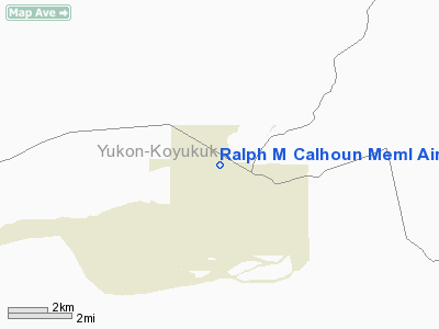
| Serves |
Tanana, Alaska |
| Elevation AMSL |
236 ft / 72 m |
| Coordinates |
65°10′28″N 152°06′34″W / 65.17444°N 152.10944°W / 65.17444; -152.10944 |
| Runways |
| Direction |
Length |
Surface |
| ft |
m |
| 7/25 |
4,400 |
1,341 |
Gravel |
| Statistics (2005) |
| Aircraft operations |
3,100 |
| Source: Federal Aviation Administration |
Ralph M. Calhoun Memorial Airport (IATA: TAL, ICAO: PATA, FAA LID: TAL) is a state-owned public-use airport located one nautical mile (1.85 km) west of the central business district of Tanana, a city in the Yukon-Koyukuk Census Area of the U.S. state of Alaska. Facilities and aircraft
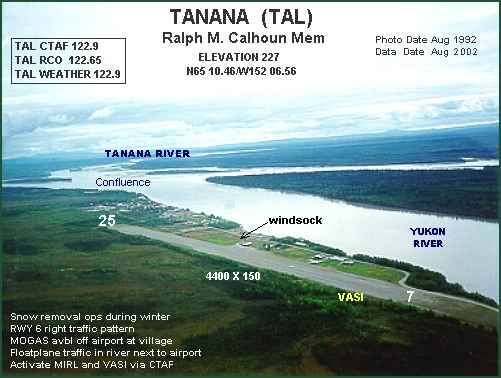
Ralph M. Calhoun Memorial Airport covers an area of 1,650 acres (668 ha) at an elevation of 236 feet (72 m) above mean sea level. It has one runway designated 7/25 with a gravel surface measuring 4,400 by 150 feet (1,341 x 46 m). For the 12-month period ending December 31, 2005, the airport had 3,100 aircraft operations, an average of 258 per month: 55% general aviation, 44% air taxi and 2% military.
Airlines and destinations
- Arctic Circle Air (Fairbanks)
- Frontier Flying Service
- Warbelow's Air Ventures
- Wright Air Service (Fairbanks, Hughes, Huslia)
The above content comes from Wikipedia and is published under free licenses – click here to read more.
Location
& QuickFacts
|
FAA
Information Effective: |
2006-02-16 |
|
Airport
Identifier: |
TAL |
|
Longitude/Latitude: |
152-06-33.7990W/65-10-27.8230N
-152.109389/65.174395 (Estimated) |
|
Elevation: |
227 ft / 69.19 m (Surveyed) |
|
Land: |
1650 acres |
|
From
nearest city: |
1 nautical miles W of Tanana, AK |
|
Location: |
Yukon-koyukuk County, AK |
|
Magnetic Variation: |
19E (2005) |
Owner
& Manager
|
Ownership: |
Publicly owned |
|
Owner: |
State Of Ak Dotpf N Rgn |
|
Address: |
2301 Peger Rd
Fairbanks, AK 99709 |
|
Phone number: |
907-451-5217 |
|
Manager: |
Bill O'halloran |
|
Address: |
2301 Peger Road
Fairbanks, AK 99709 |
|
Phone number: |
907-451-5217 |
Airport
Operations and Facilities
|
Airport
Use: |
Open to public |
|
Wind
indicator: |
Yes |
|
Segmented
Circle: |
Yes |
|
Control
Tower: |
No |
|
Attendance
Schedule: |
UNATNDD |
|
Lighting
Schedule: |
DUSK-DAWN
ACTVT MIRL RY 07/25 & VASI RY 07 - CTAF. |
|
Beacon
Color: |
Clear-Green (lighted land airport) |
|
Landing
fee charge: |
No |
|
Sectional
chart: |
Fairbanks |
|
Region: |
AAL - Alaska |
|
Boundary
ARTCC: |
ZAN - Anchorage |
|
Tie-in
FSS: |
FAI - Fairbanks |
|
FSS
on Airport: |
No |
|
FSS
Phone: |
907-474-0788 |
|
FSS
Toll Free: |
1-866-248-6516 |
|
NOTAMs
Facility: |
TAL (NOTAM-d service avaliable) |
|
Federal Agreements: |
NPY |
Airport
Communications
Airport
Services
|
Fuel
available: |
MOGAS
MOGAS AVBL OFF ARPT AT LOCAL DISTRIBUTORS. |
|
Airframe
Repair: |
NONE |
|
Power
Plant Repair: |
NONE |
|
Bottled
Oxygen: |
NONE |
|
Bulk
Oxygen: |
NONE |
|
Runway Information
Runway 07/25
|
Dimension: |
4400 x 150 ft / 1341.1 x 45.7 m |
|
Surface: |
GRVL, Good Condition |
|
Edge
Lights: |
Medium |
|
|
Runway 07 |
Runway 25 |
|
Longitude: |
152-07-25.1510W |
152-05-42.4210W |
|
Latitude: |
65-10-27.5930N |
65-10-28.1100N |
|
Elevation: |
221.00 ft |
227.00 ft |
|
Alignment: |
89 |
127 |
|
Traffic
Pattern: |
Right |
Left |
|
Crossing
Height: |
26.00 ft |
0.00 ft |
|
VASI: |
4-box on left side |
|
|
Visual
Glide Angle: |
3.00� |
0.00� |
|
Obstruction: |
15 ft road, 125 ft right of centerline |
24 ft trees, 600.0 ft from runway, 40 ft right
of centerline, 25:1 slope to clear |
|
Radio Navigation
Aids
|
ID |
Type |
Name |
Ch |
Freq |
Var |
Dist |
|
BCC |
NDB |
Bear Creek |
|
212.00 |
26E |
2.4 nm |
|
TAL |
VOR/DME |
Tanana |
113X |
116.60 |
26E |
1.7 nm |
Remarks
- SNOW
REMOVAL OPERATIONS DURING WINTER--MONITOR CTAF.
- RY
COND NOT MONITORED; RECOMMEND VISUAL INSPECTION PRIOR TO LANDING.
- FLOATPLANE
TFC IN RIVER ADJ TO ARPT.
- WX
OBSERVER AVBL FOR LOCAL ARPT WX ON CTAF (CALL SIGN: TANANA WEATHER)
& PHONE 907-366-7288 0600-2130.
- WX
CAMERA AVBL ON INTERNET AT HTTP://AKWEATHERCAMS.FAA.GOV
Based Aircraft
|
Aircraft
based on field: |
5 |
|
Single
Engine Airplanes: |
5 |
Operational Statistics
|
Aircraft
Operations: |
60/Week |
|
Air Taxi: |
43.5% |
|
General
Aviation Local: |
38.7% |
|
General
Aviation Itinerant: |
16.1% |
|
Military: |
1.6% |
Ralph M Calhoun Meml Airport
Address:
Yukon-koyukuk County, AK
Tel:
907-451-5217
Images
and information placed above are from
http://www.airport-data.com/airport/TAL/
We
thank them for the data!
| General
Info |
| Country |
United
States |
| State |
ALASKA
|
| FAA ID |
TAL
|
| Latitude |
65-10-27.823N
|
| Longitude |
152-06-33.799W
|
| Elevation |
227 feet
|
| Near City |
TANANA
|
We don't guarantee the information is fresh and accurate. The data may
be wrong or outdated.
For more up-to-date information please refer to other sources.
|
|


