 |
|
|
|
|
|
Location
& QuickFacts
|
FAA
Information Effective: |
2006-02-16 |
|
Airport
Identifier: |
JLA |
|
Longitude/Latitude: |
149-43-07.6880W/60-28-57.8810N
-149.718802/60.482745 (Estimated) |
|
Elevation: |
450 ft / 137.16 m (Estimated) |
|
Land: |
106 acres |
|
From
nearest city: |
3 nautical miles W of Cooper Landing, AK |
|
Location: |
Kenai-cook Inlet County, AK |
|
Magnetic Variation: |
25E (1985) |
Owner
& Manager
|
Ownership: |
Publicly owned |
|
Owner: |
State Of Ak Dotpf-central Rgn |
|
Address: |
P O Box 196900
Anchorage, AK 99519-6900 |
|
Phone
number: |
907-269-0767 |
|
Manager: |
Bob Bondurant/carl High |
|
Address: |
P.o. Box 1327
Soldotna, AK 99669 |
|
Phone number: |
907-262-5762 |
Airport
Operations and Facilities
|
Airport
Use: |
Open to public |
|
Wind
indicator: |
Yes |
|
Segmented
Circle: |
No |
|
Control
Tower: |
No |
|
Attendance
Schedule: |
907-288-3139 |
|
Landing
fee charge: |
No |
|
Sectional
chart: |
Anchorage |
|
Region: |
AAL - Alaska |
|
Boundary
ARTCC: |
ZAN - Anchorage |
|
Tie-in
FSS: |
ENA - Kenai |
|
FSS
on Airport: |
No |
|
FSS
Phone: |
800-478-3576 |
|
FSS
Toll Free: |
1-800-WX-BRIEF |
|
NOTAMs
Facility: |
ENA (NOTAM-d service avaliable) |
Airport
Communications
Airport
Services
|
Airframe
Repair: |
NONE |
|
Power
Plant Repair: |
NONE |
|
Bottled
Oxygen: |
NONE |
|
Bulk
Oxygen: |
NONE |
|
Runway Information
Runway 03/21
|
Dimension: |
2200 x 60 ft / 670.6 x 18.3 m |
|
Surface: |
GRVL, Good Condition |
|
|
Runway 03 |
Runway 21 |
|
Traffic
Pattern: |
Left |
Left |
|
Obstruction: |
39 ft trees, 300.0 ft from runway, 8:1 slope
to clear |
44 ft trees, 370.0 ft from runway, 50 ft left
of centerline, 8:1 slope to clear |
|
Radio Navigation
Aids
|
ID |
Type |
Name |
Ch |
Freq |
Var |
Dist |
|
CMQ |
NDB |
Campbell Lake |
|
338.00 |
21E |
42.5 nm |
|
BOB |
NDB |
Bruck |
|
387.00 |
21E |
43.3 nm |
|
IWW |
NDB |
Wildwood |
|
379.00 |
20E |
44.7 nm |
|
OLT |
NDB/DME |
Soldotna |
106X |
346.00 |
24E |
34.4 nm |
|
EDF |
TACAN |
Elmendorf |
081X |
|
21E |
46.4 nm |
|
ANC |
VOR/DME |
Anchorage |
090X |
114.30 |
25E |
42.6 nm |
|
ENA |
VOR/DME |
Kenai |
123X |
117.60 |
25E |
44.3 nm |
|
ANC |
VOT |
Anchorage |
|
108.40 |
|
42.4 nm |
|
MRI |
VOT |
Merrill |
|
111.00 |
|
44.1 nm |
Remarks
- RY
03/21 EDGES NOT MKD.
- SAFETY
AREA 2750 FT BY 170 FT; 1 FT DEEP RUTS IN SAFETY AREA NORTH OF RY 21
THLD.
- PILOTS
ARE REQUESTED TO SELF-ANNOUNCE ON CTAF PRIOR TO TAXIING ON RWY FOR DEPARTURE;
LEAVING THE RWY AND WITHIN 10 NM OF THE ARPT WHEN APPROACHING TO LAND.
- STATE
MAINTENANCE ON IRREGULAR BASIS.
Based Aircraft
|
Aircraft
based on field: |
6 |
|
Single
Engine Airplanes: |
6 |
Operational Statistics
|
Aircraft
Operations: |
18/Week |
|
Air Taxi: |
5.6% |
|
General
Aviation Local: |
5.6% |
|
General
Aviation Itinerant: |
88.9% |
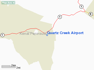
Quartz Creek Airport
Address:
Kenai-cook Inlet County, AK
Tel:
907-269-0767,
907-262-5762
Images
and information placed above are from
http://www.airport-data.com/airport/JLA/
We
thank them for the data!
| General
Info |
| Country |
United
States |
| State |
ALASKA
|
| FAA ID |
JLA
|
| Latitude |
60-28-57.881N
|
| Longitude |
149-43-07.688W
|
| Elevation |
450 feet
|
| Near
City |
COOPER
LANDING |
We don't guarantee the information is fresh and accurate. The data may
be wrong or outdated.
For more up-to-date information please refer to other sources.
|
|


