 |
|
| Point Hope Airport |
 |
| IATA: PHO – ICAO: PAPO – FAA LID: PHO |
| Summary |
| Airport type |
Public |
| Owner |
State of Alaska DOT&PF - Northern Region |
| Serves |
Point Hope, Alaska |
| Elevation AMSL |
12 ft / 4 m |
| Coordinates |
68°20′56″N 166°47′58″W / 68.34889°N 166.79944°W / 68.34889; -166.79944 |
| Runways |
| Direction |
Length |
Surface |
| ft |
m |
| 1/19 |
4,000 |
1,219 |
Asphalt |
| Source: Federal Aviation Administration |
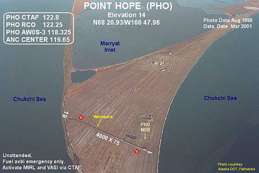
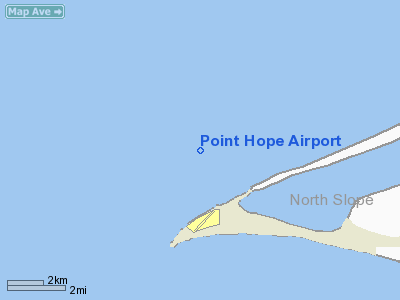
Point Hope Airport (IATA: PHO, ICAO: PAPO, FAA LID: PHO) is a state-owned public-use airport located two miles (3 km) southwest of the central business district of Point Hope, a city in the North Slope Borough of the U.S. state of Alaska. Point Hope is located in the Lisburne Peninsula, on the Chukchi Sea coast. The airport covers an area of 22 acres (9 ha) and contains one asphalt paved runway designated 1/19 which measures 4,000 x 75 ft (1,219 x 23 m).
As per Federal Aviation Administration records, the airport had 4,580 commercial passenger boardings (enplanements) in calendar year 2005 and 4,900 enplanements (4,359 scheduled and 541 unscheduled) in 2006. According to the FAA's National Plan of Integrated Airport Systems for 2007-2011, it is classified as commercial service - non-primary because it has between 2,500 and 10,000 passenger boardings per year.
Airlines and non-stop destinations
- Bering Air (Cape Lisburne, Kotzebue)
- Frontier Flying Service (Kivalina, Kotzebue, Point Lay)
The above content comes from Wikipedia and is published under free licenses – click here to read more.
Location
& QuickFacts
|
FAA
Information Effective: |
2006-02-16 |
|
Airport
Identifier: |
PHO |
|
Longitude/Latitude: |
166-47-57.6600W/68-20-55.8050N
-166.799350/68.348835 (Estimated) |
|
Elevation: |
12 ft / 3.66 m (Surveyed) |
|
Land: |
22 acres |
|
From
nearest city: |
2 nautical miles SW of Point Hope, AK |
|
Location: |
Kobuk County, AK |
|
Magnetic Variation: |
17E (1985) |
Owner
& Manager
|
Ownership: |
Publicly owned |
|
Owner: |
State Of Ak Dot/pf N Reg |
|
Address: |
2301 Peger Road
Fairbanks, AK 99709 |
|
Phone number: |
907-451-5250 |
|
Manager: |
Kenny Gallahorn |
|
Address: |
Po Box 1048
Kotzebue, AK 99752 |
|
Phone number: |
907-442-3147 |
Airport
Operations and Facilities
|
Airport
Use: |
Open to public |
|
Wind
indicator: |
Yes |
|
Segmented
Circle: |
Yes |
|
Control
Tower: |
No |
|
Attendance
Schedule: |
UNATNDD |
|
Lighting
Schedule: |
DUSK-DAWN
ACTVT MIRL RY 01/19; VASI RYS 01 & 19 - CTAF.. |
|
Beacon
Color: |
Clear-Green (lighted land airport) |
|
Landing
fee charge: |
No |
|
Sectional
chart: |
Cape Lisburne |
|
Region: |
AAL - Alaska |
|
Boundary
ARTCC: |
ZAN - Anchorage |
|
Tie-in
FSS: |
OTZ - Kotzebue |
|
FSS
on Airport: |
No |
|
FSS
Phone: |
907-442-3310 |
|
FSS
Toll Free: |
1-478-7460 |
|
Alternate
FSS: |
FAI - Fairbanks |
|
Alt.
FSS Toll Free: |
1-866-248-6516 |
|
NOTAMs
Facility: |
PHO (NOTAM-d service avaliable) |
|
Federal Agreements: |
NGSY |
Airport
Communications
Airport
Services
|
Airframe
Repair: |
NONE |
|
Power
Plant Repair: |
NONE |
|
Bottled
Oxygen: |
NONE |
|
Bulk
Oxygen: |
NONE |
|
Runway Information
Runway 01/19
|
Dimension: |
4000 x 75 ft / 1219.2 x 22.9 m |
|
Surface: |
ASPH, Fair Condition
LATERAL CRACKS 1-3 INCHES ACROSS WIDTH OF RY SPACED 200-500 FT LEN
OF RY. |
|
Edge
Lights: |
Medium |
|
|
Runway 01 |
Runway 19 |
|
Longitude: |
166-48-17.8600W |
166-47-37.4400W |
|
Latitude: |
68-20-37.6000N |
68-21-14.0100N |
|
Elevation: |
7.00 ft |
12.00 ft |
|
Alignment: |
22 |
127 |
|
Traffic
Pattern: |
Left |
Left |
|
Markings: |
Non-precision instrument, Good Condition |
Non-precision instrument, Good Condition |
|
Crossing
Height: |
25.00 ft |
27.00 ft |
|
VASI: |
4-box on left side |
4-box on left side |
|
Visual
Glide Angle: |
3.00� |
3.00� |
|
Radio Navigation
Aids
|
ID |
Type |
Name |
Ch |
Freq |
Var |
Dist |
|
PHO |
NDB |
Point Hope |
|
221.00 |
16E |
0.2 nm |
|
LUR |
NDB/DME |
Cape Lisburne |
20Y |
385.00 |
16E |
35.2 nm |
Remarks
- RY
CONDITION NOT MONITORED; RECOMMEND VISUAL INSPECTION PRIOR TO LANDING.
Point Hope Airport
Address:
Kobuk County, AK
Tel:
907-451-5250, 907-442-3147
Images
and information placed above are from
http://www.airport-data.com/airport/PHO/
We
thank them for the data!
| General
Info |
| Country |
United
States |
| State |
ALASKA
|
| FAA ID |
PHO
|
| Latitude |
68-20-55.805N
|
| Longitude |
166-47-57.660W
|
| Elevation |
12 feet
|
| Near City |
POINT
HOPE |
We don't guarantee the information is fresh and accurate. The data may
be wrong or outdated.
For more up-to-date information please refer to other sources.
|
|


