|
|
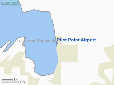
| Pilot Point Airport |
 |
| View from east, looking west |
| IATA: PIP – ICAO: PAPN – FAA LID: PNP |
| Summary |
| Airport type |
Public |
| Owner |
State of Alaska DOT&PF - Central Region |
| Serves |
Pilot Point, Alaska |
| Elevation AMSL |
57 ft / 17 m |
| Coordinates |
57°34′49″N 157°34′19″W / 57.58028°N 157.57194°W / 57.58028; -157.57194 (Pilot Point Airport (new location)) |
| Runways |
| Direction |
Length |
Surface |
| ft |
m |
| 7/25 |
3,280 |
1,000 |
Gravel |
| Statistics (2005) |
| Aircraft operations |
5,300 |
| Enplanements (2008) |
738 |
| Source: Federal Aviation Administration |
Pilot Point Airport (IATA: PIP, ICAO: PAPN, FAA LID: PNP) is a state-owned, public-use airport located in Pilot Point, a city in the Lake and Peninsula Borough of the U.S. state of Alaska. Scheduled airline service to King Salmon Airport is provided by Peninsula Airways (PenAir).
As per Federal Aviation Administration records, this airport had 738 commercial passenger boardings (enplanements) in calendar year 2008, an increase of 9% from the 678 enplanements in 2007. Pilot Point Airport is included in the FAA's National Plan of Integrated Airport Systems (2009-2013), which categorizes it as a general aviation facility.
Although most U.S. airports use the same three-letter location identifier for the FAA and IATA, this airport is assigned PNP by the FAA and PIP by the IATA (which assigned PNP to Girua Airport in Popondetta, Papua New Guinea). Airlines and destinations
Facilities and aircraft
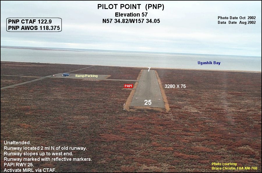
Pilot Point Airport has one runway designated 7/25 with a gravel surface measuring 3,280 by 75 feet (1,000 x 23 m). The airport was previously located at 57°33.79′N 157°33.51′W / 57.56317°N 157.5585°W / 57.56317; -157.5585 (Pilot Point Airport (original location)) where it had an 3,100-by-50-foot (940 × 15 m) runway also designated 7/25.
For the 12-month period ending December 31, 2005, the airport had 5,300 aircraft operations, an average of 14 per day: 66% general aviation and 34% air taxi.
Accidents and incidents
On 1 July 1981, Douglas R4D N111ST of United Aircraft Services crashed shortly after take-off while on a flight to Anchorage International Airport, following the failure of the port engine. All three people on board were killed. The aircraft was on a cargo flight laden with fish.
The above content comes from Wikipedia and is published under free licenses – click here to read more.
Location
& QuickFacts
|
FAA
Information Effective: |
2006-02-16 |
|
Airport
Identifier: |
PNP |
|
Longitude/Latitude: |
157-34-19.0450W/57-34-49.3700N
-157.571957/57.580381 (Estimated) |
|
Elevation: |
57 ft / 17.37 m (Surveyed) |
|
Land: |
0 acres |
|
From
nearest city: |
0 nautical miles NE of Pilot Point, AK |
|
Location: |
Aleutian Islands County, AK |
|
Magnetic Variation: |
17E (2005) |
Owner
& Manager
|
Ownership: |
Publicly owned |
|
Owner: |
State Of Ak Dotpf/c Region |
|
Address: |
Po Box 196900
Anchorage, AK 99613 |
|
Phone
number: |
907-269-0760 |
|
Manager: |
Zane Walker |
|
Address: |
Po Box 65
King Salmon, AK 99613 |
|
Phone number: |
907-246-3325 |
Airport
Operations and Facilities
|
Airport
Use: |
Open to public |
|
Wind
indicator: |
Yes |
|
Segmented
Circle: |
Yes |
|
Control
Tower: |
No |
|
Attendance
Schedule: |
UNATNDD |
|
Lighting
Schedule: |
DUSK-DAWN
ACTVT MIRL RY 07/25 - CTAF. |
|
Beacon
Color: |
Clear-Green (lighted land airport) |
|
Sectional
chart: |
Kodiak |
|
Region: |
AAL - Alaska |
|
Boundary
ARTCC: |
ZAN - Anchorage |
|
Responsible
ARTCC: |
ZAN - Anchorage |
|
Tie-in
FSS: |
ENA - Kenai |
|
FSS
Phone: |
800-478-3576 |
|
FSS
Toll Free: |
1-800-WX-BRIEF |
|
NOTAMs
Facility: |
PTH (NOTAM-d service avaliable) |
|
Federal Agreements: |
NGY |
Airport
Communications
|
Runway Information
Runway 07/25
|
Dimension: |
3280 x 75 ft / 999.7 x 22.9 m |
|
Surface: |
GRVL, Good Condition |
|
Edge
Lights: |
Medium |
|
|
Runway 07 |
Runway 25 |
|
Longitude: |
157-34-49.1300W |
157-33-48.9600W |
|
Latitude: |
57-34-49.3700N |
57-34-49.3700N |
|
Elevation: |
36.00 ft |
57.00 ft |
|
Alignment: |
90 |
127 |
|
Traffic
Pattern: |
Left |
Left |
|
Crossing
Height: |
0.00 ft |
25.00 ft |
|
VASI: |
|
4-light PAPI on left side |
|
Visual
Glide Angle: |
0.00� |
3.00� |
|
Obstruction: |
15 ft road, 400.0 ft from runway, 27:1 slope
to clear |
, 50:1 slope to clear |
|
Remarks
- RY
CONDITIONS NOT MONITORED. RECOMMEND VISUAL INSPECTION PRIOR TO USE.
- PILOTS
ARE REQUESTED TO SELF-ANNOUNCE ON CTAF PRIOR TO TAXIING ON RWY FOR DEPARTURE;
LEAVING THE RWY AND WITHIN 10 NM OF THE ARPT WHEN APPROACHING TO LAND.
- WX
CAMERA AVBL ON INTERNET AT HTTP://AKWEATHERCAMS.FAA.GOV
Based Aircraft
|
Aircraft
based on field: |
4 |
|
Single
Engine Airplanes: |
4 |
Operational Statistics
|
Aircraft
Operations: |
102/Week |
|
Air Taxi: |
34.0% |
|
General
Aviation Local: |
9.4% |
|
General
Aviation Itinerant: |
56.6% |
Pilot Point Airport
Address:
Aleutian Islands County, AK
Tel:
907-269-0760,
907-246-3325
Images
and information placed above are from
http://www.airport-data.com/airport/PNP/
We
thank them for the data!
| General
Info |
| Country |
United
States |
| State |
ALASKA
|
| FAA ID |
PNP
|
| Latitude |
57-34-49.370N
|
| Longitude |
157-34-02.800W
|
| Elevation |
57 feet
|
| Near City |
PILOT
POINT |
We don't guarantee the information is fresh and accurate. The data may
be wrong or outdated.
For more up-to-date information please refer to other sources.
|
|