 |
|
|
|
|
|
Location
& QuickFacts
|
FAA
Information Effective: |
2006-02-16 |
|
Airport
Identifier: |
PXK |
|
Longitude/Latitude: |
145-30-01.9830W/63-01-28.4880N
-145.500551/63.024580 (Estimated) |
|
Elevation: |
2653 ft / 808.63 m (Estimated) |
|
Land: |
0 acres |
|
From
nearest city: |
0 nautical miles S of Paxson, AK |
|
Location: |
Valdez-chitna-whitie County, AK |
|
Magnetic Variation: |
28E (1985) |
Owner
& Manager
|
Ownership: |
Privately owned |
|
Owner: |
Paxson Lodge Inc. |
|
Address: |
Paxson, AK 99737 |
|
Phone
number: |
907-822-3330 |
|
Manager: |
Chet & Karen Eldridge |
|
Address: |
Paxon Lodge Inc
Paxson, AK 99737 |
|
Phone number: |
907-822-3330 |
Airport
Operations and Facilities
|
Airport
Use: |
Open to public |
|
Wind
indicator: |
Yes |
|
Segmented
Circle: |
No |
|
Control
Tower: |
No |
|
Attendance
Schedule: |
ALL/ALL/DALGT |
|
Landing
fee charge: |
No |
|
Sectional
chart: |
Anchorage |
|
Region: |
AAL - Alaska |
|
Boundary
ARTCC: |
ZAN - Anchorage |
|
Tie-in
FSS: |
ENA - Kenai |
|
FSS
on Airport: |
No |
|
FSS
Phone: |
800-478-3576 |
|
FSS
Toll Free: |
1-800-WX-BRIEF |
|
NOTAMs
Facility: |
PXK (NOTAM-d service avaliable) |
Airport
Communications
Airport
Services
|
Airframe
Repair: |
NONE |
|
Power
Plant Repair: |
NONE |
|
Bottled
Oxygen: |
NONE |
|
Bulk
Oxygen: |
NONE |
|
Runway Information
Runway 13/31
|
Dimension: |
2800
x 65 ft / 853.4 x 19.8 m
USABLE LENGTH 2000 FT DUE TO SE END OVERGROWN WITH BRUSH AND TALL
GRASS.
USABLE
WIDTH VARIES 20-30 FEET |
|
Surface: |
GRAVEL, Poor Condition
RY SURFACE IS NOT MAINTAINED WINTER OR SUMMER AND IS MORE DIRT THAN
GRAVEL. 18 IN DIA HOLE 8 IN DEEP 650 FT FROM RWY 31 THLD.RY OVERGROWN
WITH BRUSH AND GRASS ROCKS TO 5 IN CENTER OF RY AND SMALL BOULDERS
TO 2 FT DIA IN GRASS ALONG EITHER SIDE WITHIN 20 FT OF CENTERLINE.
RUTS
LENGTH OF RY. |
|
|
Runway 13 |
Runway 31 |
|
Traffic
Pattern: |
Left |
Left |
|
Obstruction: |
26 ft trees, 200.0 ft from runway, 7:1 slope
to clear |
23 ft trees, 585.0 ft from runway, 25:1 slope
to clear |
|
Radio Navigation
Aids
|
ID |
Type |
Name |
Ch |
Freq |
Var |
Dist |
|
GLA |
NDB |
Glennallen |
|
248.00 |
28E |
49.9 nm |
Remarks
- NO
WINTER MAINT.
- AUTO
FUEL AVBL IN EMERGENCY.
- ISABEL
PASS WX CAMERA AVBL ON INTERNET AT HTTP://AKWEATHERCAMS.FAA.GOV
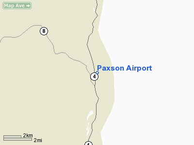
Paxson Airport
Address:
Valdez-chitna-whitie County, AK
Tel:
907-822-3330
Images
and information placed above are from
http://www.airport-data.com/airport/PXK/
We
thank them for the data!
| General
Info |
| Country |
United
States |
| State |
ALASKA
|
| FAA ID |
PXK
|
| Latitude |
63-01-28.488N
|
| Longitude |
145-30-01.983W
|
| Elevation |
2653 feet
|
| Near City |
PAXSON
|
We don't guarantee the information is fresh and accurate. The data may
be wrong or outdated.
For more up-to-date information please refer to other sources.
|
|


