 |
|
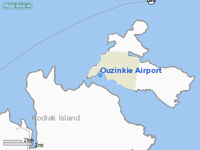
| Ouzinkie Airport |
| IATA: KOZ – ICAO: (none) – FAA LID: 4K5 |
| Summary |
| Airport type |
Public |
| Owner |
State of Alaska DOT&PF - Central Region |
| Location |
Ouzinkie, Alaska |
| Elevation AMSL |
55 ft / 17 m |
| Coordinates |
57°55′22.354″N 152°30′1.84″W / 57.92287611°N 152.5005111°W / 57.92287611; -152.5005111 |
| Runways |
| Direction |
Length |
Surface |
| ft |
m |
| 11/29 |
2,085 |
636 |
Gravel |
| Statistics (2006) |
| Aircraft operations |
42/month |
Ouzinkie Airport (IATA: KOZ, FAA LID: 4K5) is a state-owned public-use airport located southwest of Ouzinkie, a city in the Kodiak Island Borough of the U.S. state of Alaska. It has come under considerable national media attention after being slotted to receive $15 million in federal stimulus money. That money, however, is being used to construct a new airstrip about two miles north of the current Ouzinkie airport's location. Facilities and aircraft
Ouzinkie Airport has one runway (11/29) with a gravel surface measuring 2,085 x 80 ft. (636 x 24 m). For the 12-month period ending December 31, 2006, the airport had 42 aircraft operations per month: 60% general aviation and 40% air taxi.
Airlines and destinations
- Island Air Service (Kodiak, Port Lions)
- Servant Air (Kodiak, Port Lions)
The above content comes from Wikipedia and is published under free licenses – click here to read more.
Location
& QuickFacts
|
FAA
Information Effective: |
2006-02-16 |
|
Airport
Identifier: |
4K5 |
|
Longitude/Latitude: |
152-30-01.8400W/57-55-22.3540N
-152.500511/57.922876 (Estimated) |
|
Elevation: |
55 ft / 16.76 m (Estimated) |
|
Land: |
0 acres |
|
From
nearest city: |
0 nautical miles N of Ouzinkie, AK |
|
Location: |
Kodiak County, AK |
|
Magnetic Variation: |
22E (1985) |
Owner
& Manager
|
Ownership: |
Publicly owned |
|
Owner: |
State Of Ak Dotpf-central Rgn |
|
Address: |
Po Box 196900
Anchorage, AK 99519-6900 |
|
Phone
number: |
907-269-0767 |
|
Manager: |
Robert Green |
|
Address: |
1500 Anton Larsen Rd
Kodiak, AK 99615 |
|
Phone number: |
907-487-4952 |
Airport
Operations and Facilities
|
Airport
Use: |
Open to public |
|
Wind
indicator: |
Yes |
|
Segmented
Circle: |
Yes |
|
Control
Tower: |
No |
|
Attendance
Schedule: |
UNATNDD |
|
Sectional
chart: |
Kodiak |
|
Region: |
AAL - Alaska |
|
Boundary
ARTCC: |
ZAN - Anchorage |
|
Tie-in
FSS: |
ENA - Kenai |
|
FSS
Phone: |
800-478-3576 |
|
FSS
Toll Free: |
1-800-WX-BRIEF |
|
NOTAMs
Facility: |
ADQ (NOTAM-d service avaliable) |
|
Federal Agreements: |
N |
Airport
Communications
|
Runway Information
Runway 11/29
|
Dimension: |
2085
x 80 ft / 635.5 x 24.4 m
USABLE WIDTH BETWEEN MARKERS IS 60 FT. |
|
Surface: |
GRVL, Good Condition |
|
|
Runway 11 |
Runway 29 |
|
Traffic
Pattern: |
Right |
Left |
|
Obstruction: |
, 50:1 slope to clear |
112 ft trees, 1800.0 ft from runway, 100 ft
right of centerline, 16:1 slope to clear |
|
Radio Navigation
Aids
|
ID |
Type |
Name |
Ch |
Freq |
Var |
Dist |
|
RWO |
NDB |
Woody Island |
|
394.00 |
23E |
10.6 nm |
|
ODK |
VORTAC |
Kodiak |
118X |
117.10 |
23E |
10.3 nm |
Remarks
- LARGE
RED/WHITE BOARD MARKERS IDENTIFY END OF 2485 FT BY 100 FT SAFETY AREA
& ARE APPROXIMATELY 180 FT BEFORE LANDING THR RY 11.
- CAUTION:
RWY CONDITION NOT MONITORED; RECOMMEND VISUAL INSPECTION PRIOR TO LANDING.
- FREQUENT
VEH TRAFFIC CROSSING RY TO & FROM QUARRY.
- PILOTS
ARE REQUESTED TO SELF-ANNOUNCE ON CTAF PRIOR TO TAXIING ON RWY FOR DEPARTURE;
LEAVING THE RWY AND WITHIN 10 NM OF THE ARPT WHEN APPROACHING TO LAND.
Operational Statistics
|
Aircraft
Operations: |
10/Week |
|
Air Taxi: |
40.0% |
|
General
Aviation Local: |
20.0% |
|
General
Aviation Itinerant: |
40.0% |
Ouzinkie Airport
Address:
Kodiak County, AK
Tel:
907-269-0767,
907-487-4952
Images
and information placed above are from
http://www.airport-data.com/airport/4K5/
We
thank them for the data!
| General
Info |
| Country |
United
States |
| State |
ALASKA
|
| FAA ID |
4K5
|
| Latitude |
57-55-22.354N
|
| Longitude |
152-30-01.840W
|
| Elevation |
55 feet
|
| Near City |
OUZINKIE
|
We don't guarantee the information is fresh and accurate. The data may
be wrong or outdated.
For more up-to-date information please refer to other sources.
|
|


