|
|
| Nome Airport |
 |
| IATA: OME – ICAO: PAOM – FAA LID: OME |
| Summary |
| Airport type |
Public |
| Owner |
Alaska DOT&PF - Northern Region |
| Serves |
Nome, Alaska |
| Elevation AMSL |
37 ft / 11 m |
| Coordinates |
64°30′44″N 165°26′43″W / 64.51222°N 165.44528°W / 64.51222; -165.44528 |
| Runways |
| Direction |
Length |
Surface |
| ft |
m |
| 3/21 |
5,576 |
1,700 |
Asphalt |
| 10/28 |
6,001 |
1,829 |
Asphalt |
| Statistics (2008) |
| Aircraft operations |
28,000 |
| Based aircraft |
71 |
| Source: Federal Aviation Administration |
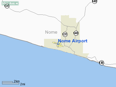
Nome Airport (IATA: OME, ICAO: PAOM, FAA LID: OME) is a state-owned public-use airport located two nautical miles (3.7 km) west of the central business district of Nome, a city in the Nome Census Area of the U.S. state of Alaska.
The State of Alaska also operates Nome City Field (FAA LID: 94Z), a public general aviation airfield located one nautical mile (1.85 km) north of the city. Facilities and aircraft
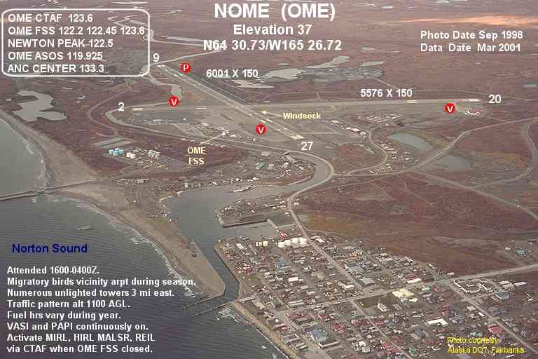
Nome Airport has two asphalt paved runways: 3/21 measures 5,576 by 150 feet (1,700 x 46 m) and 10/28 is 6,001 by 150 feet (1,829 x 46 m).
For the 12-month period ending November 1, 2008, the airport had 28,000 aircraft operations, an average of 76 per day: 54% air taxi, 36% general aviation, 5% scheduled commercial and 5% military. At that time there were 71 aircraft based at this airport: 72% single-engine, 17% multi-engine, 7% helicopter and 4% military.
Free parking is available at the airport.
Airport Pizza
Located at the airport is a pizza restaurant named Airport Pizza. The pizza parlor is famous for its use of Bering Air flights to deliver pizza for free to far-flung Alaskan villages.
Airlines and non-stop destinations
| Airlines |
Destinations |
| Alaska Airlines |
Anchorage, Kotzebue |
| Arctic Transportation Services |
Brevig Mission, Elim, Gambell, Golovin,Savoonga, Shishmaref, Teller, Unalakleet, Wales, White Mountain |
| Bering Air |
Anadyr, Brevig Mission, Council, Elim, Gambell, Golovin, Kotzebue, Koyuk, Little Diomede, Port Clarence, Provideniya, Saint Michael, Savoonga, Shaktoolik, Shishmaref, Stebbins, Teller, Tin City, Unalakeet, Wales, White Mountain |
| Frontier Flying Service |
|
| Hageland Aviation Services |
Elim, Gambell, Golovin, Savoonga, Shaktoolik, Shishmaref, Stebbins, White Mountain, Brevig Mission, Teller, Wales, Unalakeet |
| Evergreen Helicopters |
Wales, Little Diomede |
Military use
Nome Airport was used as a transport base during World War II, facilitating the transit of Lend-Lease aircraft to the Soviet Union. Known as Marks Army Airfield it shared the facility with the civilian Nome Airport. It also was used as a defensive airfield in 1942 by the United States Army Air Force for the western coast of Alaska. Known USAAF units assigned were:
- 404th Bombardment Squadron (July 18–28, 1942) (28th BG)
- 56th Fighter Squadron (June 20 – October 20, 1942) (54th FG)
Renamed Marks Air Force Base in 1948, it was used as a cold weather survival school and a fighter-interceptor forward base. Marks was too close to the USSR to operate defending fighter-interceptors, so they were pulled back to Galena Airport. Although Marks AFB closed in 1950, an air base squadron was at Nome Airport until December 1956.
The above content comes from Wikipedia and is published under free licenses – click here to read more.
Location
& QuickFacts
|
FAA
Information Effective: |
2006-02-16 |
|
Airport
Identifier: |
OME |
|
Longitude/Latitude: |
165-26-42.8850W/64-30-43.9280N
-165.445246/64.512202 (Estimated) |
|
Elevation: |
37 ft / 11.28 m (Surveyed) |
|
Land: |
0 acres |
|
From
nearest city: |
2 nautical miles W of Nome, AK |
|
Location: |
Nome County, AK |
|
Magnetic Variation: |
14E (2005) |
Owner
& Manager
|
Ownership: |
Publicly owned |
|
Owner: |
St Of Ak Dotpf North Reg |
|
Address: |
2301 Peger Rd
Fairbanks, AK 99709 |
|
Phone
number: |
907-443-2500 |
|
Manager: |
Jerry Oliver |
|
Address: |
Box 1048
Nome, AK 99762 |
|
Phone number: |
907-443-2500 |
Airport
Operations and Facilities
|
Airport
Use: |
Open to public |
|
Wind
indicator: |
Yes |
|
Segmented
Circle: |
Yes |
|
Control
Tower: |
No |
|
Attendance
Schedule: |
ALL/ALL/0700-2100 |
|
Lighting
Schedule: |
DUSK-DAWN
HIRL RY 10/28; MIRL RY 03/21 & REIL RY 03 OPER 24 HRS.
ACTVT MALSR RY 28 - CTAF. REIL RY 10; VASI RYS 03, 21 &
10 PAPI 28 OPERS CONTINUOUSLY. |
|
Beacon
Color: |
Clear-Green (lighted land airport) |
|
Landing
fee charge: |
No |
|
Sectional
chart: |
Nome |
|
Region: |
AAL - Alaska |
|
Traffic
Pattern Alt: |
1100 ft |
|
Boundary
ARTCC: |
ZAN - Anchorage |
|
Tie-in
FSS: |
OME - Nome |
|
FSS
on Airport: |
Yes |
|
FSS
Phone: |
LC 443-2291 |
|
FSS
Toll Free: |
1-800-478-8400 |
|
Alternate
FSS: |
FAI - Fairbanks |
|
Alt.
FSS Toll Free: |
1-866-248-6516 |
|
NOTAMs
Facility: |
OME (NOTAM-d service avaliable) |
|
Certification
type/date: |
I BS ??/????
ARFF SVC AVBL DRG PERIODS OF ACR OPNS ONLY; PPR IN WRITING
FOR ACR OPNS WITH MORE THAN 30 PSGR SEATS TO AMGR PO BOX
1048 NOME AK 99762. |
|
Federal Agreements: |
NGPY |
Airport
Communications
Airport
Services
|
Fuel
available: |
100LLA A1+
FUEL HRS VARY DURING YEAR. CALL OUT AVBL AFT HRS. |
|
Airframe
Repair: |
MINOR |
|
Power
Plant Repair: |
MINOR |
|
Bottled
Oxygen: |
NONE |
|
Bulk
Oxygen: |
NONE |
|
Runway Information
Runway 03/21
|
Dimension: |
5576 x 150 ft / 1699.6 x 45.7 m |
|
Surface: |
ASPH, Good Condition |
|
Surface
Treatment: |
Saw-cut or plastic Grooved |
|
Edge
Lights: |
Medium |
|
|
Runway 03 |
Runway 21 |
|
Longitude: |
165-27-06.4150W |
165-25-41.7250W |
|
Latitude: |
64-30-26.0280N |
64-31-07.0160N |
|
Elevation: |
12.00 ft |
36.00 ft |
|
Alignment: |
42 |
127 |
|
Traffic
Pattern: |
Left |
Left |
|
Markings: |
Non-precision instrument, Fair Condition |
Non-precision instrument, Fair Condition |
|
Crossing
Height: |
42.00 ft |
34.00 ft |
|
VASI: |
4-box on left side |
4-box on left side
VASI UNUSBL BEYOND 2 1/2 NM. |
|
Visual
Glide Angle: |
4.00� |
3.00� |
|
Runway
End Identifier: |
Yes |
|
|
Obstruction: |
53 ft pline, 1400.0 ft from runway, 22:1 slope
to clear |
23 ft road, 600.0 ft from runway, 17:1 slope
to clear
GROUND 100' FM THR. |
|
Runway 10/28
|
Dimension: |
6001 x 150 ft / 1829.1 x 45.7 m |
|
Surface: |
ASPH, Good Condition |
|
Surface
Treatment: |
Saw-cut or plastic Grooved |
|
Weight
Limit: |
Single wheel: 150000 lbs.
Dual wheel: 150000 lbs.
Dual
tandem wheel: 320000 lbs. |
|
Edge
Lights: |
High |
|
|
Runway 10 |
Runway 28 |
|
Longitude: |
165-28-04.8600W |
165-25-55.8800W |
|
Latitude: |
64-30-51.4910N |
64-30-31.5330N |
|
Elevation: |
16.00 ft |
21.00 ft |
|
Alignment: |
110 |
127 |
|
ILS
Type: |
MLS |
ILS
|
|
Traffic
Pattern: |
Left |
Left |
|
Markings: |
Precision instrument, Fair Condition |
Precision instrument, Fair Condition |
|
Crossing
Height: |
42.00 ft |
51.00 ft |
|
VASI: |
4-box on left side |
4-light PAPI on left side |
|
Visual
Glide Angle: |
3.00� |
3.00� |
|
RVR
Equipment: |
|
touchdown |
|
Approach
lights: |
|
MALSR |
|
Runway
End Identifier: |
Yes |
|
|
Obstruction: |
18 ft hill, 300.0 ft from runway, 250 ft right
of centerline, 5:1 slope to clear |
80 ft hill, 2500.0 ft from runway, 28:1 slope
to clear |
|
Radio Navigation
Aids
|
ID |
Type |
Name |
Ch |
Freq |
Var |
Dist |
|
FDV |
NDB |
Fort Davis |
|
529.00 |
14E |
3.6 nm |
|
OYN |
NDB/DME |
Gold |
085X |
208.00 |
14E |
0.3 nm |
|
OME |
VOR/DME |
Nome |
097X |
115.00 |
17E |
5.2 nm |
Remarks
- RY
03/21 & 10/28 RY LGTS HEIGHT 30 INCHES ABV GND.
- SNOW
REMOVAL OR DEICING PERFORMED DURING DUTY HRS.
- ANG
AVN FLT ACTVT PHONE 907-443-2831 FOR NG HGR; OPERS 0800-1700.
LTD MAINT & SVCS AVBL.
- RY
CONDITIONS REPORT DURING DUTY HRS.
- LARGE
FLOCKS OF MIGRATORY BIRDS INVOF ARPT SEP-OCT & MAY-JUN.
- ACFT
LANDING RYS 21 & 28 MAINTAIN TPA UNTIL TURNING FINAL.
- MARKED
TRANSIENT ACFT PARKING AVAILABLE.
Based Aircraft
|
Aircraft
based on field: |
71 |
|
Single
Engine Airplanes: |
51 |
|
Multi
Engine Airplanes: |
12 |
|
Helicopters: |
5 |
|
Military: |
3 |
Major Carriers
Serving This Airport
Most Popular Destinations
|
Ted Stevens Anchorage Intl (ANC) |
67.4% |
| Ralph Wien Memorial (OTZ) |
32.6% |
Most Popular Aircraft
|
N746AS |
17.0% |
| N741AS |
16.3% |
|
N747AS |
16.3% |
| N745AS |
14.9% |
|
N742AS |
10.6% |
| N730AS |
10.3% |
|
N740AS |
6.4% |
| 000000 |
5.0% |
|
N754AS |
1.1% |
| N771AS |
0.7% |
Operational Statistics
|
Aircraft
Operations: |
81/Day |
|
Air Carrier: |
5.1% |
|
Air Taxi: |
50.8% |
|
General
Aviation Local: |
16.9% |
|
General
Aviation Itinerant: |
16.9% |
|
Military: |
5.1% |
Nome Airport
Address:
Nome County, AK
Tel:
907-443-2500
Images
and information placed above are from
http://www.airport-data.com/airport/OME/
We
thank them for the data!
| General
Info |
| Country |
United
States |
| State |
ALASKA
|
| FAA ID |
OME
|
| Latitude |
64-30-43.928N
|
| Longitude |
165-26-42.885W
|
| Elevation |
37 feet
|
| Near City |
NOME
|
We don't guarantee the information is fresh and accurate. The data may
be wrong or outdated.
For more up-to-date information please refer to other sources.
|
|